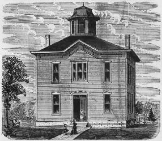
PUBLIC SCHOOL BUILDING, STERLING.
|
410 |
|
neat cattle 7,280, value $52,181; sheep 1,334, value $670.00; swine 14,257, value $14,058; vehicles 932, value $11,611; moneys and credits, $10,472; mortgages, $6,830; stocks, $12.00; furniture, $8,909; libraries, $255; property not enumerated, $15,207. Railroads, $128,243.92. Total valuation for 1879, $1,201,164.92.
MISCELLANEOUS.--The price of land ranges from $4.00 to $10.00 per acre, wild, and $5.00 to $25.00, improved. There are twenty-six miles of railway, thirteen Churches, three newspapers, one bank and four flouring mills in the County.
POPULATION.--The following are the Precincts and population of each in 1879: Vesta, 853; Helena, 607; Todd Creek 929; Lincoln, 529; Spring Creek, 535; Nemaha, 1,695; Sterling, 1,160. Total population of County, 6,302--males, 3,391, females, 2,912.
The County Seat, has 1,400 inhabitants. It is situated in the valley of the Great Nemaha, near the geographical center of the County, and was located and surveyed in 1856. The town was first christened "Frances," after the wife of General R. M. Johnson, but the name was shortly afterwards changed to Tecumseh, the name of the famous Indian warrior, who is supposed to have been killed in battle by General Johnson.
Tecumseh is the largest city on the line of the Atchison & Nebraska Railroad in Nebraska, south of Lincoln and west of Falls City. Her shipping and general merchandise trade is very large. The general business of the place is represented by an array of as finely fitted up stores and offices as can be found anywhere in a town of its size in the west. It contains one steam and one water power flouring mill, two stock yards, large elevators and grain warehouses, two weekly newspapers, the Chieftain and the Journal, several Churches, etc. The court house was erected in 1868 at a cost of $2,800. It is built of stone and stands in the center of the city, the grounds fenced in and ornamented with shade trees. In 1873 a magnificent stone school building was erected at a cost of $10,000; architect and builder, Mr. W. L. Dunlap. The County jail was erected in 1873. It is a solid stone structure, and is a terror to evil-doers. A splendid iron bridge--said to have been the first
|
|
411 |
erected in the State--spans the river at this point, which, besides the great convenience it affords the general public, is the means of drawing an immense trade from the country lying to the southwest
PUBLIC SCHOOL BUILDING, STERLING.
On the line of the A. & N. Railroad, twelve miles northwest of Tecumseh, was surveyed in 1870, and at present contains seven hundred and fifty inhabitants. It is nicely located in the valley of the Nemaha and has excellent mill privileges close at hand. A first-class flouring mill was erected here in 1870 by Wm. Mann, and is kept running to its full capacity. A substantial bridge spans the, river, adding greatly to the business of the place. The Methodist Church was erected in 1875, at a cost of $800. The Baptist Church
|
412 |
|
was built in 1876 and cost $1,500. The town is building up very rapidly and is now the next best business point on the line of the A. & N. Road after Tecumseh. It contains a couple dozen stores and other business houses, good hotels, fine shipping facilities, large lumber yards, elegant school. house and a flourishing weekly news paper, the News.
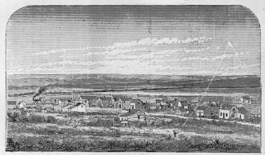
ELK CREEK, IN THE NEMAHA VALLEY.
|
|
413 |
Is a prosperous town of 300 inhabitants located on the A. & N. Railroad seven miles southeast of the County Seat. It was surveyed in 1873. An excellent water-power flouring mill is in operation here. The town is well provided with stores, has good Church and school privileges, a lumber yard, elevator, stock yards, etc.
Is located on the south branch of the Little Nemaha River in the north eastern part of the County. It was surveyed in 1867 and for awhile improved very rapidly. In 1870 the Presbyterians and Lutherans each erected neat houses of worship here. Good bridges span the streams in: the vicinity, and make this a center for trade.
Is situated nine miles west of the County Seat, in the midst of a well-settled farming region. It was laid out as a town several years ago and has improved steadily as a business point. Fanning & Hall erected a steam sawmill here in 1866. There are now good stores, several mechanics' shops, fine school house, and other evidences of prosperity.
SPRING CREEK, CRAB ORCHARD, and LATROBE are Postoffices in the County.
Keith County was organized in July, 1873. It is located in the western part of the State, bounded on the north by unorganized territory, east by Lincoln County, south by Hayes and Chase Counties, and west by State of Colorado and Cheyenne County, containing 2,016 square miles, or 1,290,240 acres, at an average elevation of 3,190 feet above the sea level.
The County is watered by the North and South Forks of the Platte River and their tributaries. The North Fork flows in a southeasterly direction, and the South Fork in a northeasterly
|
414 |
|
direction through the County, running nearly parallel and from three to six miles &part for the latter half of the distance.
Timber is scarce in the County. Scattered quantities are found along the Plattes and in the canyons.
With the exception of the valleys of the Plattes, which are here from two to five miles wide, the surface of the country consists of rolling prairie and tables, with high bluff and deep canyons along the streams. The prairies, with the aid of irrigation, maybe made to yield excellent crops of small grain and vegetables. Very little attention is given to agriculture, however, stock-raising being the almost exclusive industry engaged in.
Keith is one of the greatest stock Counties in the State, and annually ships thousands of fat cattle to the Eastern markets. There are several ranches established in favorable localities whose herds are numbered by the thousands of head, and no country possesses finer advantages for the business. The high plains and slopes produce nutritious grasses, which, when ripe, dry upon the stock, forming uncut hay superior to that prepared by the most careful curing in the agricultural States, and upon which stock subsist, in excellent condition, the year through. The canyons or hollows among the bluffs skirting the streams furnish protection and shelter to the stock during storms.
The first permanent settlements in the County were made in 1867, at the time of the building of the Union Pacific Railroad, which traverses the County from east to west, following the Valley of the South Platte.
During the building of the railroad through the County, considerable trouble was had with the Indians, every now and then; and even after the road was completed, attempts to wreck the trains were frequent. In September, 1868, a band of Sioux attempted to destroy a train between Alkali and Ogalalla. They fixed the rails the same as at Plum Creek, raising one end of each rail about three feet high, and piling ties under them for support. As the train came up, the rails penetrated the cylinders on each side of the engine, as it was a straight track there; the engine going over into the ditch, with the cars piling up on top of it. The engineer and one of the brakemen who was on the engine at the time, went thrown through the window of the cab, and were but little hurt.
|
|
415 |
The fireman was fastened by the tender against the end of the boiler, and after the train had stopped, there being no draft, the flames of the fire came out of the door to the fire-box upon him, and the poor fellow was literally roasted alive. He was released after six hours in this terrible position, during which he begged the attendants to kill him, but lived only a few moments after his release. All the trains at this time carried arms; and the conductor, with two or three passengers, among whom was Father Ryan, a Catholic Priest of Columbus, Nebraska, seized the arms and defended the train--the Indians meanwhile skulking among the bluffs near the track, and occasionally firing a shot. Word was sent to North Platte, and an engine and men came up, who cleared the wreck. Meanwhile word was sent to Major North, then at Willow Island, to take one company of his scouts and follow the Indians. He came to Alkali and reported to Colonel Mizner, who was marching for North Platte with two companies of cavalry, all of whom started in pursuit. They went over to the North Platte River, crossed that stream, and entered the sand-hills, where the scouts overtook and killed two of the Indians, the whole party going about thirty-five miles, to a little lake, where the main body of the Indians had just left, and camped, finding the smouldering embers of the Indian fires still alive. That night, some of the white soldiers let their camp fires get away into the prairie, and an immense prairie fire was the result. This, of course, alarmed the Indians, and further pursuit was abandoned, much to to the disgust of the scouts.
TAXABLE PROPERTY.--Acres of land, 240; average value per acre, $1.00. Value of town lots, $2,485. Money invested in merchandise, $1,800; money used in manufactures, $11,780; horses 192, value $3,080; mules, six, value $200; neat cattle 19,094, value $115,032; swine, twenty-four, value $46; vehicles, fifteen, value $450; moneys and credits, $450; mortgages, $250; furniture, $590; railroad, $425,006; telegraph, $3,485. Total valuation for 1879, $564,894.
The Union Pacific Railroad Company owns many thousands of acres of land in this County, and the balance is nearly all government land.
The estimated population of the County in 1879, was 274.
|
416 |
|
The County Seat, is situated on the Union Pacific Railroad, 351 miles west of Omaha, and near the geographical center of the County. It is the headquarters of an immense cattle trade, Texas and other cattle being driven here for distribution to the various ranches. It is also a great shipping point for stock. It contains two large general merchandise stores, two hotels, a school house, blacksmith shops, etc., and about one hundred and twenty-five permanent inhabitants, although during the shipping season it has a large floating population and business is very brisk.
ALKALI, ROSCOE and BRULE, are small stations on the railroad.,
Kearney County was created by an Act of the Territorial Legislature in 1859, and named in honor of General Phil. Kearney, U. S. A., who established the military post of Fort Kearney, in 1848. In 1873 the Legislature redefined the boundaries of the County as they exist at present. It lies in the south-central part of the State, bounded on the north by the Platte River, which separates it from Buffalo County, east by Adams, south by Franklin, and west by Phelps County, containing 505 square miles, or 323,200 acres, at an average elevation of 2,100 feet above the sea level.
WATER COURSES.--The Platte River washes the northern border of the County, while the southern and eastern portions are drained by numerous feeders of the Republican and Little Blue Rivers.
CHARACTER OF THE LAND.--The northern portion of the County is included in the wide fertile bottoms of the Platte, which, with the valleys of the smaller streams, comprise about twenty per cent. of the area; the remainder consisting of broad tables, rolling prairie and a small percent. bluff. A large proportion is very nearly level prairie which drains by percolation to the strata below, while in the southwestern portion of the County there are numerous hollows
|
|
417 |
in which lakelets are formed. Well water can be had almost anywhere on the uplands at a depth of forty to 100 feet. The soil is well adapted to the growth of cereal crops and yields bountifully wherever tested.
TIMBER.--With the exception of the small quantities found along the Platte and on the islands of that stream, there is scarcely any timber of natural growth in the County. The artificial groves are now well grown and present a fine appearance on the broad prairies. 668,944 forest trees are reported under cultivation, besides four miles of hedge fencing.
FRUIT.--The number of fruit trees planted up to 1879, was as follows: Apple, 1,185; pear, 13, peach, 1,696, plum,. 255, cherry, 224.
HISTORICAL.--The Fort Kearney Reservation, which occupied a tract of land ten miles square, lying on either side of the Platte River, mostly in Kearney County, was set apart by the general Government for the establishment of a fort thereon for the protection of emigrants traveling across the Continent to California and the Territories. A detachment of Missouri volunteers first erected and occupied a small fort here, which they named Fort Childs, after their commanding officer, and which was also made a depot by the Mormons while crossing the plains to Salt Lake. In 1848, Col. Phil. Kearney arrived here with the Second United States Dragoons, rebuilt the fort, planted shade trees, and made other substantial improvements, and the name of Fort Kearney was given to the Post, after its distinguished commander.
The Fort being located on the main overland road across the plains, in the midst of powerful and hostile tribes of Indians, at once became the central point of rendezvous between the settlements in the eastern part of the State and the Rocky Mountains, and extended its sheltering arms to many a weary pilgrim band to the Far West.
The following troops have guarded at the Fort in the order named, viz.: The Missouri Volunteers, Second United States Dragoons, Sixth United States Infantry, Fourth United States Artillery, Second United States Infantry, Third United States Artillery, Thirteenth United States Infantry, Ninth United States Infantry, Second United States Cavalry, Tenth United States Infantry,
27
|
418 |
|
Seventh Iowa Cavalry, First Nebraska Cavalry, Second Nebraska Cavalry, Nebraska Militia, Ninth Ohio Cavalry, Twelfth Missouri Infantry, and Fourteenth Kansas Infantry, besides New York, Michigan, Massachusetts and Tennessee Regiments for short periods each.
The commanding officers have been as follows: Capt. Childs, Col. Phil. Kearney, Capt. E. B. Wharton, Maj. R. E. Morris, Col. C. A. May, Capt. E. McCown, Col. E. B. Alexander, Col. Miles, Gen. Carrington, Gen. Gibbon, Col. Foulke, Major Dallas, Capt. Pollock, Capt. Tenton, Col. R. Livingstone, Col. Baumer, Capt. Gillette, Major Wood, Gen. H. H. Heath, Col. Sumner, Capt. C. L. Tyler, etc.
At first the buildings of the Fort were made of sod and sun dried brick, or adobe, but when Col. C. A. May took command, in 1858, he had two saw mills erected, and they were rebuilt with cottonwood lumber sawed from the timber on the islands of the Platte. The trees which tower up so magnificently and shade the grounds around, were planted in 1848.
The winter of 1856-57 was a remarkably severe one at the Fort. About the 9th of February, a terrific snow storm came up which buried all the one story houses under. A young man employed in the sutler's store, having to go from his boarding house in one part of the Fort to his lodging place in another, missed his way in the blinding storm and perished, his remains being found in April following, by some Pawnees, several miles distant.
While Major Morris was in command of the Fort, serious trouble was apprehended with the Pawnees. A Pawnee boy had been killed by a soldier--whether accidentally or in a quarrel it is not known--which greatly excited them, and they came to the Fort in full force, in war-paint and feathers, and fully armed, to demand satisfaction of the Commanding Officer. Every avenue to the Post was lined with Pawnees. The Major, however, in his bold, blunt way, soon disposed of them, and they retired, but night after night the islands of the Platte resounded with their war songs and yells.
At the breaking out of the Rebellion in 1861, Capt. O. L. Tyler, Second U. S. Dragoons, was in command of the Fort. His sympathies were altogether with the South; and under the pretext that a large body of Rebels were coming to take the Fort, he ordered the
|
|
419 |
sixteen brass field pieces on the parade ground to be spiked, so that they might be rendered useless to the enemy. This order caused the greatest excitement among the troops, who, suspecting treachery, threatened to take the life of the Commander, but that officer was soon on his way to the Confederate lines. He afterwards became a General in the Rebel Army, and was captured and confined at Fort LaFayette.
The first settlement near the Fort was made in 1859, by Col. Scott, C. A. Phant, Alex. Constant and others, who put up a house and named the place Central City. John A. Morrow and John Holland soon afterwards bought the house and settled there.
About the same time Dr. Ransom, Dr. O. A. Henry, John Young, J. E. Boyd, L. Miller and others, from Omaha, laid out Kearney City. Several houses were immediately erected, a large hotel built, stores opened, town lots sold, a city government organized, and for a few years it was a very flourishing place, and being situated on the overland road, did an immense trade with the emigrants and soldiers. At one election over 300 votes were polled in the city.
In 1860 Kearney City was made the County Seat, and the County government organized by the appointment of full Board of County Officers by the Governor as follows: Commissioners, J. Tracy, Amos O. Hook and Moses Sydenham; Clerk, C. A. Henry; Probate Judge, J. Talbut; Treasurer, John Holland; Sheriff, Tom Collins.
Is another of the early towns of the County, long since abandoned. It was laid out by John Lott and Amos Hook, and was a station on the overland road, situated a mile or two northwest of where Lowell now stands. At one time it was a very promising place, and contained several merchandise stores and hotels, and received a daily mail.
The hostility of the Cheyennes and Sioux during the winter of 1863-4, which culminated in a general Indian war the following Summer, put a complete check to the further settlement of the County, in fact most of the settlers abandoned their homes and took their families to places of security in the older settlements further east; the flourishing young towns were mostly destroyed


© 1998, 1999, 2000, 2001 for NEGenWeb Project by Pam Rietsch, T&C Miller