JUNCTION OF NORTH AND SOUTH FORKS OF PLATTE RIVERS, NORTH PLATTE, LINCOLN COUNTY.
|
430 |
|
The County Seat, is an enterprising town of 550 inhabitants, situated on the Missouri River, near the mouth of the Niobrara. It is the seat of the U. S. Land Office for Northern Nebraska, has a printing-office and an old-established weekly newspaper, the Pioneer, a number of good stores, three hotels, a large lumber yard, and a number of mechanics and professional men. It is the last settled point on the Missouri River below Bismarck, a distance of 700 miles, the country between these two places being taken up with United States' Forts and Indian Reservations. It is forty miles above Yankton, Dakota, the present terminus of the Dakota Southern Railroad. A daily stage leaves for Yankton, and four routes go to other points. During the season of navigation, passenger steamers make regular trips between Niobrara, Yankton and Sioux City. This town is rapidly coming into public notice as the starting point, after crossing the Missouri River, on the Niobrara Route to the Black Hills, and as the river terminus of the Covington, Columbus & Black Hills Railroad. The Omaha & Northwestern, the Elkhorn Valley, the Chicago, Milwaukee & St. Paul,. and the O. C. & B. H. Railroads are now being rapidly constructed to this point.
On Bazile Creek, in the south-central part of the County, was settled in the spring of 1871, by the Bruce colony from Omaha, consisting of Mr. J. A. Bruce, who matured the enterprise, Miner W. Bruce, C. Lightner, Charles Osborn, Isadore Hammerly, B. Behrens, J. Steele, A. L. Towle, Mr. Hubbard, Ike Hammond, C. Cheatam, W. Cross and J. Lovell. A good merchandise store, hotel, and large school house, are located here. Church services are held every Sabbath.
In the northeastern part of the County, is composed principally of Americans and Swedes. George W. Bly is one of the first settlers, and has one of the finest dwelling-houses in the County.
On a branch of Bazile Creek, was first settled in 1870, by Charles Wittenaben. Good school facilities are at hand.
|
|
431 |
On Bazile Creek, was settled in 1872. It is one of the best stockraising settlements in the County. Mr. James Steele has here some of the finest blooded stock in the West.
Situated on a branch of Verdigris Creek, was settled in the spring of 1873, by Capt. J. M. Miller and family, John A. Davis, James Hindman, Wm. Crum, and Geo. Edgerton, who were joined in the fall following by Archibald McGill and others. It is a good farming section.
on a branch of the Verdigris, was settled in 1873 by the Chicken brothers, Henry Grim and sons, Groling, Clyde, Bennet and others. Timber and building Stone are abundant in the vicinity.
Located in Creighton Precinct, has one of the best grist mills in the County. The mill has four run of burrs. A large general merchandise store and two agricultural implement stores are located here. There is a good school house and Church services are held every Sabbath.
On Bazille Creek, was settled in 1871, by Chas. J. Reid and others. Some of the best tilled and largest farms are found in this settlement.
PISHELVILLE, DUKEVILLE, VERDIGRIS VALLEY, WELCH, and HERRICK are Postoffices in the midst of close farming settlements.
Lincoln County, formerly called Shorter, was created by the Legislature in 1859, and an attempt at organization was made in 1860, but not perfected. In 1866 the County was permanently organized under its present name. It is located in the western part of the State, bounded on the north by unorganized territory, east by Custer and Dawson Counties, south by Frontier and Hayes and west by Keith County, containing 2,592 square miles, or 1,658,880 acres, at an average elevation of 2,789 feet above the sea level.
|
432 |
|
JUNCTION OF NORTH AND SOUTH FORKS OF PLATTE RIVERS, NORTH PLATTE, LINCOLN COUNTY.
|
|
433 |
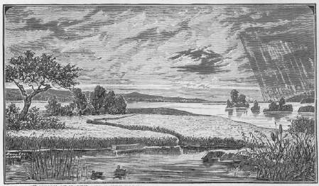
WATER COURSES.--The central and northern portions of the County are watered by the Platte River and tributaries, and the southern portion by tributaries of the Republican River. The North and South Forks of the Platte, flowing nearly parallel with each other and from one to four miles apart, unite and form the main stream near the center of the County.
TIMBER.--Small quantities of natural timber are found along the Plattes and in the canyons adjacent. No report of timber planted.
CHARACTER OF THE LAND.--About eighty per cent. of the area consists of rolling prairie and table land, and the balance of valley and bluff. The valleys of the Plattes are noted for the excellent quality of hay they produce, and for years past thousands of tons are annually put up on these rich meadows to supply the military Posts and country east of the mountains. The yield is from one to three tons per acre. The bluffs, canyons and prairies are covered during the entire year with the famous buffalo grass, affording the finest pasturage summer and winter. Large herds of cattle are wintered here without hay, grain or shelter. The County is admirably adapted to stock-raising and dairy farming. Agriculture is as yet carried on to a very limited extent. No report of crops.
HISTORICAL.--The first permanent settlements were made in 1859, by Messrs. D. L. Smith, W. S. Penniston, Thomas French, Patrick Mullaly, J. P. Boyer, A. J. Miller and others, who located along the Platte, on the overland road.
To accommodate the immense travel to California and the gold fields of the Territories of those days, numerous ranches were established along the main thoroughfare in this County, on the south side of the Platte, and until the completion of the Union Pacific Railroad, they did a very profitable business. Every settler turned his house into a hotel for the accommodation of travelers, and no attention whatever was paid to farming, beyond the cultivation of an acre or two of corn, and perhaps a small garden of vegetables. The majority of the ranches had large stores stocked with groceries, provisions, and wearing apparel. The Indians were troublesome, continually annoying the ranchmen by stealing stock and committing all sorts of depredations, and in 1864 the settlers were all driven from their
28
|
434 |
|
homes, their ranches burned, stock captured, and in many instances entire families were wiped out of existence by these savages.
The general election for the organization of the County was held in September, 1866, and resulted in the election of the following officers, viz.: Commissioners, W. M. Hinman, J. C. Gilman, J. A. Morrow; Probate Judge, Chas. McDonald; Clerk, Chas. McDonald; Treasurer, Hugh Morgan; Sheriff, S. Baker.
PUBLIC SCHOOLS.--Number of districts, seven; school houses, ten; children of school age, males, 361, females, 392, total, 753; whole number of children that attended school during the year, 397; number of qualified teachers employed, thirteen; value of school houses, $12,400; value of sites, $2,172; value of books, etc., $250.
TAXABLE PPOPERTY.[sic]--Acres of land, 73,136, average value per acre, $1.18; value of town lots, $143,151; money invested in merchandise, $34,195; money used in manufactures, $7,757; horses, 1,351, value, $32,621; mules, sixty-nine, value, $1,825; neat cattle, 40,364, value, $241,727; sheep, 5,307, value, $6,295; swine, 146, value, $350; vehicles, 238, value, $4,827; moneys and credits, $10,034; mortgages, $19,560; furniture, $18,727; libraries, $1,065; property not enumerated, $112,560; railroads, $601,228; telegraph, $4,930; total valuation for 1879, $1,327,036.
LANDS.--The Union Pacific Railroad Company owns thousands of acres of land here, for which $2 to $6 per acre is asked; the balance is nearly all Government land.
POPULATION.--There are six Precincts in the County, the population of each in 1879 being as follows: North Platte, 1,593; Brady Island, 72; Gannett, 23; Cottonwood Springs, 178; O'Fallon's, 65; McPherson, 86.
Total population of County, 2,017--males, 1,130; females, 887.
The County Seat, was laid out in the fall of 1866, by the Union Pacific Railroad Company. It is 290 miles west of Omaha, and is located near the center of the County, on a peninsula about three miles from the forks of the Platte. It is the terminus of the first division of the U. P. R. R., and here the Company have erected extensive, well-built brick shops, a round-house with twenty stalls, blacksmith, machine and repair shops, and a fine hotel.
|
|
435 |
The first building on the town site was put up in 1866, by Messrs. Penniston & Miller, who stocked it with goods to sell to the crowds who were flocking to the then terminus of the railroad. With the advent of the railroad came a motley crowd of laborers, business men, gamblers and roughs. All law, for the time being, was disregarded, and gambling and rowdyism ruled the day. This state of affairs lasted till June, 1867, when the terminus of the road was changed to Julesburg; and with this move, North Platte, which had at the time about 2,000 inhabitants, was nearly depopulated--only some twenty remaining. Early in the fall of 1867, the Railroad Company erected their round-house and numerous other buildings here, since which time the growth of the town has been steady and uniform, and in 1879, the population was about 1,600. The first newspaper, "The Pioneer on Wheels," was started in 1866. At present there are two flourishing weekly newspapers published here--the Republican and the Nebraskian. The Court House cost $22,500, and an elegant school building, which is supplied with all the modern conveniences and apparatus, cost $17,000. The Knights of Pythias have a fine building, worth about $8,000, which is used for Lodge rooms and general business purposes. The Masons, Odd-Fellows and Good Templars have well fitted up Lodge rooms, and hold regular meetings. The Episcopalians, Unitarians, Baptists and Catholics have Church buildings of their own; and the Methodists and Presbyterians each have organized Societies and resident ministers, and recently erected Churches. There are several general stores, two grocery, two drug, and two jewelry stores, a confectionery, liquor, flour and feed, hardware, furniture, and millinery stores, two blacksmiths' and two wagon-makers' shops, three meat markets, two lumber and coal yards, and a host of smaller establishments. The U. S. Land Office for this District is located here.
This city is the central point of the great cattle business of the Western Plains, and several of the most extensive dealers reside here with their families.
Is a station on the railroad, about twelve miles east of the County Seat. It is an extensive shipping point for stock, and transacts a
|
436 |
|
large business. A good wagon bridge across the Platte connects it with the settlements on the south side.
WARREN, BRADY ISLAND and GANNETT, in the eastern, and NICHOLS and O'FALLON'S, in the western part of the County, are stations on the Union Pacific.
Is a village on the south side of the Platte, in the eastern part of the County. It has a good general store and school house.
Lancaster County was organized in the fall of 1859, previous to which it was attached to Cass County, for revenue, judicial and election purposes. It is located in the southeastern part of the State, in the second tier of Counties west of the Missouri River, and is bounded on the north by Saunders, east by Saunders, Cass and Otoe, south by Gage and west by Saline and Seward Counties, and contains 864 square miles, or 552,960 acres, at an averge [sic] elevation of 1,114 feet above the sea level.
WATER COURSES.--Salt Creek, the principal stream, rising in the southern part of the County, flows southeasterly through the central portions, and furnishes an ample water supply for manufacturing purposes. It has numerous tributaries on either side, the most important of which are Haine's Branch, from the southwest, Middle Creek, from the west, and Oak, Little Salt, Gar, and Rock Creeks, from the northwest, and from the southeast, Stevens and Camp Creeks. Most of these streams are large enough for mill purposes, a good flouring mill with three run of stone being already erected on Oak Creek. The middle, eastern and southern portions of the County are drained by the headwaters of the Nemahas. Altogether the County is well watered, living streams passing through every township.
CHARACTER OF THE LAND.--The surface of the country consists chiefly of gently rolling prairie, about twelve per cent. being valley. Salt Creek valley, extending through the central portion of the
|
|
437 |
County, varies in width from two to five miles, and is exceedingly fertile and beautiful. Adjoining the smaller streams there are fine, level bottoms, and back from them the country is rolling, yet rarely too broken for tillage. In the southern portion of the County the surface consists largely of fine table land.
SOIL AND CROPS.--The surface soil is a black loam from one-and-a-half to three feet in depth. The area in cultivation in 1878 was 106,206 acres; in 1879, 125,800; increase, 19,591 acres. Bushels of winter wheat reported, 7,000; spring wheat, 700,000; corn, 1,000,000.
TIMBER AND FRUIT.--The streams are generally fringed with a fine growth of natural timber. There are, on an estimate, 4,000 acres of timber planted, 40,000 apple trees, 4,000 pear, 30,000 peach, 7,000 plum, and 10,000 cherry trees, a large number of grape vines, and 300 miles of live hedge. Wild fruit, such as the plum, grape, gooseberry, etc., grow in profusion along the streams. Many of the domestic orchards are in bearing.
STONE.--Magnesian limestone and sandstone are abundant in the County. They are easily worked and make an excellent building material, both having been largely used in the construction of buildings in Lincoln.
SALT.--The saline deposits of this County will one day afford the material for an important manufacturing interest. The great salt basin near Lincoln covers an area of twelve by twenty-five miles, the brine of which contains by weight twenty-nine percent. of pure salt.
HISTORICAL.--In the year 1856, several pioneers penetrated within the present limits of the County as far as the banks of Salt Creek, in search of future homes, though no permanent settlements were made until the following year.
The first permanent settlers, it is generally admitted, were John D. Prey and his sons, John W., David, and William, with his wife and daughter, who early in 1857, located at Olathe, on Salt Creek, about fifteen miles south of Lincoln.
Very soon after the settlement of the Prey's, Capt. Wm. T. Donavan located with his family and built a cabin, on the west bank of Salt Creek, near and west of the mouth of Oak branch, not
|
438 |
|
far from the Cahn artesian well. This was the first settlement in Lancaster County, as at that time bounded.
J. L. Davidson, W. W. Dunham, James Eatherton, Jeremiah B. Garret, J. C. Bristol, Solomon Kirk, William Arnold, Ogden Clegg, the Bogus Brothers, and Weeks, Haskins, and Palmer, joined the Preys at Olathe during the summer of 1857, and others took claims along the Upper Salt Creek, extending the settlement from where Hickman station now stands, on the A. & N. Railroad down to Saltillo. At this date, however, and down to 1864, this settlement was in old Clay County.
Shortly after Capt. Donavan's settlement near Lincoln, Wm. Norman and Alexander Robinson built a cabin near the present works on the Salt Basin, but left in the following spring. In 1857, also, John Dee settled on Camp Creek, near Waverly; A. J. Wallingford and his brother, Richard, pitched their cabins on Salt Creek, between Lincoln and Saltillo, and later the same year, Daniel Harrington, James Cardwell, and Abraham Beals, joined Dee at Waverly.
In the spring and summer of 1858, James Moran, John P. and L. J. Loder, and Michael Shea, settled at Waverly; William Shirley, Joseph Brown, Mr. Bottsford, J. D. Main, C. F. Retztoff, John Lemp, Aaron Wood and others, settled on Stevens Creek; Festus Reed, Jeremiah Showalter, and Joel Mason, settled south of the Wallingfords, and John Cadman, John Hilton and others, located near Saltillo.
The gospel was first preached in the County by Rev. Turman, of the Methodist Episcopal Church, at the house of Capt. Donavan, in the summer of 1858.
In 1859, Robert Farmer, J. J. Forest, and Joseph Gilmore settled at Waverly.
The first child born in the County was Morton Donavan, son of Capt. W. T. Donavan, on March 12, 1859. The boy still lives, and in 1867 had the honor of breaking the first ground for the Capitol building at Lincoln. Six days after the birth of Master Donavan, the wife of Michael Shea, on Camp Creek, gave birth to a son, and immediately afterwards a child was born to Wm. Shirley.
|
|
439 |
In the fall of 1859, the first movement toward County organization was made. A public meeting was held under the "great elm" that stood on the east bank of Salt Creek, near the northwest corner of the present B. & M. R. R. depot grounds in Lincoln. A. J. Wallingford, Joseph J. Forest, and Capt. W. T. Donavan were appointed a committee to select a location for the County Seat, and they chose the present site of Lincoln, which was laid off and named Lancaster.
According to law, the Commissioners of Cass County ordered an election to be held in Lancaster County, on the 10th day of October, 1859, for the purpose of County organization. Said election was held at the house of Wm. Shirley, on Stevens Creek, and resulted in the election of the following officers, viz.: Commissioners, A. J. Wallingford, J. J. Forest, and W. T. Donavan; Clerk. L. J. Loder; Recorder, John P. Loder; Treasurer, Richard Wallingford. No record of this election or of the official proceedings of the officers are on file in the archives of the County, except the certificates of election and qualification of L. J. and J. P. Loder.
At the general election held on the 9th of October, 1860, at the house of W. T. Donavan, twenty-three votes were polled, and the following County officers elected, without opposition: Commissioners, J. J. Forest, A. J. Wallingford, W. T. Donavan; Clerk, J. P. Loder; Treasurer, R. Wallingford; Justices of the Peace, Festus Reed, and R. Wallingford; Constables, C. F. Retztoff, and James Coultard.
The settlement of the County from 1859 to 1863 was very slow. The records of the elections of 1860-1 show no apparent increase in numbers. But the passage of the homestead law in 1862, gave a great impetus to emigration. The first homestead entry in Lancaster County under this law, was made by Capt. Donavan, just east of the site of the Insane Hospital, at Lincoln, on January 2, 1863.
In the summer of 1863, Elder J. M. Young and others, representing a colony, selected a site for a town which embraced the old town of Lancaster, then destitute of inhabitants, and which still belonged to the Government. Jacob Dawson and John Giles took homesteads adjoining the site. In 1864 Elder Young and


© 1998, 1999, 2000, 2001 for NEGenWeb Project by Pam Rietsch, T&C Miller