ASHLAND HIGH SCHOOL BUILDING, SAUNDERS COUNTY.
|
540 |
|
The County Seat, occupies the site of a former Indian town, upon beautiful ground between the Wahoo and Sand Creeks, and is near the geographical center of the County. It was made the County Seat in the fall of 1873, and was then a village of only a few houses, since which time its growth has been most remarkable, it now being a city of the second class, with a population of 1,250. The Omaha and Republican Valley Railway was completed to Wahoo in the fall of 1876. The United Presbyterians, Reformed Presbyterians, Catholics and Baptists, have comfortable Church buildings here. The Methodists, Congregationalists and Lutherans hold regular services. An elegant Court House was erected in 1874, and a fine school house, accommodating a graded school, in 1875. Business is generally well represented, there being two flouring mills-one steam and one water-power, two weekly newspapers--the Times and the Independent, three grain elevators, three lumber yards, three hotels, one bank, eight general merchandise, three grocery, four hardware, four drug, two furniture, three harness and three shoe stores, five agricultural implement dealers, thirteen lawyers, six doctors, three brokers, numerous mechanics' shops, etc. Among the Societies represented here are, the Masonic, Odd Fellows, Knights of Honor, Grand Army of the Republic, Sons of Temperance, Merchant's and Business Men's Club, and Bohemian Benevolent. Near the city are the Fair Grounds, with an extensive floral hall, stables, and an excellent half-mile track.
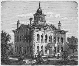
Located in the southeast corner of the County, on the line of the Burlington and Missouri Railway, has 950 inhabitants. It is beautifully situated on both sides of Salt Creek, about two miles from its junction with the Platte River. Ashland is the oldest town in the County, and was until 1873 the County Seat. Archibald Wiggins located here in 1857, and was the first settler upon the town site. Samuel Hahn, Martin Hall and Wm. B. Warbritton, located here at an early period. Fuller & Moe erected the first frame building, in which they opened a store in the spring of 1863. During the same year Joseph Hume and a Mr. Border
|
|
541 |
built a dam across the creek and erected a saw mill. In 1864, Dennis Dean erected a large raw mill, and also a grist mill with one run of burrs. Ashland now contains two first-class flouring mills, one windmill manufactory, one machine shop, ten general merchandise, three grocery, two hardware, two drug, two book, two boot and shoe, two furniture, and three agricultural implement stores, five grain warehouses, one bank, two meat markets, stock yards, and numerous other business establishments. The Saunders County Reporter, an old established weekly newspaper, is published here. An elegant school house was erected in 1871, which, cost, with furniture, $16,500. There are four handsome Church, buildings in the city, viz.; Methodist (the first in the County erected,) Episcopal, Baptist and Congregational.
ASHLAND HIGH SCHOOL BUILDING, SAUNDERS COUNTY.
Is a prosperous and growing town of 350 inhabitants, located on the Omaha & Republican Valley Railroad, in the southwest corner of the County. It contains several stores, and transacts a large grain and stock business. The extension of the railroad between
|
542 |
|
Valparaiso and Lincoln is now about completed, and new dwelling& and business houses are springing up rapidly.
The first station on the Omaha & Republican Valley Railroad, in Saunders County, has a population of 200. Various branches of mercantile business are represented.
ALVIN and WESTON are small villages on the railroad, the former east, and the latter west of Wahoo.
Ithaca, Rose Hill, Ceresco, Bradford, Milton, Swedeburgh, Headland, Isla, Colan, Esteina, Sand Creek, Platteville, Clayton, Cedar Bluffs, Denton, Cedar Hill, Willow Creek, Rescue, Newton, and Chowder, are Postoffices in the County.
Sarpy County, named in honor of Col. Peter A. Sarpy, was organized by Act of the Territorial Legislature, approved February 7, 1857, previous to which it was a part of Douglas County. It lies on the middle-eastern border of the State, and is bounded on the north by Douglas County, east by the Missouri River, and south and west by the Platte River, which separates it from Cass and Saunders Counties, and contains about 275 square miles, or 176,000 acres.
WATER COURSES.--The Missouri River washes the eastern border of the County, and the Platte River, flowing in a general southeasterly course, the western and southern borders. The Elkhorn River empties into the Platte in this County, after passing through the northwestern township. Big Papillion River, a very fine stream furnishing sufficient water for mills, drains the eastern portion of the County, flowing in a general southeasterly direction into the Missouri. Little, or West Papillion Creek, a tributary of the Big Papillion, with its branches, drains the northern tier of townships. Numerous small creeks, having their rise in the central portions of the County, flow in a southerly course into the Platte, the most prominent being Buffalo Creek.
|
|
543 |
TIMBER.--There is a great deal of fine native timber in this County. Through the central portion, running from east to west, there are several large, beautiful groves, the varieties consisting principally of hardwood, such as hickory, oak, walnut, ash, elm, and hackberry. Considerable cottonwood, ash, elm, willow, and other varieties, are found along the Missouri bottoms and ravines adjacent; also in the Platte bluffs, and on the large islands of that stream. 872 acres of forest trees, and 131 3/4 miles of hedge fencing, are reported under cultivation.
FRUIT.--27,512 apple, 810 pear, 6,297 peach, 1,127 plum, and 4,305 cherry trees, are returned, besides 9,834 grape vines.
BUILDING STONE.--There is an abundance of the best quality of limestone in this County. Extensive quarries have been worked here for many years.
TOPOGRAPHY.--Twelve per cent. of the County is valley, and the remainder rolling prairie, with high bluffs skirting the rivers. The first mile or two westward from the Missouri, the surface is broken in wave-like ridges which gradually give place to gently undulating prairie, extending to the south and west until the wide bottoms of the Platte and Elkhorn Rivers are reached. The Big Papillion, in the eastern portion of the County, has a beautiful valley varying from two to five miles in width.
CROPS.--Area under cultivation, 43,521 acres. Winter wheat, twenty-five acres, 366 bushels; spring wheat, 7,440 acres, 85,782 bushels; rye, 792 acres, 8,418 bushels; corn, 27,786 acres, 1,062,210 bushels; barley, 937 acres, 20,171 bushels; oats, 5,576 acres, 266,633 bushels; buckwheat, eleven acres, ninety-five bushels; sorghum, 15 1/4 acres, 1,401 gallons; flax, five acres, fifty bushels; potatoes, 413 acres, 31,334 bushels.
Large quantities of hay are annually put up on the broad meadow lands of the County. The soil on the uplands is a rich loam, the same as in Douglas County, and is seldom less than two feet in depth.
HISTORICAL.--The Expedition of Lewis and Clarke reached the mouth of the Platte River on the 21st of July, 1804, and on the evening, of the 22d, it encamped on the beautiful plateau on which the old town of Bellevue now stands. In 1805, it is stated, Manuel Lesa, a Spanish adventurer, visited this site, and upon viewing
|
544 |
|
the magnificent panorama spread out before him, exclaimed with a burst of admiration, "Bellevue!" (or beautiful view), a name by which it has since been recognized.
In 1810, the American Fur Company established a trading post at Bellevue, and appointed Francis De Roin, Indian Trader, who was succeeded by Joseph Robideaux, who served a term of six years, when his place was supplied by John Carbanne, until superseded, in 1824, by Col. Peter A. Sarpy, the distinguished Indian Trader of the Upper Missouri, who continued in that capacity for about thirty years.
In 1823, the Council Bluffs Indian Agency, at Fort Calhoun, was removed to Bellevue, and included in its limits the Omaha, Otoe, Pawnee, and Pottowattamie tribes. In 1834, Rev. Moses. Merrill, a Baptist Missionary, erected a Mission House among the Otoes. Mr. Merrill died at his post in 1835, and was buried on the Iowa side of the river. In the fall of 1834, Samuel Allis and Rev. John Dunbar, under the direction of the Presbyterian Board of Missions arrived at the Agency at Bellevue, in Company with Major John Dougherty, Indian Agent to the Otoes, Omahas, and Pawnees. Messrs. Dunbar and Allis opened a school among the Pawnees, at Council Point, a short distance up the Platte River, and when that village was abandoned on account of the hostility of the Sioux, they returned to Bellevue, and taught the children of the Pawnees at the Agency.
General Fremont's exploring party stopped at Bellevue, in 1843, on their return from the West, when they sold their mules and wagons at auction, and then descended the Missouri in boats to St. Louis.
In 1846, Rev. Edward McKinney, acting for the Presbyterian Board of foreign Missions, selected a site on the southeast part of the plateau at Bellevue, for a Mission house and school for the Pawnees. The buildings were commenced in the fall of 1847, and completed in 1848.
In 1847, the Mormons, under Brigham Young, reached the Missouri River nearly opposite Bellevue, afterwards called Old Trader's Point, on their journey to Salt Lake, in a weak and destitute condition, but were relieved by the generosity of Col. Sarpy, who furnished them supplies, sheltered them from the storms of
|
|
545 |
winter, and in the spring crossed numbers of them over his ferry free of charge.
In 1849, the Nebraska Postoffice, at Bellevue, was established. This year, Col. Sarpy's ferry-boat from St. Mary's to Bellevue was constantly employed in crossing over gold-hunters on their way to California. In 1852, Major Barrows, Stephen Decatur, and others, projected a town organization at Bellevue, which seems to have existed only in name.
June 6, 1853, Rev. William Hamilton arrived with his family, and took charge of the Presbyterian Mission House. During this year, the Agency buildings and blacksmith shop were erected on the plateau south of the Mission lands, under the direction of Major Gatewood, Indian Agent.
On the 9th of February, 1854, the Bellevue Town Company, was formally organized, with Col. Peter A. Sarpy, Stephen Decatur, Hiram P. Bennett, George Hepner, James M. Gatewood, Geo. F. Turner, P. J. McMahon, A. W. Hollister, and A. C. Ford, as the original proprietors.
The 4th of July, 1854, was observed with much enthusiasm at Bellevue. An immense vine-clad arbor was erected near the Agency buildings; the Star-spangled banner floated in the breeze; and a salute was fired for each State in the Union, including one for the new Territory of Nebraska.
Bellevue has the credit of publishing the first newspaper in the Territory, which appeared on the 15th of July, 1854, and was entitled the Nebraska Palladium; Dr. E. Reed, editor and proprietor. It was printed at St. Mary's, Iowa, until the middle of November, 1854, when the office was transferred to Bellevue. Dr. E. N. Upjohn struck off the first paper, and Thos. Morton set up the first column of type. It died a natural death in April, 1855.
The first Claim Club north of the Platte River was organized at Bellevue, in the fall of 1854, with Judge William Gilmer, as President.
At the first Session of the Legislature, Bellevue was incorporated as a city. In the latter part of January, 1855, D. E. Reed was appointed Postmaster. The Postoffice was held at the Mission
35
|
546 |
|
House, where the Doctor's wife taught the first white school in the Territory.
Nebraska Lodge No. 1, of A. F. &. A, M., was instituted at Bellevue, in March, 1855, although meetings were held at the old trading post in 1854.
It was not until June, 1855, that the Omaha Indians left for their new reserve, about a hundred miles further up the Missouri. They were loath to leave their old hunting grounds, and expressed dissatisfaction with the Government in sending a weak and defenceless [sic] tribe of less than one thousand souls, to a country where they would be at the mercy of their hereditary foe, the Sioux, having thousands of warriors.
Hon. S. D. Bangs, in his Centennial history of Sarpy County, in speaking of Logan Fontenelle, the celebrated Chief of the Omahas, says: Logan Fontenelle was a half-breed, his father being French. He was educated in St. Louis, spoke English fluently, and was at this time about thirty years of age; of medium height, swarthy complexion, black hair, and dark, piercing eyes.
"In the middle of the summer of 1855, a procession might have been seen winding its way toward the old home of Logan Fontenelle, on the bluffs overlooking the Missouri, above the stone quarries at Bellevue. It moved slowly along, led by Louis San-so-see who was driving a team with a wagon, in which, wrapped in blankets and buffalo robes, was all that was mortal of Logan Fontenelle, the Chief of the Omahas. On either side the Indian Chief's and braves, mounted on ponies, with the squaws and relatives of the deceased, expressed their grief in mournful outcries. His remains were taken to the house which he had left a short time before, and now, desolate and afflicted, they related the incidents of his death. He had been killed by the Sioux on the Loup Fork, thirteen days before, while on a hunt with his tribe. Having left the main body with San-so-see in pursuit of game, and while in a ravine that hid them from the sight of the Omahas, they came in contact with a band of Sioux, on the war-path, who attacked them. San-so-see escaped in some thick underbrush, while Fontenelle stood his ground, fighting desperately, and killing three of his adversaries, when he fell, pierced with fourteen arrows, and the prized scalp-lock was taken by his enemies. The Omahas
|
|
547 |
did not recover his body until the next day. It was the wish of Col. Sarpy to have it interred on the bluffs fronting the house in which he had lived, and a coffin was made which proved too small without unfolding the blankets which enveloped him, and as he bad been dead so long this was a disagreeable task. After putting him in the coffin, his wives, who witnessed the scene, uttered the most pitious [sic] cries--cutting their ankles until the blood ran in streams. The impressive funeral service of the Episcopal Church was read over the grave by Stephen Decatur."
On the afternoon of April 20, 1855, Geo. Hollister, a young man of considerable promise, while engaged in surveying on a high piece of ground overlooking Bellevue, was shot and killed by Dr. C. A. Henry. It appears that Dr. Henry and a man named Butterfield, had been out hunting along the Papillion that afternoon, and coming up with the surveying party, he had some angry words with Hollister in regard to claim lines, during which his gun was discharged, shooting Hollister in the abdomen, from the effects of which he died shortly after. Dr. Henry claimed that the shooting was wholly accidental, that the hammer of his gun caught in the heavy binding of his coat and was discharged. He gave himself up, and was confined in Sheriff Peterson's house at Omaha to await trial, but the grand jury failing to find an indictment against him, he was discharged. During the Doctor's confinement he frequently visited and prescribed for the sick of the city, in company with Sheriff Peterson, and upon his liberation he became one of Omaha's most active and influential citizens.
In January, 1856, the Mission Reserve was incorporated within the limits of Bellevue by Act of the Legislature, being a section of land reserved in the treaty with the Omahas to the Presbyterian Board of Free Missions, and for which the Government afterwards granted a patent. The Presbyterian Church was completed this year, and Rev. Wm. Hamilton installed as minister.
The Fontenelle Bank was incorporated in 1856, and transacted business at Bellevue until the financial crash of 1857.
During the year 1856, the Benton House was completed and kept as a hotel by Geo. Jennings, and the old Mission House was also converted into a hotel, known as the Omaha House, which was kept by Jos. Allen. A city organization for Bellevue was
|
548 |
|
effected by the election of Reuben Lovejoy, Mayor, and W. D. Rowles, J. T. Allen, and A. H. Burtch, Aldermen. The Young America newspaper figured about this time, but was short lived. It was succeeded by the Bellevue Gazette, edited by Hon. Silas A. Strickland, which launched its first number to the public October 23, 1856.
At an election held in November, 1856, Gen. L. L. Bowen, and J. S. Allen, were elected Councilmen of the election district, and S. A. Strickland, C. T. Holloway, John Finney, and Joseph Dyson, Representatives; and through their exertions Sarpy was set off from Douglas County by Act of the Legislature, approved February 7, 1857.
Messrs. Bowen, Holloway, and Strickland were the Commissioners appointed to locate the County Seat, and Bellevue was selected.
The first election after the organization of the County, was held May 25, 1857. Wm. H. Cook was elected Probate Judge; C. D. Keller, Register of Deeds; S. D. Bangs, County Clerk; W. F. Wiley, Treasurer; H. A. Longsdorf, Superintendent Public Schools; W. H. Harvey, Surveyor; John M. Enoch, Sheriff; and John B. Glover, Robert McCarty, and Philander Cook, County Commissioners.
At this election, Hon. Fenner Ferguson, of Sarpy County, having received the highest number of votes, was elected delegate to Congress. Judge Ferguson resided at Bellevue until his death, which occurred November 11, 1859.
The original town of La Platte, laid out in 1855, on the Missouri, between the Platte and Papillion Rivers; Papillion City, laid out in 1857, at a point about two and a half miles northeast of the present town of Papillion; and Plattford and Hazleton, towns organized at an early day, have long since been abandoned.
PUBLIC SCHOOLS.--The number of districts is thirty-six; school houses, thirty-five; children of school age males, 858, females, 706, total, 1,564; whole number of children that attended school during the year, 1,183; qualified teachers employed, males, twenty-eight, females, thirty; total wages paid teachers for the year, $8,800.10; value of school houses, $35,383; value of sites, $1,710; value of books and apparatus, $1,508.25.
|
|
549 |
TAXABLE PROPERTY.--Acres of land, 142,528; average value per acre, $5.17; value of town lots, $60,343; money used in merchandise, $15,954; money used in manufactures, $1,420; horses, 2,734, value $78,842; mules and asses, 165, value $5,369; neat cattle, 7,176, value $70,545; sheep, 438, value $247; swine, 11,013, value $11,357; vehicles, 701, value $13,817; moneys and credits, $12,724; mortgages, $19,017; furniture, $12,152; libraries, $115; property not enumerated, $36,450; railroads, $218,883.28; telegraph, $1,071; total valuation for 1879, $1,295,780.28.
RAILROADS.--Two railroads traverse the County, the Union Pacific, through the northeastern townships, a distance of 12.60 miles, and the Burlington and Missouri River, from north to south along the Missouri River, a distance of 10.99 miles.
LANDS.--Improved lands range from $8 to $35 per acre. The Union Pacific Railroad Company owns several thousand acres in the western part of the County for which they ask from $5 to $10 per acre.
POPULATION.--The following is the population of the County in 1879, by Precincts: Bellevue, 905; Papillion, 1,048; La Platte, 374; Forest City, 416; Richland, 496; Fairview, 622; Plattford 531.
Total, 4,392,--males, 2,431, females, 1,961.
The County Seat, is a prosperous town of 800 inhabitants. It is finely located on the Little Papillion Creek, in the northeastern part of the County, and is a station on the Union Pacific Railroad. The valley of the Papillion at this point is beautifully undulating and about a mile wide. The first building on the town site was erected in November, 1869, by Dr. D. E. Beadle, who also opened the first store in January following. The town site was surveyed and platted in January, 1870. Papillion is now an excellent market center, and contains several well stocked stores, a hotel, flouring mill, grain, elevators, etc., and an able weekly newspaper,--the Times, established in November, 1874. The Court House and school house are both handsome brick structures. There are five Church buildings, viz.: Methodist Episcopal, Catholic, Presbyterian, Episcopal and Baptist.


© 1998, 1999, 2000, 2001 for NEGenWeb Project by Pam Rietsch, T&C Miller