NEGenWeb
Project
Resource
Center
On-Line Library
Journals
NE History
& Record of Pioneer Days
Vol VII, no 1 (part 1)
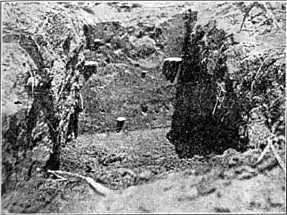
CROSS SECTION OF ANCIENT HOUSE WITH FLINT KNIFE
PROJECTING -- LOUP VALLEY
FIRST HISTORICAL SOCIETY RADIO
EXPLORATION OF ABORIGINAL REMAINS IN
LOUP VALLEY
By E. E. Blackman, Curator,
Nebraska State Historical
Society Museum.
(Radio broadcast from Omaha, Station WOAW, 6-6:30 P.M.,
September 13, 1924.)
The Region
The area which I explored in
July, 1924, is situated on a bluff or table land, 200 feet above
the Loup river level and approximately a mile from its banks.
The farm which is owned by E. J. Burkett of
Lincoln, is N. E. 29-17-4, in Nance County five miles S. W. of Genoa. I discovered
this site in 1902 and gave it a once over in 1907. Evidences found show this
ruin to be Skidi -- a band of the Pawnee tribe, which belongs to the Caddoan
linguistic family.
Practically every other ruin in Nebraska is
an Earth House ruin -- in the form of a circus ring, with a low place in the
center, having a raised bank of earth at the outer circumference. Settlers
called them "buffalo. wallows." This ruin is so different that it inspired
the study just made.
The house ruins here are mounds.
Some of these are still three feet high, after thirty years of
cultivation. J. W. Williamson, who lives at Genoa, rode over this
ruin in 1872 with Sky Chief, the head of the Skidi band. Many
mounds were five feet high. Sky Chief said the ruins were there
when his people came, that the Skidi would not live so far from
water. The creation myths cherished by the Skidi band as studied
by Dorsey, say the Skidi were created by the Great Spirit in the
Loup Valley.
The village ruins cover forty acres
on the level table land. The mounds are scattered without
geometrical design, being 200 to 300 feet apart each way. The
largest are still 3 feet above the level. The entire area is
thickly strewn with implements, broken flint, potsherds and
bone.
Grass House Ruins
These mounds are the built-up
floor of a grass house ruin. The Caddoan linguistic family were
originally grass house builders in their home in Texas. Coronado
saw the grass houses built by the Wichitas in Quivira, in 1541. He
said "they were like a loft where they kept their belongings and
slept." Every evidence shows these ruins to have been grass
houses. The cold winters in this area probably caused the Skidi to
abandon the grass house, because they built earth lodges later,
and this ruin was probably their first permanent abode in the Loup
Valley. Three miles from this ruin is an Earth House ruin,
probably made by the same people, later.
Excavation of Mound
I cut a trench through the
largest mound house ruin 2 1/2 feet wide, and 80 feet long. The
built-up floor was over 2 feet deep. I took out of this trench
over a hundred pounds of chipped flint, potsherds, bones, clam
shells and drift pebbles. This built-up floor was from 2 to 3 feet
below where the plow had disturbed the surface in cultivation, and
everything found was just where the aborigines had lost or thrown
it. Many perfect implements were found among the broken
pieces.
In some places this undisturbed
floor showed almost a polish, so hard was it packed by constant
use. In other places pure ashes as they were brushed from the
fire-place in the center, rested in thin layers at a slight
angle.
The entire mound is 80% ashes. They
were evidently poor housekeepers. And this five foot mound was
built up year by year. The ashes from the fireplace, the refuse
from the meals and implements, potsherds and pebbles were trodden
under foot and became a part of the floor of their grass house
abode. I found one of the finest flint knives ever seen,
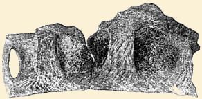
LOUP VALLEY POTTERY -- FOUND JULY, 1924
beneath this trodden floor - at the lowest level of moved
earth. The knife is 4 inches long and artistically made, of a
yellowish brown flint. Another perfect flint knife was found a
foot above this and three feet north of the first one. This is a
typical "Harahey" four-bladed knife - diamond shaped, with four
very sharp cutting edges. At the edge of the ruin - at the place
where the grass house sides came to the earth level, quite large
bones and large pieces of pottery were found. The earth around
these was loose, not being tramped hard as was the floor near the
fire place in the center. Here I found the large pieces of
pottery. A number of broken knives and small triangular "war
points" were taken from this trench. A few bone awls, buried in
ashes, were secured. One "chipping tool" of deer horn and a
polished bone bead were taken. One clam shell bead was found and
two bone knife handles well polished.
The Cache
On a point of bluff south of the village site and west of the
cemetery was quite a prominent mound having every appearance of
being a burial mound. It was 12 feet across the base and was
raised about two feet above the surrounding level. A cross-section
showed a cache, two feet at the top and 4 ft. 10 inches across the
level bottom. It was five feet deep. The sides sloped out like a
cistern, being bell shaped. The two foot opening at the top had
been covered with logs 4 inches in diameter. These had gone to
dust. These logs were supported on large buffalo bones set into
the solid loess soil at the opening or neck of the cache. These
bones' were very much decayed. This bell shaped cache was
excavated in the yellowish, loess soil of the hill and it was
completely filled with a very loose brownish dust. I removed all
this and exposed the firm, solid sides and floor of the entire
cache.
On the bottom was found a folded
leather or skin which went to dust on exposure. The entire
contents of the cache had never been touched by moisture and
appeared to be decayed corn or other stored material, which
through countless years has been in this cache, showing great
age.
Cornfields
Charred corn cobs were found near
the fire place in the house ruin. These were cobs of the typical
squaw corn. In the field of growing crop west of the ruin, may be
traced the outline of ancient corn patches. These corn patches are
from 30 to 100 feet square. They were separated by paths, worn by
footsteps, and blown by winds until the lack of fertility is shown
by poor and yellow vegetation - while the corn patch itself -
enriched by industrious squaws, show rank and verdant foliage.
These corn patches were easily traced in the growing crop. They
cover thirty or more acres.
Domestic Water
Supply
The well on the Burkett farm is
200 feet deep. There are no springs in the draws near. The Loup
river is a mile away. This seems an ideal strategic wartime
situation, on this high table land, but for an agricultural people
the situation is too far from a water supply. It is possible that
the domestic water supply may have come from artificial ponds or
lakes. This loess soil holds water when "puddled." Many splendid
ponds have been so made in Nebraska.
On the table land northwest of the
cornfields is an area of 30 acres or more which holds water; the
crop was ruined this year. C. R. Wright, who owns the farm west,
dug a ditch forty rods long and four feet deep to drain an area of
twenty acres on the high table land where the surface water in
rainy seasons ruined his crop. Artificial lakes may have been the
source of water supply, but this point is by no means settled.
The Flint Supply
There
are many tons of flint chips and implements on this ruin. Some of this flint
came from the Nehawka flint mines, 100 miles east; some came from the pink
flint quarries of Oklahoma, but more came from the Republican river valley.
These various kinds of flint are easily distinguished from the poor quality
of whitish yellow "Pierre Shale" which is in greatest abundance on this ruin.
This poor quality of chert crops out in various places along the 100th meridian,
and will doubtless be found not far away. Although diligent search failed
to reveal the sources of this flint supply. When the source of water supply
and flint supply are settled, we will know more of the history of this people.
Vol VI, no 4 


 Vol
VII, no 1, part 2
Return to NE History & Record
of Pioneer Days
Vol
VII, no 1, part 2
Return to NE History & Record
of Pioneer Days
© 2001 for NEGenWeb Project by Ted &
Carole Miller
© NeGenWeb