NEGenWeb Project
Resource Center OLLibrary

110

LEADING FACTS OF AMERICAN HISTORY

[1673-1679

muddy torrent of the Missouri, past the mouth of the beautiful Ohio. In about three weeks the explorers came to the spot where De Soto (§ 21) had crossed the river more than a hundred years before; then, pushing on, they reached the mouth of the Arkansas. There some Indians told them that the tribes below were hostile to strangers and that they had better return. Joliet and Marquette took their advice, got into their canoes, and patiently paddled their way back. Under the burning sun they battled for hundreds of miles against the powerful current; it was indeed a tremendous piece of uphill work.
   At last they reached the mouth of the Illinois; they worked their way up that river to an Indian village just below Ottawa,

JOLIET AND MARQUETTE

JOLIET AND MARQUETTE ENTERING THE MISSISSIPPI

and then made their way across to Lake Michigan. They had not followed the Mississippi to the Gulf, as they intended, but who will say that they had not made a good beginning?
   131. La Salle reaches the Mouth of the Mississippi. Six years later (1679) La Salle, the greatest of the French explorers, a man of active brain and iron will, set out from Canada to complete the work of Joliet and Marquette. On the Niagara River, not far above the falls, he built the first sailing vessel ever launched on the upper Great Lakes. In her he sailed to Green Bay; then, sending the vessel back for supplies, he and his companions went in canoes to the St. Joseph River,1 near the southeastern corner of Lake Michigan. (Map, p. 111.) There they built a fort; then, crossing over to the head waters of the Kankakee, a tributary of the Illinois, they descended that river to the point where Peoria now stands. There they built a second fort.

  1 La Salle paddled from Green Bay round to the St. Joseph River, Michigan.


1679- ]

LA SALLE REACHES THE MISSISSIPPI

111

Leaving a small garrison to hold this position, La Salle, near the end of winter, went back on foot to Fort Frontenac (now

map: THIRTEEN ENGLISH COLONIES

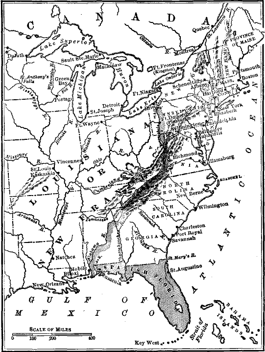
MAP SHOWING THE THIRTEEN ENGLISH COLONIES AND THE FRENCH
EXPLORATIONS AND SETTLEMENTS IN THE WEST

Kingston), on Lake Ontario, in eastern Canada. (Map, above.) He made that journey of a thousand miles to get the supplies which he needed for the exploration of the Mississippi.


112

LEADING FACTS OF AMERICAN HISTORY

[1681-1682

   While he was gone, Father Hennepin, a Catholic missionary in La Salle's expedition, set out from Lasalle Taking Possessionthe fort to explore the country. After many startling adventures he finally reached a cataract on the upper Mississippi, which he named the Falls of St. Anthony.
   When La Salle returned to Illinois (1681), he found his fort deserted and in ruins. But the brave Frenchman knew no such word as fail. In the autumn he set out on his great expedition for the third time. Landing at the head of Lake Michigan, where Chicago now stands, he crossed over to the Illinois and, going down that river, entered the Mississippi in February (1682). The weather was "bitter cold," and the river full of floating ice; but La Salle started with his company on his perilous voyage. Nine weeks later he reached the sunny waters of the Gulf of Mexico.
   There he set up a rude wooden cross, on which he fastened a metal plate bearing the arms of France.1 Then with volleys of musketry and loud shouts of "God save the King!" La Salle took possession of the vast territory watered by the Mississippi and the streams which flow into it. To that region of unknown extent -- twice as large as France, Spain, and Germany united -- he gave the name of Louisiana, in honor of

   1 Arms of France: a shield decorated with representations of the heads of lilies (here resembling small crosses). The latest French life of La Salle says he fastened the arms of France to a post and erected a cross beside it.


1701-1718 ]

FRENCH EXPLORATION

113

Louis XIV, then the reigning sovereign of France. So the "Grand Monarch," as he called himself, boasted that he held the heart of the American continent.
   132. The Founding of Mobile and New Orleans. Many years later John Law, an enterprising Scotchman, got permission from France to establish a colony in Louisiana. Law expected to find rich mines of gold and silver, and every needy and greedy Frenchman who could manage to scrape a few dollars together wanted to buy stock in the company. The speculation failed and made thousands beggars.
   Still the undertaking had some permanent results for good. A Frenchman named lberville had established a colony at Mobile, on the Gulf of Mexico (1701). His brother, Bienville, was appointed governor of Louisiana. It was hoped that he would send shiploads of treasure back to France. He sent nothing of the sort, but did far better, for he founded the city of New Orleans (1718). The settlement consisted of a few log huts built around a fort; it was destined to become the commercial metropolis of the great Mississippi Valley, -- a valley capable of producing food enough to feed all the civilized races of the globe.
   133. The English hold the Atlantic coast, but the French hold the interior of the country. Meanwhile, what had the English colonists in the East done toward exploring and occupying the country? Practically nothing. They simply continued to hold their first settlement on the Atlantic coast; in other words, the eastern edge of what is now the United States. The long range of the Allegheny Mountains, rising like an immense wall, seemed to hem them in.
   But the French, starting from Canada, had obtained a firm grip upon the interior of the country. They held the Mississippi, and with it they claimed to hold the great central West, extending from the Alleghenies to the base of the Rocky Mountains.
   What they held they meant to keep; La Salle showed that when he built forts at the most important points of his explorations, all the way down from the Great Lakes to the Gulf of Mexico. (Map, p. 111.)


114

LEADING FACTS OF AMERICAN HISTORY

[1689-1697

THE FRENCH AND INDIAN WARS (1689-1763)
   134. War with the French; Attacks on Schenectady, Haverhill, and Deerfield; the French lose Acadia. In Europe the French and the English had long been enemies. The desire of each to get possession of America did not make them any better friends. In 1689 war broke out between the rival colonists. With intervals of peace that contest1 extended over seventy years (1689-1763).
map: FRENCH AND INDIAN WARS

MAP ILLUSTRATING THE FRENCH AND INDIAN WARS (1689-1763)

In Europe the same war was fought between England and France, and it lasted even longer.
   In the first or "King William's War" (1689-1697) the French Governor of Canada sent an expedition of French and Indians to attack the colonies on and near the Hudson. They secretly came upon the little village of Schenectady, New York, at midnight. They burned it and massacred most of the inhabitants. But some Indians who made an attack on Haverhill, Massachusetts, met

   1 This war and those that follow were simply the American side of a hundred years' struggle waged in Europe and Asia, between the English and the French, for the possession of India and of the continent of America. See Seeley's "Expansion of England," Lecture II.

1697-1748 ]

TAKING OF LOUISBURG

115

their match. A small party of savages carried off Mrs. Hannah Dustin captive, intending to sell her as a slave in Canada. She got possession of some tomahawks, and with the help of another woman and a boy, also prisoners, she split the heads of the sleeping Indians, and carried home their scalps, ten in all, in triumph. A regiment of such women would have soon made both French and Indians beg for peace. During this war an expedition from Boston, led by Sir William Phips of Maine, captured the French fort at Port Royal, Acadia, now Nova Scotia, but it was returned to the French the next year (1691).
   In the second or "Queen Anne's War" (1702-1713) a party of French and Indians burned Deerfield, Massachusetts. On the other hand, the New Englanders recaptured Port Royal and named it Annapolis in honor of Queen Anne of England. They also undertook an expedition against Quebec, which ended in shipwreck and terrible loss of life. When peace was made (1713) the English not only kept Annapolis but got possession of Acadia, which they now named Nova Scotia.
   135. The Third War; Taking of Louisburg. There was a long interval of peace, and then the third or "King George's War" broke out (1744-1748). During this contest the New England colonists gained a remarkable victory. France had spent millions in fortifying Louisburg, on Cape Breton Island, so that it might guard the entrance to the Gulf and the River St. Lawrence.1 The fort was of immense extent and had walls of solid masonry thirty feet high. Colonel Pepperrell of Maine, with a force of a few thousand Yankee farmers and fishermen, set out to capture this great stronghold. The expedition seemed so foolhardy that even Benjamin Franklin 2 ridiculed it. Though himself a native

   1 France needed the fortified harbor of Louisburg as a shelter for her vessels, as a protection to her commerce and fisheries, and for maintaining free communication with Canada.
   2 Benjamin Franklin, born in Boston, 1706; died in Philadelphia, full of years and boners, in 1790. He was the son of a soap boiler and candle maker. He learned the printer's trade and went to Philadelphia, where, in 1729, he became editor and proprietor of the Pennsylvania Gazette. Later, he entered public life, went abroad as agent of the colonies, and rendered the whole country his debtor by his eminent services in the cause of American independence. The succeeding pages of this history will show that his name deservedly ranks with that of Washington as one of the founders of the United States. For a full account of him see "Benjamin Franklin's Life by Himself" (Ginn and Company].


Prior page
TOC
General Index
Next page

© 1999, 2000, 2001 for NEGenWeb Project, T&C Miller