NEGenWeb Project
Resource Center
On-Line Library
| Contemporary | 545 |
local "commons." When Highland Park was added to the city, Fountain Square was dedicated in the west end of town.
Columbus was laid out in additions and subdivisions. In the southern part of town, the Rickly and Speice tracts honor these two pioneers who did much to help in the settlement of the town.
Besides showing the growth of Columbus, the sub-divisions and additions to the original plat of Columbus are historical replicas which tell the story of realty, and the realtor's part in the promotion of his business.
THE ADDITIONS TO THE ORIGINAL PLAT
North of the Union Pacific Railroad tracks to Fifteenth Street and east of the Meridian Highway to Thirtieth Avenue are the Becker, and the Turner and Hulst sub-divisions.
From Fifteenth to Seventeenth Streets, between Thirty-third and Twenty-ninth Avenues is the Smith addition, and north of that, between Seventeenth and Nineteenth Streets, the Evans addition. Beyond that to the north is the Evans-lawn addition, which extends to Twenty-third Street or United States Highway 30.
East of Twenty-ninth Avenue to Twenty-sixth Avenue, between Sixteenth and Eighteenth Streets, is the Steven's addition and north of Nineteenth Street to Twenty-first Street is the Pearsall addition. The Becher place addition is east of Twenty-sixth Avenue to Twenty-second Avenue, between Sixteenth and Nineteenth Streets, and the Hockenberger addition from Fifteenth to Nineteenth Streets, between Twenty-second and Twenty-first Avenues.
Phillips has two additions from Nineteenth to Twenty-first Streets, and from Twenty-first to Twenty-third Streets, both lying between Twenty-sixth and Twenty-second Avenues.
Chamber's addition lies east from Twenty-first to Twelfth Avenues, and north from Fifteenth to Seventeenth Streets.
In the early 1940's, the East Park addition was added. It extends from Twenty-second Avenue to Eighteenth Avenue, the Monastery Road, and lies north of Seventeenth Street to Gottschalk's pasture. The Swift addition was opened for a new housing project in 1948 and lies east of Eighteenth Avenue and north of Seventeenth Street.
In West Columbus, the Highland Park Addition extends west from Thirty-third Avenue to Thirty-seventh Avenue, and north of the Union Pacific Railroad tracks to the middle of the block between Fifteenth and Sixteenth Streets.
The Gerrard addition extends north from the middle of the block between Fifteenth and Sixteenth Streets to Nineteenth Street, and lies between Thirty-third and Thirty-seventh Avenues.
The Oida Addition extends west from Thirty-seventh to Forty-first Avenues, and includes all land north of Union Pacific Railroad tracks to Fifteenth Street.
The Belmont addition lies north of Fifteenth Street and west of the "Y" Railroad track.
The famous "Capitol" Addition, supposed to have belonged to George Francis Train, extends west of Thirty-seventh Avenue to the "Y" Railroad track and from Sixteenth Street, north to Nineteenth Street.
THE STREETS AND AVENUES
The map of Columbus made by L. Frederick Gottschalk in 1925 gives the names of the streets which honored many of the pioneers and early business men who left their imprint upon the town.
Since 1920, when these street names were changed, Columbus has known neither east nor west in its numbering system. The city was then. divided systematically into avenues, numbers odd and even on either side of the street. In each residential block, a new number occurs at twenty-two feet intervals.
From Twelfth Avenue west the streets are numbered from the Avenues. Numbers 2 to 24 in each block occur on the right side of the street, and numbers 1 to 23 on the left side of the. street. From Twelfth Avenue west the Avenues are numbered from the street at the left and add fifty odd and even. The numbers at the left of each Avenue are 52 to 74, and on the right of each Avenue are 51 to 73.
Viewed from the air, Columbus looks like any other green-landscaped community in the middle of a sea of corn and grain fields. Its airport on the northeast edge of town, the broad transcontinental highways leading into it from the east, north and south, give the city a relatedness to the rest of the country which is implemented by the Union Pacific freight and passenger cars passing through each day and the concentration of Union Pacific property on the main line.
OLD LAND MARKS
Today as we approach Columbus from the east and look to the right for old landmarks, we see across the section of the original house, farm buildings, and a few of the old cottonwood trees on the former John Browner farm, now the home of the Durkop family. At the top of the Reed Hill, the Loup River Public Power House looms large on the former Carl Rohde farm. At
| 546 | The History of Platte County Nebraska |
Elks Club
the southwest corner of the Browner section on Highway 30, the Walter Loseke farm has replaced the old Stewart home. Across the Highway to the left, the William Saalfelds have changed and modernized the Will Lockhart place. On the C. D. Evans land are the Roselawn Nursery and the Roselawn Cemetery. To the right, the new home of Ira Betterton, and farther to the west, the St. Mary's Hospital farm. The old Zinnecker Road at the left meets the Fifteenth Street Road, a half mile to the south at the gateway of the former James C. Browner farm.
The Browner Farm is now the Platte County Agricultural Park -- a gift to Platte County by Mrs. Albert H. Gehner and Theodore Friedhof. The Platte County Agricultural Society has added many stables and a race track to the original modern farm buildings for the use of race meets, agricultural and stock shows, and the annual County Fairs. Here, in the 1940's, old fashioned song fests were held before the opening of the races, and the riding club led the stock parades at the opening of the County Fairs.
In the distance, beyond the Union Pacific Railroad tracks, lies the Columbus Cemetery, formerly a part of the original Jacob Louis Claim. The old cemetery was platted and its association organized in 1864, by a group of Columbus pioneers.
To the left of the Fifteenth Street Road is the St. Bonaventure Cemetery, whose beautiful landscaping was made possible by the gift of Mrs. Albert H. Gehner, the daughter of John Browner.
On Fifteenth Street to the right is St. Mary's Hospital, established in 1879 by the Franciscan Sisters of Lafayette, Indiana. Across Sixteenth Avenue to the west stands the old Franciscan Monastery, started in 1877, and to the north, the St. Bonaventure's Church. Across the street is the St. Bonaventure's School started in 1878. Its present order of Franciscan Nuns have conducted the school since 1882.
To the right, northeast of the city limits, on the Fred Gottschalk homestead, lies the new industrial district where smoke-stacks and great modern factories proclaim the growing importance of Columbus as a manufacturing and processing center.
At the left of the Monastery Road was the Jim Reed sheep ranch, and across the United States Highway 30, to the north, the site where the Columbus Township Hall was located for many years.
At Twenty-third Avenue and Twentieth Street is the Grace Episcopal Church, which was moved from its former site at Fourteenth and North Streets, in 1940, to make a place for the beautiful Loup River Public Power Building.
To the west of Twenty-third Avenue, between Thirty-first and Thirty-second Avenues on Eighteenth Street, stands the Lutheran Hospital, built and started in 1920 as the Evans Hospital by Doctor C. D. Evans.
| Contemporary | 547 |
Y.M.C.A. Building |
At the corner of Twenty-fourth Avenue and Fourteenth Street is the Immanuel Lutheran Church and to its north, the-Parochial. school. The original congregation was organized in 1883, by the Reverend Herman Miessler.
Two blocks farther east on Fourteenth Street is the most beautiful Elks Club in the west. The building was the home of Doctor Carroll D. Evans and was sold to the B.P.O.E. in 1938.
Passing over what Columbus early residents referred to as "the prairie land," we see Frankfort Square marking the modern unofficial center of town. From Thirteenth Street and Twenty-fifth Avenue, formerly known as North Street, the business district stretches in either direction with its string of independent and chain stores, its office buildings, and banks. The impressive structure of the Loup River Public Power District building is in block 49, across from the modern functionally designed Consumers Building. Two blocks away stands the Union Pacific freight and passenger depots. Columbus has two motion picture houses and a new outdoor theatre on the outskirts of town.
Just north of the Consumers Building, we see the library, built through the contributions of local citizens and the Carnegie Foundation. But it is in Frankfort Square that the recreational life of the community focuses and, like the Boston Commons and the "plaza" of Spanish towns, the square is the meeting place of public and patriotic rallies, the summer home of Columbus weekly band concerts, held in its modern bandstand, and the nucleus of the little settlement that was once founded by thirteen men.
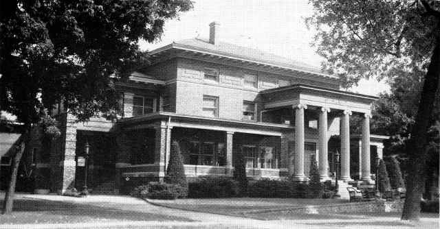
Across the street from the square is the Platte County Courthouse, serving the entire area of Platte County. To the west of the courthouse is the Y.M.C.A. Building, which the Sheldons, both C. H. and his son C.C. did so much to make a reality in this local branch of a great international organization.
West of Frankfort Square, at the location of Milton Galley's pressing and dry cleaning establishment in the 1940's, was the town's early medical building, which belonged to Doctor Carroll D. Evans.. Through the years, some of the most prominent Columbus doctors maintained their offices there. At one time, it was the medical offices of Doctors Martyn, Evans, Geer, and Hansen.
At the southwest corner of Thirteenth Street and Twenty-seventh Avenue, now the location of Schweser's store, was the site of the old Bonesteel Drygoods Store*, which in later years belonged to Theodore Friedhof.
Across the modern viaduct and over the Union Pacific Railroad tracks, we see the Wagner place, owned by August Wagner, the Wayside Country Club, and Pawnee Park. They occupy what was once the prairie land broken for farming by the early pioneer farmers.
Several acres of this land in later years came into the hands of the Monroe sisters, of New York, and J. D. Stires owned the Stires Farm, which ran east to Thirty-third Avenue, and to the west included the M. H. Van Berg place.
Flying past along the north bank of the Loup River, we pass over the site of the old Town Herd Pasture. This was where the family milch cows were herded by a herd boy during the daytime and driven back to their homes each evening. The times have changed and this business is now replaced by modern dairies.
Farther east on Sixth Street were the early homes of Charles Wake, John Browner, and Charles A. Speice. The latter is the site of the St. Anthony's Church, parochial school, and Sisters' Convent.
A block farther east, beyond the church, is Buffalo Square, near the original site of the Old Town Company House, erected in the autumn of 1856. Near there, John Wolfel built his home, an old log house, which stands today in Pawnee Park.
The Columbus Brewery, owned by George Rambour and his sons, Louis and Walter, occupies the original site of the Bremer Brewery, started around 1866, by Charles Bremer.
At the right is the Anderson Greenhouse, established by A. C. Anderson, and owned by his sons, Alfred and Oscar.
To the left, at Sixteenth Avenue on Eighth Street, was the old Wells' home, later the home of Adolf Jaeggi, now occupied by the Walter Jaeggi family. To the right, near Seventeenth
*Brothers Norris G. and Phillip B. Bonesteel.
| 548 | The History of Platte County Nebraska |
Avenue, was the home built by H. P. Coolidge in the early 1870's. It is now the home of S. S. Levine.
A block farther to the west, to the left, was the old home of Judge and Mrs. W. N. Hensley. Between Eighteenth and Nineteenth Avenues, at 1802-1812, was the site of the first school building erected for that purpose; and across the street, the St. John's Catholic Church, the first church in Columbus.
The First Ward School was moved to its site on Ninth Street around 1874, when the first brick building was built. The St. John's Church was moved to the block west of the First Ward School house, between Seventeenth and Eighteenth Avenues, around 1864, where a frame church was built during the pastorate of Father William Kelly. This block was later the home of F. G. Stenger and following that was divided into lots and sold for residences.
Across Ninth Street, south of the First Ward School, was the old home of Vincent Kummer, now the Harms' home.
At the southwest corner of Seventeenth Avenue and Ninth Street is the M. Brugger home, which has been occupied by the Brugger family since 1887.
Farther west were the homes of August Boettcher and William Bucher. The latter is now the home of Mr. and Mrs. A. D. Becker.
Two blocks to the south, on Nineteenth Avenue and Seventh Street, was the site of the Jacob Ernst, Sr. Blacksmith Shop, started in 1857, and later the home of Jacob A. Ernst.
The old Court House was located in Columbia Square, between Ninth and Tenth Streets. The Court House was moved to its present site at Twenty-sixth Avenue and Fourteenth Street when the new building was finished, in 1922. Through the years, the business district gradually moved north to Eleventh Street, and was followed by the First Episcopal Church, located at 2123 Ninth Street, the First Congregational Church, at 954-956 Twenty-second Avenue, and later occupied by the Baptist Church.
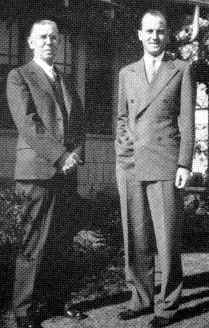
Samuel Gass, Jr., and Charles Samuel Gass |
The first high school was in the Congregational Church Building, and later moved to the Williams Building, in the Second Ward, which was finished around 1885.
The old Opera House, at Twenty-third Avenue and Tenth Street, was later the Orpheus Hall and then the Eagles Home.
Some of the names of the old business firms located on Eleventh Street in the days gone by were: Henry Gass and Company, William Bucher, Gustav Schroeder, Emil Pohi, August Boettcher, the Frischholz Brothers, the Greisen Brothers, I. Gluck, the Ernst Hardware Store, S. Bordy, Joseph Gutzmer, Henry Ragatz and Company, S. J. Ryan, Joe Ryan, Eimers, Hulst and Adams, Sam Kavich, Louis and Carl Kramer's store, the J. H. Galley Dry Goods Company, Von Bergen's Store, the Speice and North Coal Company, which later belonged to Carl Kramer, Vogel's Bakery, started by Marcus Vogel and later owned by his brother, Anton Vogel, and the Schreiber and Maier Blacksmith Shops. The latter still stands at the same location on Tenth Street, east of Twenty-fifth Avenue, and is operated by Louis Maier, Jr. and his son, Louis Maier, III.
The Marcus Vogel home was across the street to the west of the blacksmith shop. It is now the home of Anton Moschenross and family. The famed Grand Pacific Hotel occupied the site to the left, at 2519-2523 Tenth Street.
Other business houses through the years on Eleventh Street were the Marty and Merz Meat Markets, the L. H. Leavy, and Doctor Heintz Drug Stores, the Keating and Schram Grocery, in which "Mort" Murphy was once a partner. This store was later known as the Brunken and Haney Grocery, Hans Greiner's Store, and now the Gutzmer's Market. Others on Eleventh Street in the past included: the Rothleitner Hardware Store, Levine Brothers and A. Svislowsky Stores, and the J. F. Berney Implement Company, at the corner of Eleventh Street and Twenty-fifth Avenue.
The Berney Implement Company was followed in the same location by William Voss,
| Contemporary | 549 |
Carl Ewert -- Ewert Brothers -- August and Carl, and today, the George Ewert Implement Company.
As we fly over the Union Pacific Railroad tracks near Twenty-fifth Avenue, on our return to the airport, northeast of town, we picture the old Twelfth Street with its early business houses and the early Union Pacific Depot, which stood two blocks west and across from the Clother Hotel, now the White Hotel.
We also see the location of the early lumber yards, mills, and grain elevators, which were nearby. These pioneer companies are replaced today by the Hord and the Treadway Elevators; the Columbus Milling Company; the Mead, the Heynen, and the Viergutz Lumber Companies.
We realize that in each decade of the history of Columbus many changes have taken place in the business personnel and establishments of the town, until at the end of each twenty-year period, only a few of the names are found of people who were in established businesses twenty years earlier.
As the town grew northward hotels and stores were built north of the Union Pacific Railroad tracks, some distance from the original plat that marked the early boundaries of Columbus. In 1898 the second high school building was built on the north side of town. The junior and senior high schools in 1948 face one another across Murray Street.*
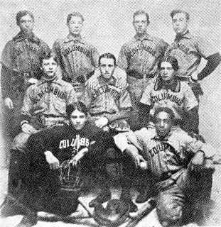
The Columbus Black Stars, an early baseball team. Top row: William Fent, third base; George Brodfuehrer, right field; Harry Lohr, short stop; Mark McMahon, second base. Center row: Louis SchonIau, center field; George Loshbaugh, first base; Roy McFarland, left field Bottom raw: Ralph Coolidge, catcher; James Jones, pitcher. |
It is in the Kramer High School auditorium with its seating capacity of seven hundred that the smaller local functions meet frequently. Larger groups, such as the "Friends of Music," lectures, conventions and other meetings are held in the auditorium of the City Hall. However, for softball and football games, the town gathers at Pawnee Park, across the viaduct to the west and next to the Wayside Country Club.
Many styles of architecture are evident in the community. Early frame dwellings still stand as mute evidence of the post-soddie stage when men built with their bare hands, using the elements at their disposal -- salvage logs and the very ground itself. However, in addition to the brick and frame two-story homes, of American, box-like style, English and Dutch Colonial, a new type design has become popular, introduced by the functionalism and attractiveness of the California ranch style house. Many of these, built all on one floor, may be seen in the newer residential districts flanked by the well-tended yards so characteristic of Columbus today.
There are trees, too, on the former prairie, for the men who had the courage and foresight to build a town knew that something was needed besides buildings and lots before a city became a place of pride and what was needed was beauty.
But its facilities are one of the features contributing to the importance of any urban community. The Columbus automatic telephone system was one step forward. When this was first instituted in March, 1931, the automatic communication by which subscribers could dial their number, marked a revolutionary change for the county seat. Almost twenty-five hundred cable pairs ran into the office from outside the building and eleven hundred lines of automatic equipment was furnished for the city alone. Rural service required additional facilities and for this the Nebraska Continental Telephone Company installed the latest apparatus in its new exchange building, built of twelve-inch solid brick walls.
Designed by Christensen and Nyquist, architects and engineers of Columbus, the building is outstanding as one of the more modern structures of the community and the efficient automatic system is administered locally by G. A. Klein, vice president and general manager of the company, and C. G. Fans, assistant secretary-treasurer. More than thirty-five telephone exchanges operate out of the company from its headquarters on the west side of Twenty-seventh Avenue opposite Frankfort Square. This is a
* In late 1949 this street was closed.
 |
 |
 |
 |
| © 2005 for the NEGenWeb Project by Ted & Carole Miller |
|||