|
By ALBERT WATKINS The object of early travel from the
Missouri river to the region beyond the Rocky mountains was,
first, exploration, as in the example of the expeditions of
Lewis and Clark, and Frméont (sic); second, trapping
and trading; third, the colonization of Oregon; fourth, the
reaching of the California and intramontane go d (sic)
mines; fifth, the transportation of soldiers and military
supplies for the protection of these enterprises from
hostile Indians. Prior to the period of transcontinental
railroad building there were several rival experimental
routes to the northerly part of those regions and, more
particularly, to Oregon; but the Platte river route, known
as the Oregon Trail, gained supremacy during the decade of
1830-1840, and held it until the opening of the Pacific
roads north of the first (Union Pacific) line divided the
traffic.1 The military department of the federal
government, including its engineers, had faith in the
superiority of upper routes while the general traffic
persistently preferred the Platte route. In this test native
instinct and experiment seem to have been wiser than science
unassisted by experimental knowledge. 1For an account of the evolution of the Oregon Trail see History of Fort Kearny, Collections Nebraska State Historical Society, v. 16; The Evolution of Nebraska, Proceedings of the Mississippi Valley Historical Association, 1909-1910, p. 126 et. seq. |
established leading from Walla Walla to Puget's Sound", but no action was taken upon this scant allowance. In subsequent appropriations the eastern terminus of the road was fixed at Fort Benton, which was forty miles below the great falls and practically the head of navigation, and also an important post of the American Fur Company. It was only in very high water that boats could run to a point a little below the great falls. On the 3d of March, 1859, the federal congress appropriated one hundred thousand dollars "for the construction of a military road from Fort Benton to Walla Walla", and another hundred thousand was appropriated for the same purpose by the act of May 25, 1860.2 Lieutenant John Mullan, of the Second artillery regiment, was detached to superintend the construction of the work.3 On the 31st of March, 1860, Pierre Choteau, Jr., of 2 United States Statutes at Large, v. 10, p. 603; 11, p. 434; 12, p. 19. Fort Walla Walla, situated contiguous to the city of the same name on the Walla Walla river, about thirty-five miles above its mouth, was established as a military post September 23, 1856. Whitman's mission, at Waiilatpu, five miles farther down the river, was established near the close of 1836. The original Fort Walla Walla, a post of the Northwest Fur Company (British), was established at the junction of the Walla Walla and Columbia rivers in 1818. Fort Benton was established in 1846 by Alexander Culbertson, as a post of the American Fur Company. On the 17th of October, 1869, it was taken over for a military post of the United States. A town was laid out there in 1864 (Report of Secretary of the Interior, House Executive Documents 1864-5, v. 5, p. 415). Trade and steamboat traffic fell off from the time that it became a military establishment; but they revived again in 1882-83. The river trade was destroyed and the town crippled by the advent of the Great Northern railroad. (Forty years a Furtrader, v. 2, p. 258, note.) 3 Lieutenant Mullan's regiment was already in Oregon on account of the Indian troubles. He received his instructions on the 15th of March, 1859, had organized his party and started from Fort Dalles on the 8th of June and began the work of construction on the 25th. (Senate Documents 1859-60, v. 2, doc. 2, p. 542; House Ex. Docs. 1859-60, v. 9, doc. 65, p. 108.) On the 19th of March the adjutant general of the army directed General W. S. Harney, then in command of the Oregon department, to provide Mullan's party with a military escort and supplies. (Ibid., p. 118.) |
St. Louis, contracted with Thomas S. Jesup, quartermaster, to transport from St. Louis to Fort Benton "about three hundred enlisted men, officers, servants, and laundresses, with their military stores and supplies, and to be paid one hundred dollars for each officer, fifty dollars per man, laundress, and servant, and ten dollars per hundred pounds for stores and supplies, including the subsistence of the men during the trip ".4 General order number 37, dated at the headquarters of the army, New York, March 31, 1860, directed the two departments of the recruiting service to organize, at Fort Columbus and Newport Barracks,5 four companies of recruits--two at each post--of seventy-five men each, "for the troops serving in the department of Oregon"; the recruits to be detached to Jefferson Barracks, near St. Louis, April 20th next; to move from St. Louis, April 20th, by the Missouri river to Fort Benton; and thence to Fort Dalles by the route being passed over by Lieutenant Mullan of the Second artillery; arrangements for transportation beyond St. Louis to be made by the quartermaster-general; the four companies to be armed and equipped as infantry at Jefferson Barracks and supplies to be obtained at St. Louis. Brevet Lieutenant Colonel Robert C. Buchanan, Fourth infantry, was assigned to the command of the recruits, but was superseded by Major G. A. H. Blake, of the First dragoons. Colonel Joseph E. Johnston, acting inspector-general of the army, afterward a con- 4House Executive Documents 1860-61, v. 8, doc. 47, p. 5. Lieutenant Mullan in a report of progress in the construction of the road, dated January 3, 1860, says (ibid., doc. 44, p. 33) that Choteau had agreed upon a price of thirty dollars per head for carrying the three hundred recruits; but this must have been an error. 5Fort Columbus was situated on Governor's Island, New York, and Newport Barracks in Kentucky, on the Ohio river, nearly opposite Cincinnati. 10 |
federate general of our sectional war, was ordered to inspect the recruits prior to their departure. 6 The official reports disclose the fortunes of the expedition up the Missouri river and also its exploration purpose. For many years after the introduction of steamboats to the Ohio and the Mississippi, the more rapid and changeable current, the ubiquitous sandbar, whose formations were more fickle even than political personal preference or public opinion, and the equally numerous and more damaging snags of the Missouri were the preclusive bugbear of steam, navigation. The first steamboat to tempt this triplex, obstruction and destruction was the Independence which started from St. Louis on the 15th of May, 1819, reached Franklin on the 28th, whence it proceeded as far as Chariton, about thirty miles beyond, before returning to St. Louis.7 6 The minor officers were Captains John H. Lendrum, Third artillery, and Delancey Floyd Jones, Fourth infantry; First Lieutenants August V. Kautz, Fourth infantry, La Rhett L. Livingston, Third artillery, John C. Kelton, Sixth infantry; Second Lieutenant Edwin H. Stoughton, Sixth infantry--to report at Fort Columbus, April 15; Captain Thomas Hendrickson, Sixth infantry, and First Lieutenants John T. Mercer, First dragoons, Benjamin F. Smith, Sixth infantry, George W. Carr, Ninth infantry, to report at Newport Barracks, April 15. (The Century, April 7, 1860, p. 79.) Brevet Second Lieutenants M. D. Hardin, C. H. Carleton, and J. J. Upham, of the Third artillery, Fourth and Sixth infantry, respectively, were assigned to duty with the recruits. (Ibid., April 14, 1860, p. 108.) Two detachments, two hundred and nineteen and one hundred and twenty strong, respectively, left Fort Columbus and Newport Barracks April 20. (Ibid., April 28, 1860, p. 164.) Brevet Second Lieutenant H. C. Pearce, First dragoons, was assigned to the detachment of recruits for Oregon. (Ibid., May 5, 1860, p. 189.) In the post returns of July, 1859, it appears that Lieutenant John S. Mason, of the Third artillery, was at Fort CoIumbus, New York, on general recruiting service. (House Executive Documents 1859-60, v. 9, doc. 65, p. 197.) 7 Franklin was situated on the north bank of the river, in Howard county, Missouri, two hundred and five miles, by the river, above St. Louis. Within a year after this demonstration of the practicability of steamboat navigation on the lower Missouri, Franklin became a very important and thriving place, as the initial and outfitting point of the Santa Fe trail. It held this monopoly for six or seven years, when the overland initial terminal was pushed up the river about one hundred and eight |
|
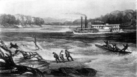
THE STEAMER YELLOWSTONE, ON APRIL 19, 1833.--From Portfolio of Maximilian Prince of Wied. |
It was the public purpose that the both famous and infamous Yellowstone Expedition of the same year should demonstrate the practicability of steamboat navigation to the far upper Missouri; but of the four boats that entered the river only one, Major Long's Western Engineer, was able to get as far as the Council Bluff of Lewis and Clark; though the next year one of these failing boats, the Expedition, reached the same point with a full cargo. In 1831 five steamboats made trips throughout the season from St. Louis to the settlements along the Missouri, Glasgow, successor to Chariton, and Boonville being the principal upper terminal points. By 1836 from fifteen to twenty boats were regularly engaged in this traffic. As early as 1829 a packet boat ran regularly to Fort Leavenworth. In 1831 the Yellowstone, built by the American Fur Company for the upper river fur trade, went as far as the site of the subsequent Fort Pierre in South Dakota, but it accomplished the latter part of the voyage only by much lightening and through the pertinacity of Pierre Choteau, Jr., who conducted the enterprise. The next season this boat reached Fort Union, at the mouth of the Yellowstone river. This was accounted a great triumph of transportation. Until 1845 an annual voyage of the Yellowstone to the same point was the limit of steamboat traffic to the high-up Missouri. In 1834 a boat had ventured as far as the mouth of Poplar river, about a hundred miles beyond the Yellowstone; in 1853, another--the El Paso--went a hundred and twenty-five miles farther--a little beyond the mouth of Milk river; and in 1859, the Chippewa, one of the trinity of our Oregon recruit expedition, went still farther, to a point about seventeen miles below Fort Benton, the acknowledged head of navigation. The Mormon immigration to the miles farther, to Independence, and Franklin rapidly declined. In 1832 the buildings were moved to a new location, two miles back from the river, which soon after carried away the original site. |
Missouri river, beginning in 1846, and its subsequent settlement in Utah; the resulting traffic to Utah augmented by the transportation of vast quantities of military supplies to the army sent there in 1857 and 1858 to suppress the Mormon rebellion; the emigration to Oregon and California which reached a great volume in the latter half of the decade of 1840-50, and the establishment of a chain of military posts in the interior to protect this traffic from hostile Indians; the development of a considerable fur trade in the lower Rocky Mountain region; and the political organization and resultant rapid settlement of Kansas and Nebraska had created by 1860 a heavy business for regular lines of steamboats to Leavenworth, Atchison, St. Joseph, Brownville, Nebraska City, Omaha, and Sioux City. As far, then, as Sioux City our Oregon recruit expedition traversed familiar, and on to the Yellowstone not untried, waters. The experimental features of the journey were the extreme upper reaches of the possibly navigable Missouri and the testing of the relative practicability of the two routes to Oregon. The official records of the war department tell us that, on the 3d of May, 1860, a detachment consisting of thirteen officers, two hundred and twenty-two enlisted men, under Major George A. H. Blake, of the First dragoons, left St. Loui for Oregon, via Forts Union and Benton and the wagon road commenced by Lieutenant John Mullan from Walla Walla to Fort Benton. "The detachment embarked on three steamers and the march was undertaken to test the feasibility of that route to Oregon." The march was successfully accomplished and the command kept in good health, except some fifteen cases of scurvy and other diseases. The sick soldiers were sent back from Fort Benton on the returning boats. The expedition arrived at Sioux City May 23, the water being very low; Fort Randall, May 27, where it met a temporary rise of water from rains, |
which facilitated progress; Fort Pierre June 2, noon, water very low again; mouth of Milk river, June 22; Fort Union evening of June 15; Fort Benton July 2, where the boats remained until August 2.8 The Nebraska City News of February 23, 1861, notes, in a steamboat itinerary of 1860, that the fleet passed that place on the 15th of May. The Omaha Nebraskian of May 19, 1860, noted the passage of the fleet in its characteristically breezy style: "On the 16th inst. a fleet of Steamers, consisting of the Spread Eagle, Key West and Chippewa, touched at this port on their way to the head waters of the Missouri--distant over two thousand miles. Each boat was crowded to its utmost capacity, with United States troops whose destination is Oregon, and the Territory of Washington. They will ascend the Missouri as far as navigable by the steamers above mentioned, and from thence will be marched across the Mountains to the forts of their destination. It will be remembered that this is the same route that the Nebraskian recommended to Oregon emigrants some two years ago, and it is a source of some gratification to know that our suggestions are properly appreciated by the general government, and to believe that this is destined to be the traveled route to one, at least, of the Pacific States. The trial trip was made by two of the boats mentioned, last season, in taking up a party of Government explorers. They then ascended the Missouri higher than any attempt was ever before made to navigate it, but we understand this fleet expects to ascend one hundred and fifty miles nearer the source of this mightiest of streams. The distance from the head of navigation on the Missouri, to the head waters of the Columbia, is only about three hundred miles. If the Mississippi be the "Father of Waters" it is not too much to claim that the Missouri, is at least the mother, the grandfather, the grandmother, the great-grandfather, the great-grandmother, numberless uncles, aunts and cousins, besides not a few poor relations." 8Senate Executive Documents 1860-61, v. 7, doc. 1, p. 131--report of the adjutant general, S. Cooper. |
 |
 |
 |
 |