position of its moneys, property, effects and affairs, subject to the constitution and by-laws. They shall elect a chairman of the board and the treasurer and secretary of the Society. The chairman shall sign all warrants of the Society. They shall have the power to elect a superintendent as the chief administrative head of the Society, and such other employees as they may deem necessary, and to prescribe their powers, duties and compensation. They may adopt such rules for the administration of the Society's affairs as they see fit, consistent with the constitution and by-laws. Regular meetings of the board of directors shall be held on the first Tuesday after the second Monday in January and quarterly thereafter during the year. At such meetings they shall receive reports from the secretary and other officers and employees, act on applications for membership, and transact such other business as shall seem to the Society's best interests. Special meetings of the board may be called by the president .or the secretary upon five days notice to each member, specifying the object of such special meeting. Five shall constitute a quorum of the board. The order of the business at a meeting of the board of directors shall be the same as that of the Society's meeting. Dated this 12th day of January, 1909. A. J. SAWYER, H. H. WILSON, After considerable discussion the report of the committee was adopted, and on motion of Mr. Geisthardt the by-laws were amended, as recommend by the committee in a former report.1 The following communication was presented by the secretary: The Daughters of the American Revolution of Nebraska propose to ask for an appropriation of $2,000 to mark the Oregon Trail across the State of Nebraska. This trail crosses fifteen counties and, judging by the number of markers required for the Santa Fe trail across Kansas, at least seventy will be needed across Nebraska. The D. A. R. of Kansas crossed twenty-two counties and put up eighty-nine markers, and patriotic societies and citizens placed six more. 1 See page 42.--ED. |
It is proposed to ask the county commissioners in each county to set these markers, leaving all of the appropriation which may be allowed for the purchase of the monuments. The Nebraska Daughters ask for the coöperation of the State Historical Society in their effort to secure the aid of the legislature and the county commissioners. The secretary moved that the Society pledge its cooperation in carrying out the plans of the Daughters of the American Revolution as outlined by Mrs. Letton. Seconded and carried. Mr. Harvey, chairman of the committee on marking historic sites, presented the report of that committee.
|
veyor-general of Nebraska for a contract, and in answer to a communication from the surveyor-general said that he was no more prepared to be killed by Indians than others, but thought it unlikely that he would suffer from their depredations as he intended to employ sufficient force to protect the party. Mr. Buck was awarded contract number 22, dated July 5, 1869, by Robert R. Livingston, surveyor- general of Nebraska, for the survey of the following lines, to wit: Fourth guide meridian west from the base line north to the first and second standard parallels, 48 miles. First standard parallel north from the third to the fourth. guide meridian, 48 miles. Exterior lines of townships 5 to 8 inclusive, of ranges 25 to 32 west, 312 miles, a total of 408 miles. The three-hundredth milestone on the base line west of the Missouri River, in Hitchcock county, is the initial point of the line first mentioned, and it runs between ranges 32 and 33. The first parallel above mentioned is between Hayes and Hitchcock, and Frontier and Red Willow counties. On July 21 the contractor writes to the surveyor-general from Ft. McPherson expressing regret that he did not procure arms at Plattsmouth and that he had made application to General Augur, commanding the department of the Platte, for six Spencer rifles, or "needle breech loaders," with 200 rounds of ammunition for each gun. He said that several members of his company were discouraged at reports about hostile Indians in his territory, and they wanted arms so that all could defend if they should be attacked. This is the last communication from Mr. Buck to the surveyor-general on file with the surveying records in the office of the commissioner of public lands and buildings. On October 2, 1869, Deputy W. E. Daugherty reported to the surveyor-general that having been unable to find Buck's lines he had instituted a search which resulted in the discovery of an old camp, a load of peeled stakes, evidently cut when the bark would peel freely; that he had traced Buck's wagon track about three miles to a place where he had camped on a creek two nights; and had found an abandoned water keg. This information was communicated to military headquarters, and a reconnoitering party, under command of Lieut. Jacob Almy, Fifth cavalry, spent some time in scouting on the Republican River and tributaries. Lieutenant Almy reported to his commanding officer that about August 20, when cherries were ripe, the Indians under Pawnee Killer and Whistler were moving from the Republican valley to Beaver Creek, crossing between Frenchman's Fork and Red Willow; that four young Indians were in advance and one of them returned and reported that the |
other three were killed by white men who were not soldiers, and that one white man had been killed. The squaws and children went into the brush and the men went towards the Beaver to fight. Returning at dark they reported that they had killed five more white men and destroyed two wagons. In August, 1869, I was employed in Mr. Allason's surveying party, and on the twenty-second, as we were traveling on the old Ben Holladay stage line from Fort McPherson to O'Fallon's Bluff, we were overtaken by a herd of cattle. Among the herders was a young man who, on learning who we were, informed us that he had recently quit Buck's party because it was so poorly armed; that it had been on the Red Willow looking for the monuments on the second parallel which we had established two months before, but had returned to McPherson for more arms.1 In 1871, I was employed by the land department of the Union Pacific Railroad Company to examine its lands in the Platte valley, preparatory to their being placed on the market, and while at McPherson got acquainted with a young man who was the keeper of the tollgate on John Burke's bridge over the north channel of the Platte river. In May of the following year, being still in the same employ, while examining land near Gibbon, Buffalo county, one afternoon, I took shelter from a rain storm in the shack of a young homesteader and remained there over night. I recognized in my host the keeper of the tollgate. He said that he belonged to the Fifth cavalry in 1869; was with the reconnoitering expedition which found the trail of Buck's party, and had traced it from the Republican to Beaver Creek; and that on crossing the table-land he discovered evidences of a running fight and the flight of the party, shown by the running of the teams over smooth ground and downhill. One wagon was found backed into Beaver Creek among some box-elder and willow bushes. My informant also said that his party found a number of dead Indians buried in tree-tops, but my recollection is that he said that no bodies of white men were found. W. E. Daugherty completed the survey of the important lines of Buck's contract; and in a footnote of his field notes he says that the Buck surveying party was massacred on the southwest quarter section 31, township 1, range 28, west. In 1872 this township was subdivided into sections by George W. 1 The young herder referred to by Mr. Harvey was H. B. McGregor. Mr. John F. Cordeal of McCook, Nebraska, discovered Mr. McGregor's post office address and procured from him a statement of facts. It follows this narrative, page 106.--ED. |
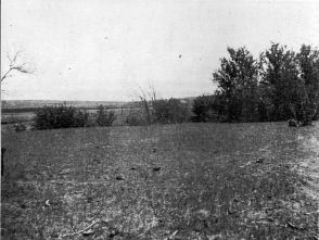
SUPPOSED SITE OF THE BUCK TRAGEDY. |
Fairfield, and at the southwest corner of section 31 of his map is found this statement: "Nelson Buck and party murdered here by Indians." In May of 1908, as state surveyor, I went to Danbury to make an examination of the line between sections 30 and 31, township 1 north, range 28 west which was in dispute between the adjacent landowners, and learned that it was at least a matter of local notoriety that the Nelson Buck surveying party was massacred in a bend of Beaver Creek in section 31, about half a mile south of the disputed line. After considerable inquiry I found an old man, Mr. John Conners, who settled on the Beaver near this place in 1873 or 1874, and he informed me that he found a number of bones in a bend of the creek and the running gear of a wagon in the creek behind some box-elder bushes, as though it had been run backwards into the stream, and that in after years a bone picker came along and gathered up the bones, some of which he was satisfied were those of animals and carried them away. From the quarter section between section 31 and 36, township 1 north, ranges 28 and 29, the stake shown at extreme left of picture bears s. 56 degrees 40 minutes e. 24 chains distant. A woman living on the next section, who he said was quite well educated and understood the anatomy of the human body, examined the bones and said that some of them were human. Mr. Conners pointed out to me the place where the bones lay and the box-elder bush behind which the wagon had been found in the creek. I drove a stake at the point indicated by him as the position of the bones and afterward determined its location in the section from the quarter section corner between sections 31 and 36. The bearing of the stake is s. 50 degrees 40 minutes e. 24 chains distant. A young man where I boarded took two views of the location with a kodak which show the stake, before mentioned, and myself standing in front of the box-elder bush. One of these views and a sketch of the creek with the bearing and distance from the quarter corner is herewith filed and made a part of this report. It will be noted that in the story, as above narrated, there is a continuity of the facts gathered from the different sources which could not well have been the result of collusion. It will also be noted that there is a disagreement in the opinion of the woman that some of the bones were human, and the statement of the young soldier, as I recollect, that his party did not find the bodies of any white men. This is emphasized somewhat by the statement of Mr. Conners that he never saw any human skulls among the bones. |
From the report of the surveyor-general I copy the names of the men engaged by Mr. Buck and who are supposed to have been killed:
I call attention to this event as being
the one great tragedy that befell an entire party engaged in
the survey of the public domain in Nebraska and as being of
sufficient importance and interest to be perpetuated by a
suitable monument.
|
tramp down the east side of the river until opposite Plattsmouth Nebraska then we were ferried across by a rope ferry to the Nebraska side and went into camp to complete preparations on this walk down the river we saw our firs [t] Indians camped along the river I was told they were Omahas & Pottawattimies & not--ugly. I had no communication with them and they paid apparently no attention to us. I do not recall just how many days we were at Plattsmouth but a week or two I recall I was there on July 4th 1869 & saw the party of notables drive the first spike in the R. R. then being run out there on that date--(Now the Burlington I believe) six more men were recruited while there four being about our ages, one about I should say twenty five (a scout) & one possibly 50 a teamster of them all I can only recall the name of the teamster Levi Minoslouski probably a Polish Jew with darkshort curls and Green eyes I never saw such before or since. We had but one wagon and team--It rained almost continuously & it was all the team could do to pull wagon and outfit so we all tramped; So far we had seen no Indians in Nebraska except a few Pawnees supposedly friendly. Jogging along ahead of the balance of our outfit McCulloch and I came upon a group of "dobe" Hovels one day (or sod Houses) and we learned we were at what was then known as "Grand Island Nebraska" south of the Platte (Old Gov. trail) Stopping at the nearest house I asked a motherly looking lady to sell us a glass of milk. We were invited in and given milk for which no pay would be accepted. Noticing a lot of Indian bead work moccasin [s], arrows, clubs etc., I asked for their history instantly this kindly lady became transformed into a raging tigress. Injuns, she screamed "I pisoned 'em seven of 'em & I wish I could the whole-----of 'em" they killed scalped and burnt my boy and I will kill 'em. anyway I can I put arsenic in my sugar for them and went away and left it for them thieving Pawnees to steal I got seven of them and their outfits.["] I began then to realize what Indian warfare meant for the first time no mercy by white or Red--but death by any means available on both sides. From Grand Island to Lincoln nothing of importance except continual rains and steady walking for us all, at Lincoln they were at work on the foundation of the state capital & I found a Mr. Crospey of Fairbury Ills there selling city lots the best $300 $25 down balance on long time & he told me homesteads could be had about 3 miles from Lincoln. From Lincoln to Fort Kearny nothing of interest one continual plod through rain and mud. Graves became more frequent however as we went west and a little board at the head of many simply said "killed by Indians" occasionally an arrow rudely cut in the board. I never saw a name on any of them |
but one and that had the single word "Comanches" roughly lettered on it. Rattlesnakes and Prairie dogs & some game became more numerous as we neared Fort Kearny also Grasshoppers by the millions big and little. It did not look to me like much of a country sand and sand hills--though the flat lands are fairly well grassed through which the trail ran; We arrived safely at Fort Kearny and were kindly treated by the C. 0. Major Pollock his officers and men. We camped and waited here some time officers and privates repeatedly warning us we would be killed if we ventured far poorly armed or without an escort. I know Mr. Buck made every effort to get arms and an escort but without avail from day to day and finally in despair he set out anyway supplies and money both getting low. ten days about after leaving the fort Mr. Buck told me to go back to the fort with John Nettleton & wait for the escort & arms & pilot them to the locality they were in as he was about in his territory and would begin running lines. We got into the fort all right and told our errand but there was nothing there. Nettleton hired out to the Platte Ferryman that day and I never saw him again though I learned afterward he got safely back to Illinois. I remained at the Fort for a time rations and a bunk being given to me Maj Pollock finally told me the Post trader wanted some one to drive an ox team to Plum Creek coming after wood--I took this job and drove the ox team back and forth making two trips each week for three weeks often at night hearing Indians crossing the Platte while lying in the grass but never seeing one. One man was with me all the time with another team of oxen I cannot recall his name but he was a prince of a man after my third round trip one of the Evans Bros of St Louis came along with a sutler outfit and I hired to him as a rider with his cattle outfit a large one if I recall correctly about 2600 head of cattle & about 60 people in all hearder scouts some of the scouts bore famous names Texas Jack--a lean sinewy taciturn man in Buckskins Wild Bill was another--Evans himself was a splendid specimen of manhood blonde bearded and erect on foot or in saddle--a big man in every sense of the word I should say 35 or 40 years old. While with the Evans outfit your Mr. Harvey met me one day and I told him as much of my story as I thought he cared to hear-- I don't suppose my subsequent adventures interest you they are many and varied. I met Mrs. Watson Nelson Buck's last living child yesterday. She has nothing new to say or show. March 17-1913. Two thoroughfares traversed the state, one on the north, |
|
RACHEL E. PATTERSON 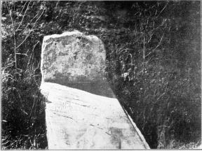
ORIGINAL HEADSTONE AND NEW HORIZONTAL SLAB. |
the other on the south side of the Platte river. These had branches on the two sides of the north and south forks of that great shallow Nebraska stream. Over these routes a stream of people travelled, which has been estimated at many millions, before the advent of the Union Pacific Railroad. There was untold suffering and sickness, and unnumbered deaths on these highways and graves marked every contiguous hilltop, valley, and the crossing of every stream. It may be said that the Platte valley which this route followed was one great graveyard from the Missouri river to the mountains. Erosion and waste have destroyed nearly all evidences of the burial places leaving only here and there a recognizable spot with a fragment of history. One of these is situated on a little "bench," on the west side of Ash Hollow, south of the North Platte river, Deuel county, Nebraska. It is the grave of a young woman who died there in 1849, and is marked by a small yellowish slab of native rock from the nearby ledge, and rudely shaped from a larger spall of Nature's chippings. The legend on its eastern face, skillfully cut by a relative or friendly hand, alone has saved the name of "Rachel E. Patterson" from oblivion. I visited Ash Hollow in 1869, and the little white upright slab drew my attention as I ascended the slope to find the graves of the two chiefs who were reputed to have been killed in battle with General Harney in 1855 and supposed to have been buried at the top of the bluff. I again visited the place in 1874, and, finding the slab still in position, I placed a row of small stones around he grave to further protect it from obliteration. On July 5, 1908, after thirty-four years, I again visited the grave and found the little slab still standing sentinel. The inscription was dimmer than when last seen, but still legible. It read, RACHEL E. PATTERSON Aged 18 June 19 1849 The stone is 18 inches high above
ground, 14 inches wide and 3 inches thick. |
The grounds are regularly laid out into lots and avenues. The two main avenues run north and south, east and west. At the east end of the east and west avenue is the Rachel Patterson grave. A stranger, Mr. Rittemer of North Platte, donated a marble slab forty-six inches long and fifteen inches wide and imbedded it in cement. On the upper surface of the slab is the following inscription: RACHEL PATTERSON who died and was buried here in 1849. She belonged to a California Emi- grant Co. from Missouri. Aged 18 Yrs. The grave is situated near the foot of
the slope at the edge of the bench and about fifteen feet
higher than the level of the cañon. |
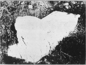
WEST FACE OF HEADSTONE. |
 |
 |
 |
 |