height of about forty feet above the level of the valley, and on the top is a flat surface, embracing four or six acres, which really seems as if nature had fixed that mound for the Capitol buildings of the Territory. The bill, re-locating the Capital, also named the place, which is "NEAPOLIS." Extensive improvements have already been made in the vicinity of Neapolis. Houses are being erected, prairie broken, preparatory to opening farms, and settlers are flocking in rapidly. A steam sawmill is in successful operation, having already cut out and sawed some 70,000 feet of oak and walnut lumber, and the appearance of things generally would lead one to suppose that the day is not far distant when "NEAPOLIS" will be called the "Queen City" of Nebraska. The Nebraska Advertiser of February 4, 1858, said: The commissioners were named in the bill, viz: S. F. Nuckolls of Otoe, W. D. McCord of Cass, John Finney of Sarpy, and Elisha N. Hamilton of Washington. They are to proceed at as early a day as practicable and locate within boundaries, from east to west, between the Guide Meridian and the Sixth Principal Meridian; and within six miles of the Platte river, on either the north or south side. The entire town site is to belong to the Territory; one third of the lots to be sold the first year, the proceeds of which are to be expended in the erection of suitable public buildings for the accommodation of the Legislature and Territorial officers. Nebraska City, watchfully waiting for a chance to capture the capital, naturally regarded the Neapolis project with disfavor. On February 20, 1858, The Nebraska News announced that, "Companies of enterprising gentlemen from Plattsmouth and Glenwood, have been out taking up lands near unto where the new Capitol is to be located. The issue of February 27 gave further particulars under the sarcastic headline, "Taken Up By Actual Squatters": It is truly gratifying to observe how the lands about the new Capitol of Nebraska are being filed upon by actual residents. On the 26th day of January, 1858--in one day, there were eighteen settlements made in township 17 range 7. By examining the Register's Books at this Land Office, we find, too, that the class of men who are about making farms |
there is a very superior class for the agricultural advancement of the Territory. Among those who filed on lands in town 17 range 7 on the 3rd day of Feb. we notice the names of those thrifty and energetic farmers and stern opposers of speculation, Columbus Nuckolls, on S. E. 1-4 Sec. 26; Hon. Edwin A. Donelan, on N. E. 1-4 sec. 26; Lowden Mullen, on S. W. 1-4 sec. 26. And then again we find that on this same 3d day of February 1858, Lafayette Nuckolls, William E. Donelan, Samuel H. Elbert, Samuel H. Moore and eleven others filed upon lands in this same township. lt gives us great pleasure to know that our inland country is to be taken up and improved by such energetic and worthy men. They will undoubtedly put down all speculation and such like abominations in that section of Nebraska. And we feel safe in predicting that the Capitol of Nebraska located on about the N. W. 1-4 of section 26 in township 17 range 7 would prove of great and lasting benefit not only to Hon. Edwin A. Donelan and many other patriotic members of the late Legislature, but to Nebraska, to the Union, and to the world. This is what the people require. They desire a Capitol located without fraud--located not for the benefit of speculative politicians and we see the present indications are good for this much desired result. Some persons have very unbecomingly hinted that from the names of the squatters above mentioned they should conclude that there was an African in the collection of fuel--vulgarly, "a nigger in the wood-pile." But we can assure them that their suspicions are ungenerous, and highly indecorous, for the absolute and determined intention to very definitely settle upon and improve these lands is fully set forth in their declaratory statements. We trust these settlers at the new Capitol will take warning from the sad experience of Omaha and learn at an, early day not to frighten the "animiles" nor in any way disturb them in their innocent amusements, lest they run away. In the year 1859, Samuel G. Daily contested the election of Experience Estabrook as a delegate to Congress from Nebraska Territory. In the course of the contest, on December 16, Robert Kittle, of Fremont, a well known pioneer, gave important testimony about the status of Neapolis as follows: I have been in Calhoun county, up and down the river |
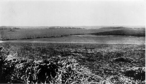
View from Capitol Hill Looking East. |
some eight or ten miles; there was a settlement there about two years ago of some ten or fifteen persons, close by the river, near a point which was then called Neapolis, about four or live miles northwest from the Pawnee village. I have been there several times since, and the houses or shanties which they had built were entirely torn down, and the people had left more than a year ago. I do not know of any other settlements now, or that have been made within a year in that county.24 On December 30, James L. Hindman, testifying in the same case, said that he had lived in Calhoun county from May to September, 1857, and again from May, 1858, to August, 1859. When I returned there in 1858, I found a settlement there called Neapolis, in the north part of the county in range 7 and 8, and township 17. The settlement was entirely abandoned in the spring of 1859--every settler left there. From fifteen to twenty men were there laboring and making claims; they all left that county.25 24 Miscellaneous Documents, first session thirty-sixth Congress, volume V, document 12, page 11. 25 Ibid., pages 75-76. Calhoun county was included in an act passed by the second territorial legislature, January 26, 1856, "to establish new counties and define their boundaries." (Laws of Nebraska, 1-3 Ter. Session, second session, page 201.) The fourth standard parallel was the northern boundary of the county, and the southern boundary was identical with that of the present southern boundary of Saunders county, except that in 1866 a strip six miles long and two miles wide was taken from Cass county and added to the southeast corner of Saunders. (Special Laws Eleventh General Assembly Nebraska Territory, page 607.) By the act of November 3, 1858, Calhoun county was extended northward to the Platte River by the addition of the fractional townships 17, in ranges 5, 6, 7, and 8. This fraction had belonged to the original Cass county, as designated by Acting Governor Cuming; it was assigned to Green and Lancaster by the first territorial assembly, in 1855; but from the time the boundaries of Calhoun county were defined, in 1856, until its addition to that county in 1858, it remained detached. (Laws of Nebraska, 4-6 Ter. Sessions, fifth session, page 397.) When the Republican party attained full power in the territory the names of three counties, Calhoun, Green, and Izard, which were offensive because they had been given in honor of southern statesmen, were changed, respectively, to Saunders, Seward and Stanton. (Laws of Nebraska, |
A remarkable elevation answering to the description copied herein from the Pacific City Enterprise, both in appearance and in distance from the river, is situated in the northeast quarter of the southwest quarter of section 23, township 17, range 7. In 1866, Ely Palmer settled on a farm which includes the high land in question, and he still owns it. Mr. Palmer says that when he came to this place there were stakes, marking a town site, cov- 7-10 Ter. Sessions, eighth session, pages 110, 115, 126.) The present Saunders county contains the same territory as Calhoun contained with the exception of the strip added in 1866. The report of the committee on elections, Daily vs. Estabrook, finds that Calhoun county "could have been organized," under 'an act to establish new counties, &c.,' "by the proper application to the county commissioners or probate judge (no matter which) of the nearest county on the east. But nothing of this kind was done. On the contrary, it was attached to the county of Platte for election purposes, and constituted a voting precinct of that county." It was the duty of the election officers to send the poll books to the clerk of Platte county. But even this was not done. "Instead of doing it they sent the returns directly to the governor, and they were taken out of the post office by his private secretary, who opened and examined them, and then sent them himself to the clerk of Platte county, with directions to return them with the Platte county returns. This was manifestly a violation of the law. The law of the Territory as also of all the states, has pointed out a particular mode of making election returns, and has designated particular officers who shall open and inspect them. If they are opened and inspected by any others they are thereby vitiated; for if such a practice were tolerated innumerable frauds might be perpetrated, and the popular will defeated." (Report of Committees, first session thirty-sixth congress, volume III, document 446, page 5.) But this would depend on motive and effect. The committee find a second reason for throwing out the alleged vote of the county. Contestant had proven by competent witnesses that the entire settlements of the county consisted of two families in the northwestern part and four in the southeastern part and the whole voting population was not over six. Yet 32 were returned, 28 for Estabrook and 4 for Daily. The returns had been abstracted from the office of the clerk of Platte county. The committee concluded that the returns were forged. The clerk of Platte county could find no record in his office of a Calhoun county voting precinct, and even the sitting delegate denied that it was so attached. |
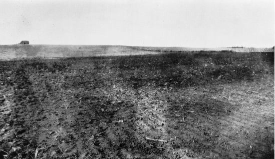
Capitol Hill Looking Wast. |
ering the forty acres described above. In a letter to the editor, dated May 18, 1914, the late J. J. Hawthorne, of Fremont, Nebraska, expressed the opinion that the site in question, still known as Capitol Hill, was so called because the commissioners who, in 1867, chose Lincoln for the capital, looked with favor upon it, and that Neapolis was on the high ground about two miles farther east. Mr. Hawthorne argues plausibly, in support of this opinion, that the sawmill would naturally be built close to the town for which it was designed to supply lumber--and it was situated on the river bank just below his preferred site of Neapolis, in the northwest quarter of the northeast quarter of section 29, township 17, range 8. He says that a town site called Buffalo was established, subsequently to the Neapolis incident, about a mile east of Capitol Hill, on land now included in the Jack Staats farm. The township plat, in the office of the commissioner of public lands and buildings, contains the boundary of Buffalo. It was nearly a mile in length, east and west, and two-thirds of a mile north and south. It lay chiefly in section 26--immediately south of section 23 which contained a part of the site of Neapolis-- but it extended eastward into section 25 about an eighth of a mile, and its north boundary was a little more than an eighth of a mile south of the line between sections 23 and 26. Moreover, the plat discloses that the township lines of this township were run in August and September 1857, and the subdivisions between September 25 and October 12, 1857; so that Buffalo was laid out a long time before the site of Neapolis was selected and was too far east to be mistaken for the capital site which Mr. Hawthorne thought was likely. This theory gave him opportunity to suppose that Neapolis was situated a mile farther east than Buffalo and so quite near the sawmill. |
Public records rudely shut the door against the fancy that the capital commissioners of 1867 flirted with Capitol Hill and incidentally or otherwise gave it the name. The capital removal bill of that year confined their search for a site to Seward county, the south half of Butler and Saunders and that part of Lancaster lying north of the south boundary of township 9. On the journey of investigation, the commissioners followed Salt Creek from Lancaster to Ashland. Thence, quoting from their report, 26 "we went northwesterly along the old California trail through Saunders county, crossing the Wahoo near its head, and arriving at nightfall at the residence of J. D. Brown, in Butler county." Mr. Brown's residence was on Oak Creek. The commissioners proceeded westerly to the north fork of the Blue and then southerly along that stream. They did not go farther north than township 14 which lies in the south half of Butler county. Thomas P. Kennard, one of the commissioners, says now (1914) that they had no reason for going as far north as the Platte river and did not go beyond the territory within which the removal act confined the location of the new capital. The comptroller of the treasury of the United States decided in the Oregon case that the members who met at Oregon City should be paid their per them allowance, but that those that assembled at Salem should not be paid; also that "no expense incurred by the members who assembled at Salem should be paid. Of course, their journals nor proceedings of any kind are to be paid for at the public, expense."27 The rule was followed in the Nebraska case, and apparently without dispute, since 26 Senate Journal 1869, page 300. 27 Executive Documents, first session thirty-second Congress, volume XII, document 104, page 9. |
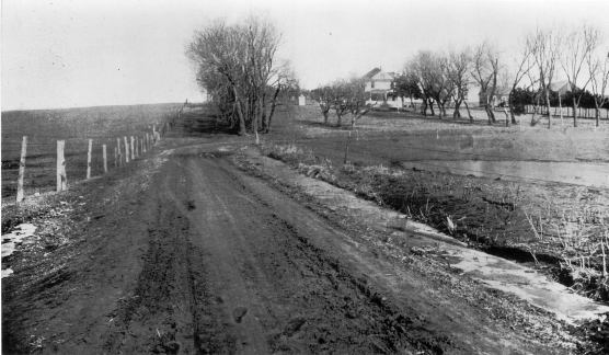
Ely Palmer Farmstead, South Slope of Capitol Hill. |
 |
 |
 |
 |