|
Legend
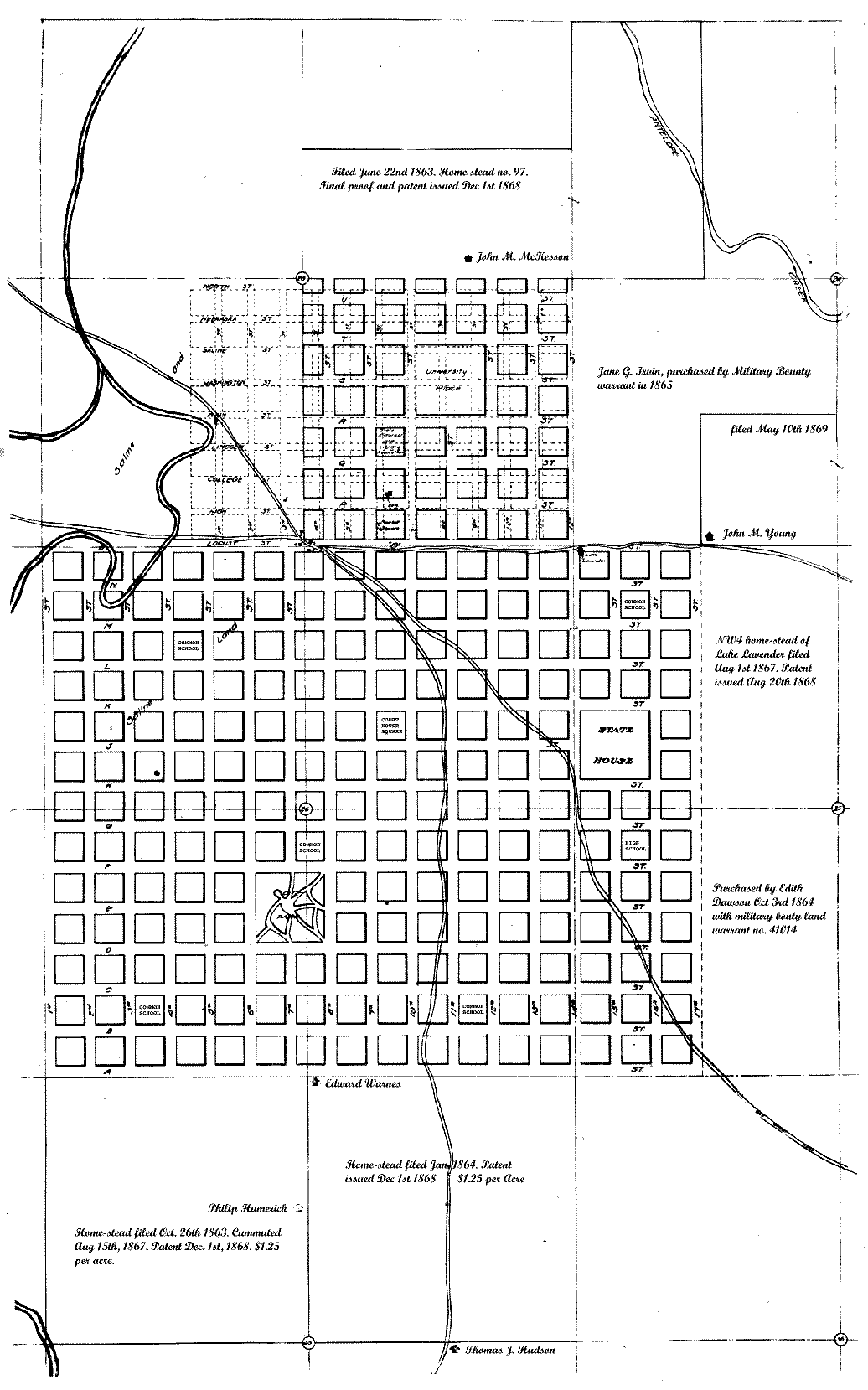
Stone monuments marked with a drill point are established at the intersections of the center lines of Fourth, Seventh, Tenth, Thirteenth and Sixteenth Streets, with all the streets running east and west and in A, E, J, O and S, with all the streets running north and south, also at the center intersections of Fifteenth and H, Fifteenth and K, Eight and P, Ninth and P, Eighth and Q, Ninth and Q, also in Seventh, Tenth, Fourteenth, at the intersection of the north line of the northern tier of blocks. These monuments are marked upon the plat thus: Third, Seventh, Ninth, Eleventh, Fifteenth, D, J, O, and S, are 120 feet wide, other streets are 100 feet wide; alleys are sixteen feet wide. Lots in the north half of blocks 46-261 inclusive, south half blocks 34-39-40-41, SE of 42, SW of 44 and south 1/2 of 45 are 25x142 feet. Lots 16-17-18-19-20-21 in block 53 and 13-14-1516-17 and 18 in block 54 are 23 feet and 8 inches by 134 feet. Lots in west half of blocks 42-69-86-101 and east half of blocks 44-70-85-102 and 117 are 25x134 feet. Lots in each half of blocks 17-22-122-125-174 and 193 and the west half of blocks 16-28-119-123-124-175 and 192 are 50x134 feet. All other lots are 50x142 feet.
The following blocks are reserved for public purposes, as follows
Block 43 for market house and city hall.
Blocks 63-81-163-219-227 for common schools.
Block 155 for high school.
Block 118 for county court house and three lot. in each of several blocks, (to be chosen by duly authorized persons) for the sterile. of churches.
The undersigned certify that the above description of the streets, alleys, blocks, lots and permanent comments and the accompanying plat are according to the field notes of the surveyor of the town of Lincoln and the said has been surveyed according to said notes to the best of our knowledge and ability.
Witness or hands at Lincoln, lots 26th day of August, A. D., 1867.
ANSELMO B. SMITH,
AUG. F. HARVEY,
Surveyors. |
Filed for record September 6th, A. D., 1867, at 10 O 'clock a. m.
S. B. DALEY, County Clerk.
S. B. LINDERMAN, Deputy.
Legend on original plat of the town of Lancaster:
Plat of the town of Lancaster, Nebraska, surveyed and platted August 6, 1864, by order of county commissioners.
The field notes are signed by Jacob Dawson, surveyor.
Field notes of survey of Lancaster town site, Nebraska.
Commencing at the southeast corner of section No. 23, town No. 10, north of range No. 6 east. Thence West on south line of said section leaving 33 feet or 112 chain on east side for street, to quarter post on said south line leaving 1/2 chain on west side for street, thence north to center of section 23, aforesaid minus 2 chains for street, thence east to quarter post on east side of said section minus 1/2 chain, thence South to place of beginning.
Thence proceeded to survey blocks running west numbered one, two, three, etc., 4 chains each and streets, 1 chain (66 feet) to block No. 8, thence east and west alternately to block No. 64, according to annexed plat. Alleys running east, and west 20 feet wide, lots north and south 8 in a block.
JACOB DAWSON,
Surveyor.
Field plat notes of addition to Lancaster. Said addition consisting of the cast 1/2 of the SW 1/4 of section 23, town 10, range 6, commencing at the southeast corner, laid off in blacks four chains and streets one chain wide. Blocks numbered from south to north, commencing at No. 65, running to No. 96 inclusive as par plat hereto annexed August 6, 1864.
JACOB DAWSON,
Surveyor. |
Note: There is 8 late in each block in the plat of Lancaster except the addition commencing to number at S. E. corner running west and back.
The homestead premises of John Giles, on the southwest quarter, section 26, was located about one block south of the City park on Seventh street. On this land was located the first cemetery in this community. The first body buried there was that of Edward Ostrander in February, 1861. And on this same quarter section near the Park school grounds, the first child was born to a wagon, within the limits of this original townsite, June 5, 1859, her name was Flora Ostrander, now Mrs. J. C. McMannaman. She is still a resident of the city.
A plat of Lincoln, the capital of Nebraska;
Lincoln is situated upon the SE 1/4 of section 23, the west of the NW 1/4 and the W 1/2 of the SW 1/4 of section 25 and section 26 of township No. 10, N of range No. 6, east of the sixth principal meridian and is located upon said described tracts of land by the undersigned commissioners and by virtue of an act of the legislature of the state of Nebraska and entitled an act to provide for the location of the seat of government of the state of Nebraska, and for the erection of public buildings thereat, approved June 14, 1867.
Done at Lincoln, Lancaster county, Nebraska, this 14th day of August, A. D., 1867.
Witness our hand. the day last above mentioned.
In presence of A. B. Smith, Aug. F. Harvey.
DAVID BUTLER,
THOMAS P. KENNARD,
J0HN GILLESPIE,
Commissioner.. |