|
|
|
Clark County Press, Neillsville, WI September 24, 1992, Page 28 Transcribed by Dolores (Mohr) Kenyon. Index of "Good Old Days" Articles
|
|
|
|
Clark County Press, Neillsville, WI September 24, 1992, Page 28 Transcribed by Dolores (Mohr) Kenyon. Index of "Good Old Days" Articles
|
Good Old Days
By Dee Zimmerman
Last week’s large amount of rainfall and flooding brings back flood stories of the past, such as the flood of 1911.
In 1907, construction of the nearly $1 million dollar Hatfield dam began. The purpose of the dam was to furnish electricity for the La Crosse Light and Power Company.
There were two dams built on the Black River between Black River Falls and Neillsville – one at Hatfield and the other seven miles up stream at the Dells Dam site. Both were without flood gates and both had long earthen dikes at each end of the concrete structures.
In the first part of October, 1911, there were ten days of continuous rain. The earthen dikes of the dams became saturated with water and with the force of running river water behind it, soon gave way. It was the earthen dike portions, not the concrete structures that collapsed.
At the time the concrete dams were built, many questioned the engineers about why there weren’t flood gates. The engineers thought gates weren’t necessary in containing the Black River waters. However, their theory was later proved wrong with the 1911 deluge of rain.
Mr. W. T. True was Superintendent of Construction of the Dells Dam and Hatfield dam for the La Crosse Power & Light Company at that time.
Mr. True saw the water was rising to a dangerous stage and called the Omaha railroad officials. He got permission to call out the men and teams employed in nearby gravel pits, 300 men, including area farmers. They came to his aid and built a dike over half a mile long to keep the water from running around the west end of the dike. The crest was fortified with sand bags. Mr. True patrolled the area day and night watching for breaks and measuring the river depths.
For a time, the rain subsided only to start in again with a strong northeast wind which drove waves upon the dike. Mr. True knew the dike couldn’t withhold the force of water for long. He started phoning people down the valley and to Black River Falls residents of the danger.
Early the next morning, he knew the dike break would soon happen. He roused up all the men to get up stream on the work trains and pull out of the gravel pits. The men and their families were all sent to places of safety. Mr. True saddled up his horse, to wait, as he repeatedly called people down river in a final warning of an oncoming flood. As the water broke thru the west Dells Dam dike, he mounted his horse and sped across the bridge to the George Schultz house where his family was sent, the east approach of the bridge was covered with water as he passed.
For nearly four hours after the Dells Dam dike break, the Hatfield Dam was able to hold the flood, then its’ east wing broke thru and the combined water swept upon Black River Falls. Pouring over the power dam, the course of the river turned to the west then cutting a new channel for itself through the business district, devastating the city.
Through Mr. True’s efforts in personally calling, warning the valley residents of the oncoming flood, no lives were lost.
The great Hatfield dam and its auxiliary Dells Dam were practically useless when the earthen dikes (embankments) gave way. The immense amount of water stored there for power purposes, flowed on a rampaging path down the river.
Following the 1911 flood, officials realized the need for flood gates in the Hatfield and Black River Falls power plant dams. The west bank of the Dells Dam was not rebuilt and stands as a reminder of that great disaster.
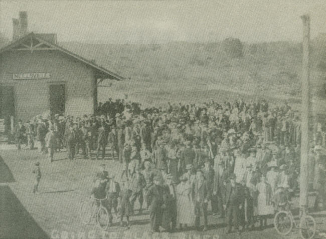 |
A scene at the Neillsville railroad depot after the 1911 flood: Neillsville residents gathered at the depot to board a passenger train for a Sunday afternoon trip to Black River Falls to view the flood’s destruction in that city. They had to transfer trains at Merrillan in order to reach their destination. The return trip also meant transferring which must have made the trip a full day and evening. Today, we are just as curious but travel in our cars to see the floods, etc. (Photo courtesy of Clark County Historical Society).
•••••••••••••••••••••••
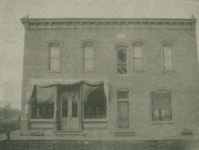 |
The Omaha Hotel, located on 7th & Clay Street corner
(Photo courtesy of Gert DeMert, Neillsville.)
The Omaha Hotel, located on 7th Street and Clay Street corner. The picture was taken during the late 1800s. At that time the hotel’s name had been derived from the Omaha railroad line which ran thru on the tracks a block behind the hotel lot.
There is a sign on the corner of the building which reads, “Neillsville Beer.” The lobby of the hotel had a small bar room area. Fellows who worked at the Neillsville Dairy Products across the street often stopped in at the bar after their day’s work to have a beer and some camaraderie before going home for their suppers.
Sometime during the early 1900s Mr. and Mrs. Paulus bought the business and renamed it the Paulus Hotel. Those words are still faintly visible on the west side of the structure.
The old hotel building has served a purpose for different occupants through the years. At the present time, Bruce Kunze has the ‘Kiln Dried-Cabinetry Shop” in the lower level.
Looking at the picture, the boardwalk runs along the front of the business with the graveled street also in view. Sometime later, brick was laid as a street surface. Only two blocks of bricked street, remains on 7th Street from Hewett to Grand Avenue. It’s a nice reminder of the past and the bricks have withstood much traffic for many years.
Seventh Street is often referred to as “Snake Street” and has been for many years. How did it get that name? If anyone knows, please let us know.
•••••••••••••••••••••••••••••••••
The following paragraphs were written by Ruth Ebert, Neillsville. She shares her memories of dancing at the Riverside Pavilion.
Riverside Pavilion was one of the favorite dance halls of the twenties and early thirties.
It was located in the vicinity of the present Opelt gravel pit (west side of the river) and was built by Frank Luck on the site of his parental home farm. It was operated by Mr. and Mrs. Frank Luck with the help of his sister and brother-in-law Mr. and Mrs. Warren Hoke for most of the years. At various times it was leased to someone else for the season—the last being Al and Thelma Mashin—in the year of 1938. It was at this time that the Lynch Bridge was washed out with the flood of 1938.
The building consisted of the main dance floor and on one end a lunch counter where soft drinks and hamburgers were sold. Meanwhile, outside the building vendors were busy selling their “potent potables,” it being the days of Prohibition – often times fights and brawls appeared along with it.
Ray Kutsche, who later became Clark County Sheriff, was the dance inspector for most of the years it was in operation. Nothing remains of the site, but for a time a small shelter house for the Delco light plant was still visible when driving by. It soon lost its popularity when the Silver Dome came into existence in 1933.
Music was furnished by small orchestras mainly family oriented – usually consisting of 2 – 5 members. The Dux Bros., Wagner’s, Schoengarth, Lautenbach, Klatts, Crandall’s Varsity Boys, Jack Kohlbecks, Vobara, etc, were some of the more familiar.
Tickets were 25¢ - ladies free. A familiar sight, after the dance, the string of cars heading for home, until they came to the bridge where the line parted, those who crossed the bridge going east and those who traveled north on the River road.
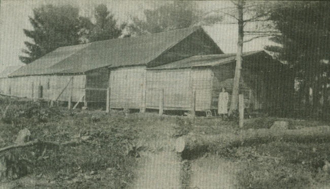 |
Riverside Pavilion was one of the favorite dance halls of the twenties and early thirties.
(Photo courtesy of Clark County Historical Society.)
|
© Every submission is protected by the Digital Millennium Copyright Act of 1998.
Show your appreciation of this freely provided information by not copying it to any other site without our permission.
Become a Clark County History Buff
|
|
A site created and
maintained by the Clark County History Buffs
Webmasters: Leon Konieczny, Tanya Paschke, Janet & Stan Schwarze, James W. Sternitzky,
|