NEGenWeb Project OLLibrary, Journals
NE History & Record of Pioneer
Days
Vol VII, no 3 (part 1)
THE MARCH OF VILLASUR -
1720
- Sunshine shone upon the market in the city Santa Fe,
- Where the traders came to traffic and the padres came to
pray;
- Shone and glinted on the breast plate, on the helmet and
the spur
- Of a valiant Spanish army under Colonel Villasur.
-
- "Go," said Governor Valverde, "Cross the bison-haunted
plains,
- "Bring the Otoe Chief and Pani back to Santa Fe in
chains.
- "Go and plant the Spanish banner by the Jesus San
Maria,
- "Plant the Spanish hacienda from the mountain to the
Sea."
-
- So they crossed the bison plains, marched 300 leagues and
more
- From the hills of Santa Fe, mailed and armed for the
fray,
- With an army of three score valiant Spanish cavaliers;
- With a thousand red allies, eager for the enterprise,
- And a train of muleteers;
- Sheep and cattle with the band, plows and harrows for the
land,
- Spades and mattocks for the mines and for other dark
designs.
-
- And they reached the river shore, River Jesus San
Maria.
- Wonder-eyed the Spaniards saw, full of islands - wide and
free -
- Called by Otoes "Ne-brath-ka," called by Frenchmen "Riviere
Platte,"
- Shining in the summer sun, in a prairie land of plenty
- Anno seventeen hundred twenty,
- From the far off Rocky mountains, fed from snow's eternal
fountains.
-
- Cried the Colonel Villasur, riding to the river's
bank,
- Pricking with his golden spur on his jaded horse's
flank,
- "Spanish I will make this land, from the river where we
stand
- "To the far off Rio Grande,
"From this very August day,
- "Adelante! Nombre de dios; Por El Rey!"
-
- So he camped upon the river, wide and shallow, with his
men;
- Lit their campfires by the river they would never light
again;
- In the grasses and the willows of the river's silver
shallows
- As the night grew gray with morning, stealthily amid the
dawning,
- Crept the river-land's red warriors, crept the Otoe and the
Pani.
- Rushing sudden without warning, Spanish mail and musket
scorning -
- Swift the arrows from their quiver, swifter than the
flowing river
- Fell the Spaniard - fled the ally, in the San Maria
Valley,
- Fell the Spanish flag forever by the far Nebraska
river,
- All the Spanish hope and glory an old-time forgotten story!
-
-Addison E. Sheldon.
SPANISH INVASION OF 1720
Columbus or North Platte - Which Was the
Site of Destruc-
tion of the Spanish Army?
An Assembly of Facts, Authorities,
Arguments, Maps, illustration, Bear-
ing on Important Events in the History of the Platte
Valley
(Prefatory Note)
Berkeley, Calif., July 22nd, 1925
Dear Dr. Sheldon:
I am sending you herewith my article and map on
the Villasur expedition.
I must apologize for the long delay in
forwarding this material to you. My teaching duties here proved
heavier than I anticipated. The preparation of the article too,
developed some problems, the magnitude of which I had not realized
until I examined the Villasur material in relation to other
sources bearing on similar expeditions. I found, as I believe will
be seen from the paper, that a brief presentation of the latter
was necessary to a consideration of the Villasur sources.
I am leaving for Europe about August 6th or 7th
to work in the Archives of Seville and Paris for *the coming year.
I plan to examine early eighteenth century material bearing on the
western Mississippi Valley area. There is every reason to believe
that the Archives have valuable information on that interesting
frontier, especially with regard to the Platte River. I regret my
route east will not take me through Lincoln.
It has been a genuine pleasure to prepare this
article and I sincerely appreciate your kindness in extending me
the opportunity to present it in the pages of your Society's
publication.
Sincerely,
A. B. THOMAS.
P. S. - When you
write, will you please tell me what arrangements I can make for reprints? Thank
you.
A. B. Thomas
2112 Durant Ave.,
Berkeley, California.
THE MASSACRE OF THE VILLASUR EXPEDITION
AT
THE FORKS OF THE PLATTE RIVER
AUGUST 12, 1720 *
By A. B. THOMAS, University of California, Berkeley
In August of the summer of 1720, a band of
Spaniards and Indian allies under the command of Pedro de
Villasur, while searching for French intruders, were massacred
almost to a man along the Platte River. This attack, which came
with such suddenness on that quiet August morning, is one of the
many stirring episodes which marked the Franco-Spanish border
conflict in the heart of the continent in the early eighteenth
century. The antecedents of the incident are found in the French
occupation of the Mississippi Valley in the last years of the
seventeenth and the early years of the eighteenth century. These
activities of the French caused the Spanish authorities of Mexico
to take steps to limit the French settlements to as small an area
as possible. Between 1686 and 1689 the Spaniards sent expeditions
into Texas under Alonzo de León to locate and expel the
French led by LaSalle. Then followed, first the temporary, and
later the permanent occupation of eastern Texas by the
establishment of a presidio and missions between the Neches and
the Red Rivers. Spain's easternmost outpost then was Los Adaes,
founded in 1717.1
By this time the rumored and the actual advance
of the French up the Missouri and the Platte, towards New Mexico,
set in motion a similar process of Spanish expansion on that
northern frontier. The expedition of Villasur and the proposal, at
the same time, to establish a presidio and a mission at El
Cuartelejo in eastern Colorado, are similar in all their purposes
and supplementary to the expeditions of De León and the
settlement at Los Adaes. The Texan establishments were designed to
check the French advance by way of the Red River and the Caddo
tribes; the Colorado (Cuartelejo) project was an attempt to
protect another Spanish frontier, New Mexico. against the French
advance up the Missouri and the Platte. The process in Colorado
differs from that in Texas only in results, for the Cuartelejo
plan was nipped in the bud by the massacre on the Platte River.
*This article has been written very largely from
materials in Professor H. E. Bolton's Collection. For the liberal
use of these materials, for his generous advice and criticism at
every stage, the writer takes pleasure in acknowledging the heavy
debt of gratitude he owes to Professor Bolton.
1Bolton, H. E., and Marshall, T. M.,
The Colonization of North America, 249-250.
Origin of the Villasur
Expedition
For the authorities in Mexico the
establishments in Texas were a source of information regarding the
movements of the French in their expansion westward. About two
years after the founding of the mission of Los Adaes, a frontier
captain in Texas reported to the viceroy in Mexico City that a
number of Frenchmen were marching to attack the mines of Santa
Fe.2 The viceroy thereupon despatched a letter to
Antonio de Valverde, the Governor of New Mexico, ordering a
reconnaissance.3 The governor accordingly held a junta
de guerra on the 2nd of June, 1719, to discuss the expedition, but
decided, however, to postpone the investigation until the
following spring.4 The situation now suddenly took on a
serious aspect. In July the viceroy received news from Spain that
war had broken out with France in January. The government in New
Spain was ordered to place the frontiers in shape to prevent a
possible invasion.5
The actual approach of the French seemed to be
confirmed by an expedition which the governor of New Mexico made
in the fall of the same year, between September and November. On
this expedition Valverde penetrated as far as the Arkansas River
in pursuit of some Utes and Comanches who had been ravaging the
New Mexico frontiers. While the expedition was encamped on the
Arkansas, in the neighborhood of the present day Las Animas, the
whole Indian Settlement of El Cuartelejo came down to visit the
commander. During the visit the governor's attention was drawn to
a bullet wound carried by one of these Indians. On questioning
him, Valverde learned that a party of Jumanos, Pawnees, and
Frenchmen had attacked this Indian and others of his tribe, on
their own land far beyond El Cuartelejo, apparently near the South
Platte River.6 This new evidence of the French advance
caused uneasiness.
On his return to Santa Fe Valverde sent a
courier to Mexico carrying an account of his
expedition.7 This courier seems to have arrived in
Mexico City about the same time that a messenger arrived there
from the Governor of Parral, a northern province of Mexico. This
latter courier brought
2 Autos de echas pr. el Brigadier Dn
Pedro de Rivera en razon de la pesquisa contra dn Antto de
Valverde, in Provincias Internas, tomo 37, expediente no. 1, f 13,
archivo general de Mexico. (Ms Bolton Collection.)
3 Twitchell, R. E., Spanish Archives
of New Mexico, II, p. 189, no. 308.
4 Testimony of Valverde in Provincias
Internas, tomo 37, expediente no. 1, f. 13. (Ms. Bolton
Collection).
5 Duran to the Viceroy, January 30,
1719. Historia, tomo 394, no. 4. Archivo General de México.
(Ms. Bolton Collection).
the startling and exaggerated news that some six thousand
invading Frenchmen were seventy leagues or about one hundred and
seventy-five miles from Santa Fe. 8
On the 28th of December the fiscal of the
Audiencia, who received from the viceroy the documents from Parral
and New Mexico, turned them over to the Auditor General de Guerra.
The fiscal pointed out that Valverde's report indicated that the
French were not an immediate menace but that any advance on their
part ought to be prevented. Accordingly, the Auditor, who accepted
the suggestions, recommended to the council that, among other
things, the Governor of New Mexico should establish at El
Cuartelejo a presidio garrisoned with twenty or twenty-five men
and accompanied by two missionary fathers, and at the same time
strengthen the Spanish alliance with the Apaches in that
region.9 At a council of war held in Mexico City on the
13th of January, 1720, the viceroy approved the Auditor's
suggestions regarding the presidio at El Cuartelejo and again
ordered the Governor of New Mexico to conduct a reconnaissance of
the French position on that frontier, to secure details about
their mode of living, numbers, and location,10 on the
Rio Jesus Maria, where their establishments were reported to
be.11
From Santa Fe to El Cuartelejo
In June, 1720, Governor Valverde assembled a
force in Santa Fe and placed it under the command of his
Lieutenant-General, Don Pedro de Villasur. It is not clear just
why Valverde himself did not lead the expedition, but it is known
6 Diario y derrotero que cujio el Sr.
General Dr. Antonio Balverde Cosio, Governor General de este Reyno
y Governor provincias de la neuva Mexico en la campana que
ejecuto, las Naciones Yutas y Commanchos, 1719. (Ms. Bolton
Collection).
7 Dunn, W. E. Spanish Reaction
Against the French Advance Toward New Mexico, in Mississippi
Valley Historical Review, December, 1915, pp. 349-359. This
article is an excellent and reliable interpretation of the Spanish
sources bearing on Villasur's expedition, excepting the fragment
of Villasur's diary which of course was not known to exist
then.
8 Manuel de San Juan de Santa Cruz to
the Viceroy, December 11, 1719, Historia, Tomo 349, no. 11 Archivo
General de México. (Ms. Bolton Collection.) A Spanish league
is about 2.5 or 2.6 miles.
9 Fiscal al Senor Auditor de ]a
Guerra, Mexico City, December 28, 1719, Historia, tomo 394, nos.
12 and 13, Archivo General de México. (Ms Bolton
Collection.)
10 Viceroy to Valverde, January 13th,
1720, Historia, tomo 394, no. 19 Archivo General de
México. (Ms Bolton Collection.)
11 Valverde to the Viceroy, November
30, 1719, Historia, tomo 394, no. 7, Archivo General de
México. (Ms Bolton Collection.)
that on account of its tragic outcome he was later removed from
office and brought to trial.12
The story of Villasur's march to the Platte
opens on the 15th of June, 1720. On that day Valverde despatched
to the viceroy a final statement bearing on the advisability of a
presidio at La Jicarilla, a point somewhat closer to Santa Fe than
El Cuartelejo, saying that Villasur was departing the next day to
reconnoitre the French in the northeast.13 On the
morning of the 16th, the expedition, well supplied for their long
journey, set out from Santa Fe.
With Villasur were forty soldiers, some settlers
or traders who had probably volunteered for trade or adventure,
and seventy Indians. Villasur himself had been in New Mexico a
number of years and had acted as Valverde's Lieutenant-Governor in
1719. However, there is some question as to his fitness for Indian
scouting. With Villasur went an interesting Frenchman, Jean de
l'Archeveque, who had been a member of Juan de Uribarri's
expedition to El Cuartelejo in 1706, and who, almost twenty years
still earlier, had had a hand in the assassination of La Salle. He
had become a trader. Besides being the official interpreter, he
took on the journey ten horses and six mules loaded with
commodities to trade with the Indians. He probably assumed that
his part in the murder of La Salle was of little risk to him.
Chaplain Fray Juan Minguez was the ever-present priest. Joseph
Naranjo led the Indian allies. In addition, there were others who
were veterans of both Valverde's and Uribarri's expeditions into
the Cuartelejo country.14
From Santa Fe the expedition traveled northeast
to El Cuartelejo. The route to this spot was one very well known
to the Spaniards, who had traveled it back and forth for almost
three-quarters of a century, at least, before 1720. Briefly this
route was north from Santa Fe to Taos. From Taos the expeditions
proceeded east over the Culebra15 Range and then, at
the foot of the eastern slopes, turned north to pass through
12 Autos echas pr. el Brigadier Dn.
Pedro de Rivera in Provincias Internas, Tomo 37, expediente no. 1,
(Ms Bolton Collection.)
13 Valverde to the Viceroy, June 15,
1720, Historia, tomo 394, no. 28. (Ms Bolton Collection.)
14 Valverde to the Viceroy, October
8, 1720, Historia, tomo 394, nos. 29-35; The list of Spaniards and
Indians killed as given by Captain D. Felix Martinez is 34
Spaniards and 11 Indians: Martinez to the Viceroy, Historia, tomo
394, no. 55 (Ms Bolton Collection.)
15 U. S. Land Map, 1918, Dept. of the
Interior designates this range as the Culebra Range. The range as
a whole is the Sangre de Christo. Possibly a more accurate
designation would be the Taos Range.
the La Jicarilla Indian country of northeastern New Mexico, a
movement which brought them to the headwaters of the Purgatoire
River. From this river they proceeded north again through the
Carlana Indian country, closely hugging the foothills of the
Rockies until they came to the Arkansas or, as the Spaniards and
Indians called it, the Rio Napestle. The expeditions arrived on
the Napestle about in the neighborhood of present day Pueblo,
crossed there and continued eastward to El Cuartelejo.
We are fortunate in the possession of the
diaries of the commanders of at least two prominent expeditions
which establish details, with regard to both geography and
distance, of this well known route. Of the two, the earlier
expedition is that of Juan de Uribarri, who went to El Cuartelejo
in 1706.16 His line of march after leaving Taos was
east eighteen leagues over the Culebra Range. This journey brought
him to the junction of the Cimarron and Rayado Creeks. At this
point he changed his route to due north for eighty leagues. The
movement took him through the Jicarilla country, over the divide
separating the headwaters of the Red and the Purgatoire Rivers,
across the Purgatoire, and through the Carlana country to the
banks of the Rio Napestle. Their arrival on the stream was
probably at a point a little west of Pueblo of today. They had now
traveled one hundred and twenty leagues from Santa Fe. Crossing
the river here they journeyed in a general eastern direction to El
Cuartelejo, where they pitched their camp in the knee of two small
streams. The recorded distance of this journey eastward was but
twenty-two leagues; but there is ground for assuming that their
total distance was close to thirty leagues, or about eighty
miles.
Thirteen years later, as noted above, the
Governor of New Mexico set out from Santa Fe to punish some
marauding Comanches and Utes. This expedition, which left on
September 15, 1719, followed about the same route as that of
Uribarri, and as a consequence Valverde mentions many of the
prominent features noted by Uribarri, such as the Culebra Range,
the Jicarilla Indians, the range between the Red and the
Purgatoire, a stream evidently the Purgatoire, the Carlana
Indians, and the Arkansas River. In a similar manner, the
expedition found itself after a march of one hundred and nine
16 Diario y derrotero que hizo el
Sarg. lo mayor Juan de Ulibarri de la journada que executo de
orden del Sor Governor y Capitan General de este Rno Don Franzco
Cuerbo y Valdes, in Provincias Internas, tomo 36, numo. 4, Archivo
General de México. (Ms Bolton Collection.)
leagues from Santa Fe just south of the present Pueblo. Here
Valverde swerved to the northeast and continued down the south
side of the Arkansas for forty leagues, halting near Las Animas of
the present day. At this point Valverde was visited by the whole
settlement of El Cuartelejo Indians, who came down to pay their
respects to him. The Indians had consumed four days' time in
reaching the Arkansas. Since they were a thousand strong, men,
women and children it took them this length of time to cover the
distance which separated Valverde from the spot where Uribarri had
come upon El Cuartelejo. Such a throng must have traveled very
slowly, and the distance could not have been great.
This in brief was the general route followed by
the Spaniards of New Mexico to the Colorado plains. With this in
mind let us turn to a consideration of the material bearing on
Villasur's route. We find almost immediately many things which
establish that he too followed the usual route. The diaries,
mentioned above, of Uribarri and Valverde not only do valuable
service in giving us interesting details of the country through
which the Spaniards passed on the way to El Cuartelejo, but in
addition, they furnish strong reasons why Villasur went that way.
Obviously, the first reason which suggests itself is that the
route was the customary one. In the second place, we know from the
sources for the three expeditions that Villasur had with him
several of the same men who, like Naranjo and l'Archeveque, had
accompanied both Uribarri and Valverde. Naranjo, especially, had
acted as guide and scout for both Valverde and Uribarri, and we
find him in this capacity under Villasur.17 But we are
not wholly dependent on inference for several of the documents
state that the Villasur expedition went northeast.18
that it passed through the Jicarilla and Carlana
country,19 and finally, that, in the land of the
Carlanas, it crossed the Rio Napestle on "balsas"
(rafts).20 Thus it seems clear that Villasur's route
was the usual one to El Cuartelejo.
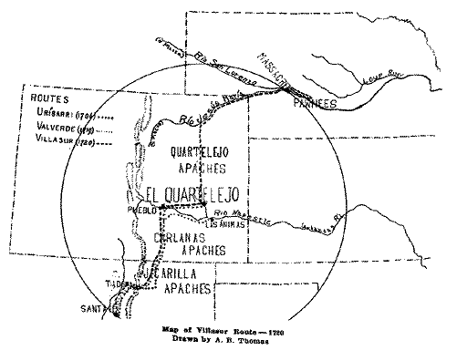
The Location of El Cuartelejo
El Cuartelejo, is a spot which challenges
interest. Not only was it, with Virginia, one of the points
farthest north
17 See below page 13 where Villasur
states that Naranjo is ahead looking for the Pawnees.
18 Testimony of Aguilar, Provincias
internas, Tomo 37, expediente no. 1, f. 16. (Ms Bolton
Collection.)
19 Bandelier, A. F., Expedition of
Pedro de Villasur in the year 1720, citing Auto of Felipe Tamariz
in Autos sobre Commercio illicito con los Frances del Oriente y de
la Louisiana. Papers of the Archaelogical Institute of America,
Series V, p. 191, note 2.
20 Ibid., p. 197, note 1. Bandelier
cites both Aguilar and Tamariz.
to which Spanish influence penetrated before 1763, but its
location for many years has been a subject of dispute and error.
And inasmuch as the proper location of the spot a decisive factor
in determining the site of the battle on the Platte, it must be
considered here. Since 1900 the location accorded El Cuartelejo
has been in Scott County, Kansas, largely because of the
unearthing there of an old adobe ruin which was forthwith claimed
to be the outpost known to the Spaniards as El
Cuartelejo.21 To this location the weight of the
opinion of F. W. Hodge and other distingished scholars has been
given.22 However, the writer's attention was first
directed by Professor Bolton to the fact that location was too far
east and that this outpost was the present bounds of Colorado. The
short summary given below of the essential details of Uribarri's
and Valverde's diaries and other supplementary material bearing on
El Cuartelejo entirely confirms Dr. Bolton's opinion that El
Cuartelejo was in eastern Colorado.
The diaries in this connection have a double
value. They have enabled us to determine the route from Santa Fe
to Cuartelejo. In the second place, owing to the carefully kept
record of distance traveled each day, we are able to work out with
a fair degree of accuracy how far El CuarteleJo was from Santa
Fe.
In the case of Uribarri we noted his route was
east eighteen leagues from Taos to the eastern foot of the Culebra
Range. He followed these foothills of the Rockies north eighty
leagues until he arrived on the Arkansas, a distance from Santa Fe
of one hundred and twenty leagues. Crossing the Arkansas at about
the present site of Pueblo, he continued east a recorded distance
of twenty-two leagues. He gave no distance on two of the seven
days consumed on this march. But on one of them he was lost; on
the other he simply states that the expedition traveled "a short
distance" and arrived at El Cuartelejo. One hundred and fifty
leagues probably represents his total distance from Santa Fe to
that point.
With regard to Valverde, he, too, traveled north
along the foothills after crossing the range east of Taos. This
northern march, also eighty leagues, found the expedition encamped
a short distance south of present Pueblo. At this point Valverde
swerved to the east and for forty leagues and marched down the
south side of the Rio Napestle. His total recorded
21 Williston, S. W., and Martin, H.
T., Some Pueblo Ruins in Scott County, Kansas. Kansas Historical
Collections, Vol. 8, 1897-19 pp. 126-127.
22 Hodge, F. W., Handbook, part 2, p.
337, article Quartelejo.
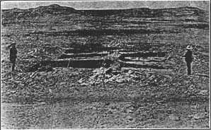
Ruins of Old Pueblo Building in Scott County, Kansas,
claimed
to be El Cuartelejo.
From Kansas Historical Society Collections, Vol. X1 (1009-10). p.
409
distance was at the point at which he halted, near present Las
Animas, one hundred and forty-nine leagues. And, it will be
recalled, it was at this point that he awaited the arrival of the
large body of Indians who came from El Cuartelejo to the opposite
bank of the Arkansas. These Indians, men, women, and children,
could have traveled but a short distance in the four days they
consumed between El Cuartelejo and the Arkansas. This distance at
the most was probably not more than thirty or thirty-five miles.
If this distance is measured north from Valverde's position on the
Arkansas, a point will be reached about where Uribarri came upon
El Cuartelejo.
To recapitulate: Uribarri's total recorded
distance was one hundred and forty-two leagues; Valverde's one
hundred and forty-nine. In addition there is also an official
report written in 1727 which states that El Cuartelejo was one
hundred and sixty leagues from Santa Fe.23 As has
been suggested Uribarri probably traveled close to one hundred and
fifty leagues. Both expeditions turned east about in the vicinity
of present Pueblo. Uribarri, giving him the full benefit of the
doubt, probably traveled thirty leagues east to El Cuartelejo.
Valverde we have seen traveled forty leagues. In either case these
distances represent but one-third of the
23 Bustamente to the Viceroy, April
30, 1727, Provincias Internas, tomo 37, expediente no. 1, f. 74.
(Bolton Collection.)
total recorded distance to Pueblo, and if that short distance,
is measured off eastward from Pueblo a point will be reached which
is but about half way to the eastern boundary of Colorado.
El Cuartelejo in Kiowa County, Colorado
To summarize, if
one hundred and forty or one hundred and fifty leagues are measured off from
Santa Fe along the route of Uribarri, El Cuartelejo will be found to be in
western Kiowa county. And inasmuch as Uribarri spoke of a number of
streams about the spot, and camped in the junction of two, the
writer believes the location to be at the union of Mustang and
Adobe Creeks.
From El Cuartelejo to the Platte River
When the expedition
left El Cuartelejo to look for the French, it proceeded directly to the South
Platte. This fact is established by a number of sources. The South Platte
was well known to the Spaniards as the Rio Jesus
Maria.24 Documents state it to be fifty to seventy
leagues from El Cuartelejo.25 We know that on August
6th the expedition was on the Jesus Maria after a northeastward
march of three hundred leagues from Santa Fe.26 Soon
after, on the 8th, the commander mentions the junction of the Rio
Jesus Maria with another stream which he called the Rio San
Lorenzo.27 That junction must have been the forks of
the Platte. An air line drawn northeast from Santa Fe to
the forks of the North and South Platte cuts almost directly
through El Cuartelejo, which is just about one-half way on such a
line. This fits the sources, for El Cuartelejo was, as we have
seen, about one hundred and fifty leagues from Santa, Fe, while
the junction was three hundred.
The possibility of another junction must be
considered. The Loup, which forms a junction with the Rio Jesus
Maria
24 Valverde to the Viceroy, October
8, 1720, Historia, tomo 394, no. 29, Archivo General de
México. (Ms Bolton Collection.)
25 Auto of Captain Felix Martinez
gives fifty leagues: Historia tomo 394, November 13, 1720, no. 38;
Naranjo says seventy: See Bandelier, Expedition of Villasur, page
185, note 2.
26 "Testimony of Aguilar, Provincias
Internas, Tomo 37, Expediente no. 1, f. 6. (Ms Bolton
Collection.)
27 Sheldon, A. E. A New Chapter in
Nebraska History, "Translation of a leaf from a journal in
Spanish, found at the defeat of a detachment of that nation by the
Otoptata." Nebraska History and Record of Pioneer Days, Vol. Vi. no. 1,
January-March, 1923, pp.
13-19.
or rather the Platte, was adopted by Baron Marc de
Villiers.28 But that junction lacks the support of
distance. El Cuartelejo was half way from Santa Fe to the
junction, but from Santa Fe to the mouth of the Loup, the outpost
would be only one-third of the way. It seems evident to the
writer, therefore, that the command proceeded directly to the
South Platte, Jesus Maria, and continued east along that stream
searching for the reported French establishments, until the 6th of
August, on which date they were within a short distance of the
junction, after having traveled a total distance of three hundred
leagues.
The Spaniards at the Forks of the Platte
We may now proceed
with our story. The march from El Cuartelejo to the Jesus Maria had been fruitless;
no sign of the French had been found. So Villasur, considering the great
distance he had traveled, came to a halt on the 6th of August and
decided to hold a junta de guerra to consider whether or not they
should continue into the land of the Pawnee, on whose borders they
now were. The decision was to cross the Jesus Maria and go on.
Villasur himself can best state his movements at this time. ". . .
Since one day did not suffice to transport everything our camp was
divided that night by the river . . . Wednesday 7: At the break of
day we crossed over the remainder of our baggage and people to the
other side of the river of Jesus Maria. This was not without much
trouble, but at last we found ourselves together at noon. Thursday
8: We leave the river Jesus Maria, following the trail of the
Panane . . . We found, at a league from the river (Rio Jesus Maria)
a large creek which it was necessary to cross and we thought from
the water, which was very warm, that it was a branch of the river
whose course was from west to east. We then marched over a plain,
following always the trail of those who had gone before us. We saw
a number of trees a league away and we met one of our savages who
was of Captain Narran's (Naranjo) detachment and who had orders to
wait for us to tell us to follow the creek and that he would
follow the trail of those (the Pawnees) since they found no one in
the villages. The camp arrived at the bank of the creek, and, as
it was impossible to cross with our arms, we were obliged to keep
along its bank and follow the same route as that taken by Captain
Narrans. We had already traveled three
28 Villiers, Le Baron Marc de, Le
Massacre de l'expedition espagnole du Missouri (11 aout 1720).
In Journal de la Société des Americanistes de Paris,
Nouvelle Serie, Tome XIII, 1921, p. 249.
leagues to reach the creek; we marched
three more to arrive at a plain." The meaning of this passage seems to be that
after crossing the Rio Jesus Maria they came to the North Platte, or the
San Lorenzo, but that they did not cross it on the eighth but
continued to march along its bank for three leagues. On the next
day, the 9th, they crossed the stream: more "Friday 9. The camp
being ready to march we saw, at than a league's distance, someone
approaching at a gallop. . . . We found that it was one of our people. . .
. He told us that eight leagues distance, on the other side of the
creek we were following, they had found the Panane in a bottom . .
. Upon this news the order was at once given to cross to the other
side of the stream. It was carried out with so much good fortune
that everything went over without getting wet, although the mules
were up to their girths in the water. We marched three leagues
along the creek and found it convenient to halt at five leagues
distant from the tribe, according to the report of those who
brought in the news."29 Their camp was right at the
junction of the two streams:". . . The general named the creek Saint
Laurent (San Lorenzo). The river Jesus Maria unites with this
creek where we are; so large is the stream there that if we had
not crossed before, it would be impossible to do so."30 Without doubt the Saint Laurent, or Sari Lorenzo,
was the North Platte.
As soon as Villasur had come to a halt he sent
his Pawnee interpreter to his kinsmen to assure them of the Spaniards'
friendship and good will. The interpreter left about
eleven o'clock in the morning and came flying back at six in the
evening to report that the Indians he found had threatened him
with hatchets. Their villages he said were or the other side, that
is south, of the river.
The Meeting with the Pawnee
The Spaniards on the following morning
marched toward this village and came to a halt opposite the
Pawnees. They signalled the Indians, who answered them. According
to the Spaniards' interpreter, the Pawnees said that they did not
wish to join the Spaniards but that they wanted their interpreter
to cross and talk with them. The interpreter surprised the
Spaniards by his willingness to go in spite of his fear of the day
before. Before he left, Villasur instructed him and gave him
presents to distribute among the chiefs.
29 Sheldon, A. E., A New Chapter in
Nebraska History, p. 17.
30 Ibid., p. 17.
This incident occurred on the 10th of August, and here the
fragment of the diary ends.31
Other Spanish documents, however, take up the
story at this point. According to the testimony of a survivor,
Idelfonso Rael de Aguilar, Villasur gave the Pawnee interpreter
knives and bundles of tobacco. The interpreter did not return, but
another Pawnee came over whom the Spanairds were unable to
understand. The Spaniards asked their own interpreter, who
appeared the next day on the bank opposite, why he did not return
and if there were among them any other "Spaniards" (French, of
course, for the Indians called all who were white, "Spaniards").
He replied that he did not know of other "Spaniards" and that the
Pawnees would not let him return. To consider the matter, Villasur
called a council of war. He and others wished to cross the river
and get the information that was not forthcoming. A majority of
the council, however, opposed the move on the ground that it was
dangerous and that the Pawnees had already given proof of their
bad faith by holding the interpreter.32
Another account gives a different version of the
interview. This is Valverde's report of the defeat which he sent
to the viceroy. Valverde apparently based his information on the
tales of the survivors.33 Some Pawnees, he wrote, came
across the river to visit the Spaniards. These said that among
them were some "Spaniards." On hearing that the Lieutenant General
immediately ordered l'Archeveque to write a letter in French.
Their Pawnee interpreter carried this to his kinsmen across the
river and returned shortly with a reply and accompanied by another
Indian who carried into the Spanish camp a French (Breton) flag.
The reply was written on some old paper and was wholly
unintelligible to either l'Archeveque or the Spaniards. The
commander thinking that the French were handicapped by the lack of
writing materials, sent back paper, ink and a quill. At the same
time he sent another letter in Spanish.
The Retreat to the North Platte
For two days the Spaniards awaited
a reply,34 but
none was forthcoming. The delay filled them with apprehension and
fearing treachery of some sort, they decided to retreat
31 Sheldon, A. E., A New Chapter in
Nebraska History, pp. 17-19.
32 Testimony of Aguilar, Provincias
Internas, Tomo 37, expediente no. 1, f. 6. (Ms. Bolton
Collection.)
33 Valverde to the Viceroy, October
8, 1720, Historia, tomo 394, nos 29-35; Testimony of Valverde,
Provincias Internas, tomo 37, expediente no. 1, f, 4. (Ms Bolton
Collection.)
34 Testimony of Aguilar, Provincias
Internas, tomo 37, expediente no. 1, f. 6. (Ms Bolton
Collection.)
on the 11th. Returning the same distance35 to the
San Lorenzo they recrossed, doubtless at the same ford they had
found two days before.36 On the south bank of this
stream, the North Platte, they cleared a space in the tall grass
and pitched camp about four o'clock in the afternoon. When night
came Villasur. charged his sentinels with caution, though he felt
safe after their long retreat. The night was spent in perfect
quiet except that shortly after nightfall the slumber of the camp
was disturbed by the loud barking of a dog. The dog was aroused
apparently by a band of Pawnees moving cautiously along the banks
of the river near the camp. The commander did nothing more,
however, than to caution his guards to redouble their
vigilance.
The Massacre on the North Platte
The break of dawn
found the Spaniards astir making ready to continue their move southward. Suddenly
in the confusion of breaking camp the party was swept by a murderous fire
of shot and arrows. The stampeding horses threw the camp into
further panic and before Villasur could organize a defense he was
slain. The priest was shot down where he stood, and l'Archeveque
went to join La Salle. Those who could flee did so, but when the
smoke cleared forty-five Spaniards and Indians lay dead in the
grass.
The arrival of the survivors in New Mexico threw
the whole province into alarm. Valverde shared in the general fear
and urged upon the viceroy the necessity of a garrison at La
Jicarilla. However, talk, investigation and attempts to locate the
site of the massacre followed with no move to take the protecting
step. But all danger from further French aggression was removed by
a treaty signed by France and Spain on March 27th, 1721. Until the
acquisition of the Louisiana territory in 1763, this expedition
marks the high tide of Spanish expansion northeast of Santa
Fe,
North Platte, the Location of the Villasur
Massacre
The exact location of the massacre of the
Villasur command can now be determined with a considerable degree
of accuracy. We have seen that on the 6th of August the Spaniards
had traveled three hundred leagues and were somewhat west of the
Rio Jesus Maria or the South Platte. They spent the 6th and until
noon of the 7th in crossing this stream. On the 8th they left the
stream and came to the San Lorenzo,
35 Testimony of Valverde, Provincias
Internas, tomo 37, expediente no. 1, f, 4. (Ms Bolton
Collection)
36 Ibid., f, 4 also Testimony of
Aguilar, Provincias Internas, tomo 37, expediente no. 1, f, 6. (Ms
Bolton Collection.)
a league's distance away, or possibly three leagues, and had
continued along it three leagues into a plain. On the 9th they
received news that the Pawnees were eight leagues ahead on the
other side of the stream. Villasur crossed, marched three leagues
and went into camp at the junction. On the 10th they marched five
leagues until they were opposite the Pawnees, communicated with
them, became suspicious and retreated eight leagues on the 11th.
Aguilar tells us that they recrossed the San Lorenzo, or the North
Platte, at four o'clock in the afternoon and made camp. On the
following morning, the 12th, the massacre occurred.
Inasmuch as they retreated over the ground they
had come two days before, it is highly probable that they
recrossed the San Lorenzo where they had found a ford the first
time. Since we know this crossing was three leagues, about seven
miles, from the junction, the massacre occurred either just west
of, or on the present site of the town of North Platte.
In conclusion a few general comments suggest
themselves. It is patent that the determination of the site of the
massacre depends wholly upon the location of El Cuartelejo, since
it is known that the expedition passed through that spot and that
it reached the Rio Jesus Maria. If the Kansas location were to be
accepted then a northeast march from the spot might bring the
expedition to a point on the Platte River near its junction with
the Loup. As mentioned above, Baron Marc de Villiers, who
discovered the fragment of Villasur's diary in the Archives of
Paris and whose interpretation of it has been very ably
translated, edited and published in a recent number of this
magazine by Professor A. E. Sheldon, adopted the junction with the
Loup as the site. But there are two facts which make impossible
such a site. In the first place, the detailed records of the
relations which the Spaniards had with El Cuartelejo all indicate
that the spot was well within the present state of Colorado, and
that it was, as the Spaniards traveled, approximately one hundred
and fifty leagues from Santa Fe. The forks of the Platte we have
seen were three hundred leagues from Santa Fe. With this in mind,
if an arc whose center is at El Cuartelejo is circumscribed to cut
through Santa Fe, it will also cuts through the Junction of the
North and South Platte but will only reach about half way to the
Loup and the Platte. It follows, therefore, that the Loup is a
third too far from Santa Fe and almost twice too far from El
Cuartelejo to agree with the sources outlined above.
Vol VII, no 2 


 Vol
VII, no 3, part 2
Vol
VII, no 3, part 2
Return to NE History & Record
of Pioneer Days
© 2001 for NEGenWeb Project by Ted &
Carole Miller
© NeGenWeb