|
|
82 |
|
|
83 |
It is a pleasure
to have the opportunity to discuss the enlightening and well presented article
by Professor A. B. Thomas on the location of the Villasur Massacre of 1720.
Such discussions throw new light on the subject, help to correct
mistakes, and enable us to arrive more closely to the truth. While
the Professor's hypothesis appears plausible, yet I cannot agree
with his conclusions. His argument is based on a supposed location
of El Cuartelejo in Colorado, and on his interpretation of the
leaf from a Spanish Officer's diary or journal of the
expedition
Our knowledge of El Cuartelejo is meagre and
fragmentary as follows: In 1778, the Franciscan, Father Escalante,
wrote; "About the middle of the last century (1650) some families
of Christian Indians of the town and nation of the Taos revolted,
and retired to the plains of Cibola, fortifying themselves at a
place, which on this account was called El Cuartelejo (The Far Off
Post), where they remained until Juan de Archuleta marched
thither, by order of the Governor, with twenty soldiers and some
Indian auxiliaries and obliged them to return to their pueblo. He
found in their possession kettles and other articles of copper and
tin. and asking them whence these had been obtained, they said
from the Quivira (Pawnee) towns, to which they had made a journey
from Cuartelejo. This statement caused universal astonishment and
satisfaction to the Spaniards and Religious in the kingdom, as
they supposed these kettles and other utensils to have been made
in Quivira, which they believed must be a very civilized and
wealthy kingdom. From El Cuartelejo, by that route is the way to
the Panana (Pawnee) and it is evident at this day (1778) that
there are no other towns in that direction, and the French already
trafficked with them (Pawnees) at that time."1
The above trading events must have taken place
after the year 1659, as the first record of French traders in the
vicinity of Nebraska or Quivira (Skidi-ra, or Wolf people) was the
visit of the Frenchmen Radisson, and Grosseilliers in that year,
to the "Forked River" (Missouri and Platte Rivers) that divides
itself in two with a branch towards the west and the other towards
the south which they believed ran towards Mexico from the tokens
given them.2
However, the place of this visit is still a
matter of controversy. In 1704, some Picuries Indians fled from New Mexico
to Cuartelejo, where they remained two years until Captain
Uribarri marched there (in 1706) and took possession, naming the
province San Luis, and the Indian rancheria Santo
Domingo.3
1 U. S. Catholic Hist. Mag. vol. III,
p. 86-87.
2 Wisconsin Hist. Colns. vol. XI, p.
70.
So.
Dakota Hist. Colns. vol. 1, p. 173.
3 Bancroft, H. H., Ariz. & New
Mex. vol. XVII, p. 229.
|
84 |
|
Twitchell says, that after the
reconquest of New Mexico some of the Picuries joined the Jicarilla Apaches
at this post, and that since that period, both tribes have intermarried.4
July, 1715, the Duke of Linares, Mexico, sent an
order of the Viceroy for Captain Naranjo, to carry a letter to
Cuartelejo.5
In 1719 Valverde was visited by the Cuartelejo
Apaches somewhere on the Arkansas River6, and in 1629
Villasur's Expedition called there on their way to the Rio
Jesus-Maria, or Platte River.7
In 1727, Gov. Bustamente notified the Viceroy
that the French had settled at Cuartelejo, and proposed an
expedition to find out what being done, and asking for troops for
that purpose. His request was not granted, but he was to obtain
all possible information about from the Indians.8
This last report was probably caused by rumors
about Bourgmont's expedition to the Padoucas or Comanche in Kansas
in 1724, or about the establishment of the military and trading
post of Fort Kansa, on the Missouri River, in the vicinity of the
present Ft. Leavenworth, in 1726 or 1727.9
The above is substantially all that we know, so
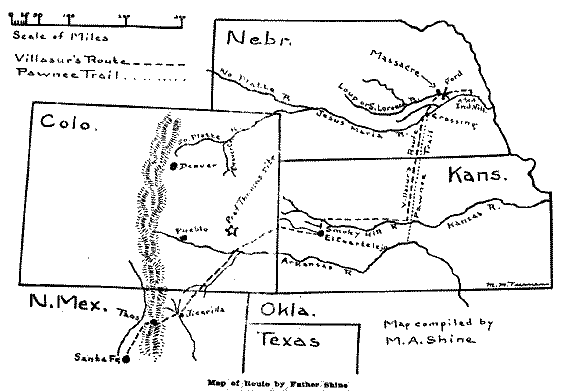
far, about El Cuartelejo. Now, was it located in Colorado or in
Kansas?
It would be interesting to us to read the two
diaries of Uribarri and Valverde, and trace out their route for
ourselves. Since their destination was El Cuartelejo on the
eastern plains, we cannot understand their hugging the foothills
of the mountains for eighty leagues to the north.
The Colorado location is only a supposition of
where it ought to be, to fit a hypothesis, and is not confirmed or
strengthened by a solitary fact. On the other hand the airline
proposition is a rather unfortunate one for this hypothesis.
The airline distance from Santa Fe to the
junction of the North and South Platte Rivers, on Mooney's "Map of
the Kiowa Range"10, is about 470 miles, or not quite
180 Spanish leagues.
If the Colorado Cuartelejo, is half way, then it
only 235 miles. or less than 90 leagues from Santa Fe, and
consequently, it does not, "fit the sources" and amazingly "lacks
the support of distance.11
Again the airline distance from the Cimarron
junction, or Jicarilla, to Pueblo, Col., is only 110 miles or 49
leagues, whereas 80 leagues north from the same junction, or 210
miles, would bring the expedition within 15 miles of Denver, Col.,
and Cuartelejo being "30 leagues or 80 miles eastward, would be,
by coincidence, located on a branch of Beaver Creek in Colorado, a
tributary of the South Platte River.
This location would bring Cuartelejo within 175
miles, or 66 leagues of the junction of the North and South Platte
Rivers, which location of course, Prof. Thomas could not grant,
because it is about two thirds,. instead of one half the distance
from Santa Fe.
4 Twitchel, R. E., Spanish Archives
of N. Mex. vol. II, p. 236, no. 542.
5 Twitchel, R. E., Spanish Archives
of N. Mex. vol. II, p. 178, no. 226.
6 Bancroft, H. H., Ariz. & N.
Mex. vol. XVII, p. 236.
7 Dunn, W. E., Miss. Val. Hist. Rev.,
vol II, p. 361.
Dunbar, J. B., Kansas Hist. Colns. vol. XI, p.
408.
8 Bancroft, H. H., Ariz. & N.
Mex. vol. XVII, p. 239.
Dunn, W. E., Miss. Val. Hist. Rev., vol
II, p. 361.
9 Kansas Hist. Colns. vol. X, p. 336,
338, 340.
10 17th Report Bureau of American
Ethnology, Part 1, Plate LVII.
11 "A Spanish (judicial) league was
equivalent to 2.63 statute miles." 14th Rpt. Bu. Am. Ethnology,
Part 1, p. 399, note.
|
|
85 |
On the contrary, by taking the distances of
Uribarri, as given by Prof. Thomas, of 80 leagues to the
northeast, instead of north, from Cimarron junction along the
Purgatoire River, crossing the Arkansas River, will bring us to a
point on the eastern boundary line of Colorado, that is just about
24 leagues, or 65 miles west of the Kansas Cuartelejo, which
nicely fits the sources, and conforms to the required
distance.
The Kansas Cuartelejo is by airline about 350
miles, or 133 leagues from Santa Fe, and by marching distance it
is 150 leagues, or 394 miles, by allowing about 17 leagues, or 44
miles for meanderings and detours. The ruins of the Kansas
Guartelejo were discovered about 1885, and are located in the
valley of Beaver Creek, (called Ladder Creek on the maps) about 12
miles due north of Scott City, in Scott County, Kansas, and about
10 miles south of the Smoky Hill River. The pueblo structure there
was built of large sandstones and adobe, and was about 53 by 3-5
feet, with the inside walls plastered. It was situated on a mound,
about 75 yards from the bed of Beaver Creek. Charred corn,
charcoal, and burned bone and stone implements indicate that it
wag destroyed by fire.12
Having, as we think, satisfactorily located
Cuartelejo in Scott County, Kansas, let us try and trace the
Spaniards journey from there to the Rio Jesus Maria, or Platte
River. The airline distance from the Kansas Cuartelejo, to North
Platte is about 175 miles, or 66 leagues, while the airline
distance from the same place to the junction of the Loup Fork with
the Platte River, is about 273 miles, or 103 leagues, showing that
the support of distance is in favor of the Loup Fork location.
What route was taken we do not know but it is
most probable that they followed the well beaten Indian trails.
They probably went north the ten miles to the Smoky Hill
River13, thence east on the north side of that stream
about 135 miles to the mouth of Coal Creek, in present Russell
County, southwest of the town of Wilson, Kansas, where they found
the Pawnee Trail14, then north about 88 miles to Guide
Rock, Webster County, Neb., and from there, to where they crossed
the Platte River, about 90 miles, making a total of about 323
miles, or about 124 Spanish Leagues. By making allowances for
meanderings and detours, during this last half of the journey
would bring the total distance very close to the reckoning of the
Lieut. General, who estimated the distance "was about 300
leagues."15
Our interpretation of the leaf from the Spanish
Officer's Diary is as follows:
Tuesday, August 6, - They began to cross the
Platte River, at approximately 22 miles airline, southwest from
the junction of the Loup with the Platte. The Platte here flows
from southwest to northeast.
Wed., Aug. 7, - Finished crossing the Platte, and
all together in camp.
Thurs., Aug. 8, - At one league from the Platte
Crossing, they found a large creek (Prairie Creek) which it was
necessary to cross, and which they did cross, finding the water
very warm, and its course was from west to east, and as they
surmised, it was a branch of the Platte river.
12 Kansas Hist. Colns. vol. VI, p.
124-130.
13 18th Rpt. Bu. Am. Ethnology, Part
II, maps, 26, 41, 42
14 Kansas Hist. Colns. vol. V, p.
92.
15 Neb. Hist. & Record of Pio.
days. vol. VI, p. 14.
|
86 |
|
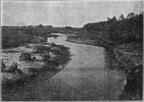
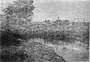
Prairie Creek -- looking west. At a point about 9 miles north
of Central City.
Photo by F. H. Shoemaker
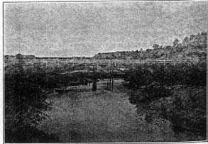
Prairie Creek Bridge -- 9 miles north of Central City.
Photo by F. H. Shoemaker
|
|
87 |
They then marched 3 leagues or 8 miles over a
plain until they reached the banks of a second creek, (Loup River)
which it was impossible to cross, and consequently they continued
to march 3 leagues more, along the banks of this creek to a plain,
where they halted and went into camp. Total distance marched on
this day, 7 leagues. Here two scouts reported, not to worry if
Capt. Naranjo did not return to camp that night.
Fri., Aug. 9. - The camp being ready to march, a
scout reported that the Pawnee camp was discovered the preceding
night 8 leagues distant on the other (north) side of the creek
they were following. Orders were given at once to cross the creek
(Loup River) which, although deep, was safely crossed. This
crossing of the Loup river was about four miles northwest of
Columbus, Platte County, Nebr.
They then marched down 3 leagues, or about 8
miles to the junction of the Loup River with the Platte, and
encamped about 11 a. m. at a distance of 5 leagues, or 13 miles
from the first discovered Pawnee camp. While in this camp the
Lieut. General named the creek (Loup River) Saint Lawrence.
From this junction camp, also, the Lt. General
sent Francois Sistaca16, the Pawnee savage of Capt. La
Serne, to parley with his tribe. He returned in the evening,
reporting that the Indians had moved 3 leagues, or 8 miles,
farther on, and were crossing the river to their village. When
they approached him, becoming frightened, he galloped 8 leagues
back to this junction camp.
Sat., Aug. 10, - The Spaniards marched the 8
leagues or 21 miles, along the north side of the Platte, until
they came in sight of the Indian village. After a parley the
Pawnee savage, of Capt. La Serne, was sent over the river to the
village with instructions and presents of tobacco.
The first discovered Indian camp, 5 leagues, or
13 miles from the junction was about south of the present
Schuyler. As the Indians moved on 3 leagues or 8 miles further to
cross the river to their village, this crossing was about south of
Rogers, and the village was located in the vicinity of the present
town of Linwood, an ancient Indian site.
According to the French version, it was in this
village that the massacre occurred.
Professor Thomas throws new light on the affair,
by giving us the Spanish accounts of the survivors of the
massacre. According to these accounts, the Spaniards waited
Saturday and Sunday, Aug. 10th and 11th for information, then
fearing treachery, they retreated 11 leagues, or 29 miles, instead
of 8 leagues, to the crossing of the St. Lawrence Creek, or the
Loup River, about four miles northwest of Columbus, and encamped
on the south side of the river, on the former site of their camp
of Friday, Aug. 9th.
It was here, on August 12th or 13th, according
to the Spanish versions, that the massacre
occurred.17
Let us hope that other documents may be found
that will tend to clear up all the difficulties, and doubtful
points.
Michael A. Shine.
|
88 |
|
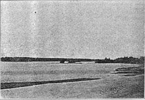
River Jesus Maria (Platte), "Full of Islands" -- near Pawnee
Trail Crossing.
Photo by A. E. Sheldon, Sept. 26, 1924
Warm Slough Bridge -- about 3 miles west of Central City.
Photo by F. H. Shoemaker
Vol VII, no 3, part 1 ![]()
![]()
![]()
![]()
![]() Vol
VII, no 3, part 3
Vol
VII, no 3, part 3
© 2001 for NEGenWeb Project by Ted & Carole Miller