NEGenWeb Project OLLibrary, Journals
NE History & Record of Pioneer
Days
Vol VII, no 3 (part 3)
NEBRASKA HISTORICAL SOCIETY
EXPEDITION
To the Platte-Loup Region in Search of Site of
Spanish
Massacre of 1720
A Discussion of the Topography, the Streams, the Spanish
Officer's Diary
By ADDISON E. SHELDON
"Spanish Expedition
Number" is the title of
Volume VI, Number 1, of the Nebraska History Magazine. It was
printed in 1924. The contents translated by me from recently
discovered Spanish and French documents, give an account of the
Spanish invasion of Nebraska in the summer of 1720 and the
complete defeat of the invading force by the Otoe and Pawnee
Indian tribes at some point in the Platte valley.
Baron De Villiers of Paris, France, the author
of this translated document, believes that the Spanish army was
exterminated near the junction of the Platte and Loup rivers. His
map, printed in the Nebraska History Magazine above referred to,
indicates this fact by a star and legend near the presennt (sic)
site of the city of Columbus, Platte county. The text of Baron
Villier's article, taken from the diary of a Spanish officer who
was killed in the battle, gives day by day account of the march of
the Spanish force, beginning August 6, 1720 and ending August 10,
1720. This diary describes the direction of the march, the number
of leagues marched, the streams encountered on the march and
location of the Indian villages.
On September 25, 1924, an historical expedition
left Lincoln on its way to the valley of the Loup and Platte. This
expedition consisted of Frank H. Shoemaker, photographer, E. E.
Blackman, curator Historical Society Museum, and Addison E.
Sheldon, Superintendent of the Nebraska Historical Society. Our
route was over S. Y. A. to Aurora, thence north to Central City.
We reached Central City early in the afternoon and spent the next
two days going over the territory between the Platte and the Loup
rivers.
The Spanish officer's diary says they crossed
the river Jesus Maria (identified as the Platte) where the river
was "full of islands" after following the Panane (Pawnee) trail
from the southwest. Pawnee trails
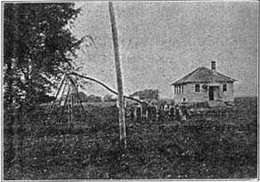
School House -- Dist. No. 38 -- about 6 Miles southwest of
Central City, near
Pawnee Trail Crossing of Platte.
Photo
by F. H. Shoemaker
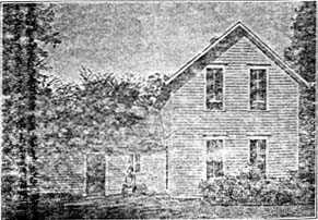
Home of John McMann (Oldest Settler
in Merrick County). Pawnee Trail
crosses his farm.
Photo
by F. H. Shoemaker
leading southwest from the ancient Pawnee villages on the Loup
crossed the Platte at several points. On Lieutenant Fremont's map,
made in 1842, the principal Pawnee Trail is marked as reaching the
Platte just east of the lower end of Grand Island, between the
present towns of Chapman and Central City. We adopted the theory
that near here was the crossing of the river Jesus Maria by the
Spanish army.
The Spanish officer's account says that at a
league distance from the river Jesus Maria they found a large
creek flowing from west to east whose water was very warm. Warm
Slough Creek is such a stream, except that it would not ordinarily
be called a large creek. It was named by the early white settlers
of Merrick county because its waters were warmer than other
streams. It flows from west to east for about fifteen miles,
nearly parallel with the Platte and from two to four miles north
of that stream.
After crossing Warm Slough the Spanish army
marched over a plain following the Indian trail. They marched
about three leagues (a Spanish league is 2.63 miles) and reaching
another creek difficult to cross, they followed this creek about
three leagues more on the south side. There they camped over
night. Prairie Creek, in Merrick county, in a general way, meets
the description of this creek as described by the Spanish
officer's diary. It flows from west to east entirely across
Merrick county, a distance of about thirty miles. A smooth,
elevated plain, visible from afar, marks the divide between
Prairie Creek and the Platte for part of this distance.
The next morning, August 9, 1720, the Spanish
officer's diary says their scouts reported that they had
discovered the Indian village, eight leagues distant on the other
side of the creek they were following and that the savages were
singing and dancing there in great numbers. This village is
further described as "being in a bottom". Eight leagues (about 22
miles) from the camp of the Spanish army, in the general direction
of the trail would bring them to the Loup river at some point
between Fullerton and Columbus, depending upon the angle of the
trail.
At this point it is not perfectly clear from the
Spanish officer's account where the army reached the Loup, which
the general named the St. Lawrence, or in Spanish San Lorenzo. It
is also not perfectly clear where the Spanish army crossed Prairie
creek. But the general conformity of the streams, the topography
of the country, the direction of the trails, and the distances fit
the region of Merrick and southern Nance counties, in most
particulars.
In addition to the general correspondence
between the region as described by the Spanish officer's diary and
as it appeared to the Nebraska Historical Expedition on this trip
it is a well known fact that the Pawnee Indians for a long time
prior to the coming of the whites occupied the region of the Loup
river. The ruins of their ancient villages are still found and the
evidences indicate occupation at least two or three hundred years
ago, perhaps much longer.
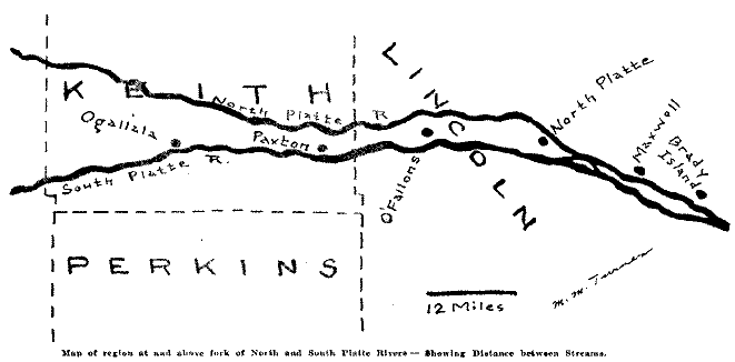
The region between the north and south forks of
the Loup river in Lincoln county does not correspond with the
Spanish officer's diary with respect to the distances between the
river Jesus Maria and the river or creek San Lorenzo. There are no
streams there corresponding to the Warm Slough or Prairie creek as
described in the Spanish officer's diary. The river "full of
islands" might describe the South Platte at this point, but the
distance between the two Plattes is too narrow to fit the account
of the Spanish army's march.
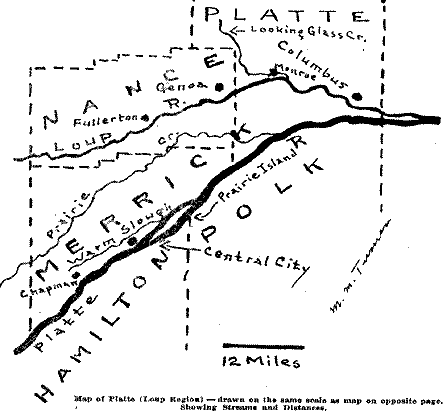
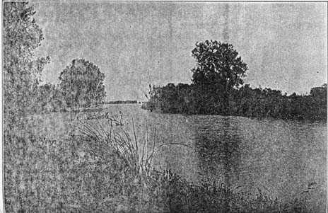
Junction of Prairie Creek with the Platte -- about 10 miles west of
Columbus -- looking east,
SPANISH CHAIN ARMOR ON THE
LOUP
Curator E. E. Blackman of the Historical
Society Museum, began exploration of ancient Indian village sites
on the Loup river twenty-five years ago. In 1924 and 1925 he spent
some weeks in this field. He was a member of the survey party from
the Historical Society which was over this ground in September,
1924. Asked to give his contribution to the present discussion, he
writes as follows:
"The Loup river from Columbus to a point twenty
miles west of Fullerton is thickly studded with ruins of Indian
village sites. The Pawnees lived in this area. Many of these ruins
date prior to 1720.
"Near the mouth of the Looking Glass Creek,
which flows into the Loup near the present town of Monroe is an
extensive ruin, on the S. E. 1/4 of See. 3, T. 17, N. R. 3 W. The
ruin is near the creek, on the north bank and the Loup river is
over a mile south of the creek. Miss Matson informed me that many
small brass plates, like those used in quilted armor in 1720, and
like the three found west of Genoa, were dug up near one of the
house sites about ten years ago.
"I met a gentleman near Monroe in 1924 who found
a number of Spanish coins where they had been unearthed from a
post hole twenty years ago. Charley Green of Marquette, Nebraska,
found part of a stirrup and the top of a helmet said to be Spanish
in design, near the old Chaui village across the Platte from
Clarkson, Nebraska, about 35 years ago. A brass chain,
distinctively Spanish, was found near Genoa two years ago.
"The finding of these numerous trinkets, which
may well be relics of this Spanish Caravan together with the
description given in the "Officer's diary" leads me to believe
that the massacre occured (sic) at this village on the Looking
Glass.
"If the caravan was at the mouth of Prairie
Creek (the St. Lawrence), where it joins the Platte (Jesus Maria)
on the morning of August 10, 1720. the distance travelled (sic)
and the physical condition described in the text fits the locality
quite well.
"Further exploration may substantiate this
supposition."
ADDITIONAL REFERENCES ON VILLASUR
EXPEDITION
Batel-Dumont, Memories Historiques sur la Louisiane, vol. II,
pp. 283-288.
Bossu, Noveau Voyage aux Indies Ocidentales, vol. I, pp.
150-155.
Bienville, Letters to the council of the Regency, from Fort Louis,
of Louisiana, July 20, 1720, and April 25th, 1722.
Le Page du Pratz, 1759, Historie de la Louisiane, avec deux
Voyages dans le nord du Nouveau Mexique, vol. 2, pp. Z46-251.
Bernard de ]a Harpe, journal Historique de la Establissement
des Francais a la Louisiane, pp. 249-250.
P. de Charlevoix, Journal of a Voyage to America, vol. 2, p.
64.
James Reynolds, The Pioneer History of Illinois, p. 34.
Joseph Wallace, History of Illinois, p. 268.
Maj. Amos Stoddard's Historical Sketches of Louisiana, chapter 8,
p. 128.
R. H. Bancroft, History of Arizona and New Mexico, pp.
236-237.
L. Bradford Prince. Historical Sketches of New Mexico, p. 225.
Some of the above writers, notably the first
three, relate the story of the Spanish expedition with a good deal
of exaggeration and indicate that the Spanish were overcome by the
Osage and Missouri Indians in the region of East Kansas and
Western Missouri. These French narratives are made from frontier
rumors. They lack the authenticity of the Sepanish (sic) records
made up from those who directed the expedition from Santa Fe.
SPANISH RELICS NEAR GENOA
(The following correspondence relating to
military and possibly Spanish evidences in the Loup Valley region
indicates a wide interest. Beyond doubt there are many places in
the Loup Valley where research will be rewarded by further
evidences of military expeditions.)
Granite Falls, Minn.
May 18, 1924.
Supt. Sheldon:
The writer had some correspondence not long
since with Mr. Warren Upham of St. Paul, Minn., in regard to
ancient relics of seemingly Spanish origin found near Genoa,
Nebraska. My last letter from him tells of receiving a number of
your Society's publication containing account of a Spanish
expedition into Nebraska where it was nearly exterminated by some
of the Indian tribes.
A party who as a boy had attended the Genoa
school told me of finding old guns and armor and pouches of
bullets there which the boys used to trade to a druggist in town
for tobacco.
A year ago I was married to a woman, who once
attended this school and wishing to verify the above account, before
laying the matter before your Society, I inquired of her. She
recognized the proposition away and said, "Yes, when us girls used
to swim in the river we a found bullets in the river bed." She had
also heard of several old shields being dug up, also knives and
swords.
In regard to the village site, Mr. Blackman
reports that the Pawnees knew nothing of that. My wife says that
her school companions from the southern tribes knew of this
village site and stated that it was very ancient and had been
occupied successively by different tribes or bands. It is very
difficult for a stranger to learn anything from the Indians by
inquiry, but if anyone belongs to the tribe and knows the language
he will hear a thousand things he never expected to hear.
I would be very much interested in receiving a
copy of your Society's publication containing the account of that
old Spanish expedition.
Hoping to hear from you, I am
Frederic W. Pearsall.
Granite Falls Minn.
Dec. 15, 1924.
Supt. Sheldon:
I received your society's magazine last spring
containing the account of the Spanish expedition into Nebraska in
1720.
I have studied this with much interest. I
believe there must be a tradition among the Oto and Pawnee Indians
of that battle, but it is something hard for strangers to find. I
am acquainted with only one Oto. When my wife was at Genoa school
she made more or less acquaintance with those southern tribes.
Their name for Beaver Creek is Black Pipe creek, or
Canduhupa-sapa-wakpadan, and our tribe always called Loup River
Wamnuhra ota wakpa or Many Periwinkle river. This probably was
translation of some southern tribe's name.
Did your society make any investigation around
Genoa last summer?
Please let me hear from you.
Vol VII, no 3, part 2 


Return
to NE History & Record
of Pioneer Days
© 2001 for NEGenWeb Project by Ted &
Carole Miller
© NeGenWeb