|
104 |
|
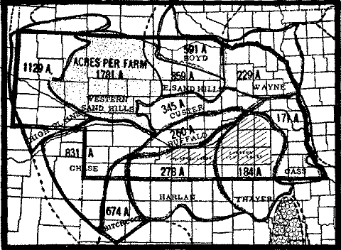
FIG. 1.--Areas in Nebraska which have a fairly uniform type of farming (see Table 2).
NEGenWeb
Resource Center
On-Line Library
|
100 |
|
Of course, the rate of growth and development of corn plants have been determined with certain definite amounts of water in the laboratory. But to try and answer the oft repeated question as to just what rainfall amounts are actually beneficial to the growing corn, a method has been evolved which indicates that in Franklin County, Ohio, for a 20-year period rainfalls of 0.50 or more are the most effective in determining yield. The general rule has been stated that for equal quantities of rain its value in agriculture increases as the number of rainy days diminishes, and on the other hand diminishes as the number of rainy days increases. This can be true, however, only up to a certain point.
SIZE OF FARM IN THE GREAT PLAINS AS DETERMINED
BY RAINFALL AND OTHER FACTORS
R. A. SPAFFORD, LINCOLN
DEFINITION OF THE TERM FARM
A farm, generally speaking, is the area of land from which a family derives a living through such operations as cultivating crops, cutting wild hay, pasturing native grasses, and feeding live stock. Broadly construed this definition makes it possible for a single farm to include owned land, leased land, and free range. If the area of free range were to be excluded the use of the term farm in this study would be similar to its use in the Thirteenth Census.Two extracts from the general agricultural schedule (1910) will serve to illustrate the census use of the word farm.
FARM.--A "farm," for census purposes--that is, for which a general farm schedule should be obtained--is all the land which is directly farmed by a single person, managing and conducting agricultural operations, either by his own labor alone or with the assistance of members of his household or of hired employees. The term "agricultural operations" is here used as a general term referring to the work of growing crops, producing other agricultural products, and raising animals, fowls, and bees. A farm as thus defined may consist of a single tract of land or a number of separate and distinct tracts situated in the same or in different enumeration districts, and may be held under different tenures, as where one tract is owned by the farmer and another tract leased by him.
For example, if A B operates or cultivates under his personal management one tract of 60 acres in one place and another tract of 30 acres in another place, these two separate tracts constitute one farm of 90 acres. But if A B owns 90 acres of land in one tract but cultivates under his personal management only 60 acres of such tract and leases the other 30 acres to another person, C D, the farm of A B consists of but 60 acres--that is, the number of acres actually farmed or operated by him, the remaining 30 acres constituting the farm, or part of the farm, of C D. Or, again if A B owns 90 acres of land which he ordinarily considers as "his farm" but leases 30 acres from C D,
|
|
101 |
then the farm of A B consists of 120 acres--that is, the total number of acres actually farmed by him.RANCHES USING PUBLIC LANDS.--The farm of a ranchman using the public domain includes only the land which he owns or leases. If he leases public land or any other land, such land is a part of his farm. But his farm does not include any public land for which he pays no rental or upon which live stock are grazed at a fixed charge per head. Across the head of schedules for farms and ranches using public lands for grazing live stock write RANGE in large letters. In cases where cattle are grazed wholly upon the public domain and the owner of the animals does not own or lease any land, fill out a schedule for the owner of the same as for any ordinary farm operator, omitting answers, however, to Inquire 10 to 15 and writing in answer to Inquiry 6 the words "No land owned or leased."
When we exclude from a farm public land for which a farmer "pays no rental or upon which live stock are grazed at a fixed charge per head" we decrease, to that extent, the area of land from which he derives a living and his farm cannot be directly compared with one having no free range.
For western Nebraska the Thirteenth Census reports that less than two-thirds of the total area of land was occupied by farms. Field studies at many points in that part of the state lead one to believe that the people living here in 1909 would have been seriously handicapped in making a living had even the poorest one-third of the total land area been wholly excluded from agricultural use. A farm management survey made in Kimball county in 1915 indicated that the size of farm in the county was nearer two sections of land than one section as reported in the census. In all probability the number of farms in Kimball county had increased since 1909, and so it can hradly (sic) be true that a farm at that time consisted of only one section of land. It was also observed during this survey that the area of pasture land not grazed over at some time during the year was almost negligible.Table I compares the average size of farms taken at random in Nebraska Farm management surveys with census figures. In most cases the average size of farm secured through surveys (1914-1916) is more in harmony with the result obtained by dividing the total land area of the county by the number of farms it contained in 1909, than with the size of farm given in the census. If the survey figures can be relied upon it is safe to state that practically the entire area of land is made to contribute in one way or another to the living of farmers located upon it. It is a commonly known fact that nearly every western area had, at some time previous to the last census, seen ranchers strongly opposed to increasing the number of farms. Even in those times they must have felt that, to make a living under such economic conditions as they were experiencing, it was necessary to use practically all of the land.
|
102 |
|
The first calculations of the size of farm per county in this state were based upon the assumption that only a very small part of a county was not being used by the people farming there. An attempt was made to eliminate from the total acreage of each county (1) the area occupied by the very small farms reported in the census and (2) the area occupied by town lots and railroads. It was soon found (1) that the very small farms (under 3 acres, 3 to 9 acres, etc.), could not be consistently separated from the larger farms and (2) that the area of land occupied by towns and railroads combined did not as a rule amount to one per cent of the area of the county. Further studies brought out the fact that the relation between the number of very small farms and the area of laud occupied by towns and railroads was such
|
|
|
||||
|
|
|
|
|
|
|
|
Western counties: |
|
|
|
||
|
Kimball |
|
|
|
|
|
|
Box Butte |
|
|
|
|
|
|
Dawes |
|
|
|
|
|
|
Thomas |
|
|
|
|
|
|
|
|||||
|
Phelps |
|
|
|
|
|
|
Seward |
|
|
|
|
|
|
Madison |
|
|
|
|
|
|
Thurston |
|
|
|
|
|
that one always tended to offset the effect of the other when the total area of the county was divided by the total number of farms. Figures bearing upon the size of farm in the vicinity of Omaha will illustrate this tendency of very small farms to offset even a large area of land in town lots and railroads. According to the order followed in the first method of study, it was estimated that Douglas county, in which Omaha is located, had 29,560 acres of land occupied by towns, railroads, and very small farms. The remainiing (sic) area of Douglas county was then divided by the number of larger farms. This gave 168 acres per farm. Following the order of the second method the total area of the county was simply divided by the total number of farms. This gave 123 acres per farm. As a cheek on these figures a field study (1917) was made in Papillion precinct in Sarpy county some
|
|
103 |
seven miles southwest of the South Omaha market. The area covered was 18,880 acres. The average size of farm here proved to be 126 acres. Judging from this study and also from field observations in practically all precincts in Douglas county, the second method of calculating the size of farm gives a more accurate idea of open farming country than the first. Another very important point in favor of the second method is its freedom from any arbitrary rulings concerning very small farms.When the total area of the county is used, it gives a stable basis from which to measure any change in time average size of farm brought about through either an increase or decrease in the number of farms. Table 2 illustrates the importance of this fact. In the first column of the table are found the names of the type areas in Nebraska and also the total area of the counties used in determining the average size of farm. The second column contains the number of all farms in 1900
|
|
|
|
|
|
||
|
|
|
|
|
|||
|
|
|
|
|
|
|
|
|
Cass, 2,311,240 acres used . |
|
|
|
|
|
|
|
Thayer, 5,959,680 |
|
|
|
|
|
|
|
Wayne, 4,747,087 |
|
|
|
|
|
|
|
Buffalo, 2,542,720 |
|
|
|
|
|
|
|
HarIan, 5,521,280 |
|
|
|
|
|
|
|
Custer, 2,829,440 |
|
|
|
|
|
|
|
Boyd, 2,369,920 |
|
|
|
|
|
|
|
Hitchcock, 3,091,040 |
|
|
|
|
|
|
|
Chase, 4,231,040 |
|
|
|
|
|
|
|
E. Sand Hills, 2,994,560 |
|
|
|
|
|
|
|
High Plains, 4,753,280 |
|
|
|
|
|
|
|
W. Sand Hills, 5,818,240 |
|
|
|
|
|
|
that were located within the area of land indicated in the first column of the table. The third shows the number of all farms within this same area of land in 1910. Columns 4 and 5 of the table give the calculated average size of farm for 1900 and 1910 respectively while Columns 6 and 7 give the average size of farm as recorded in the census. It will be observed that there the number of farms in 1910 shows an increase over 1900, the average size of farm recorded in the
|
104 |
|
FIG. 1.--Areas in Nebraska which have a fairly uniform type of farming (see Table 2).
census decreases in eastern areas and increases in western areas. For example, in 1900 some five million acreas (sic) of land in the western Sand Hills held 1,334 farms. Ten years later the number of farms on this area of land had increased to 3,266. The total area of land divided by the number of farms gives 4,359 acres per farm in 1900 and 1,781 acres in 1910. From the standpoint of the average area of land required to make a family living in these years the figures are not far out of line with the experience of thrifty ranchers and farmers living there. Regardless of the fact that the number of farms in the western Sand Hills more than doubled between 1900 and 1910, the census records a 30 per cent increase in the size of farm. This increase in size would not appear if all land grazed had been included in farms.It is seldom that large areas of grass land in the Great Plains are so completely withheld from farm use as to reduce agricultural practices to zero. Where land is partly withheld by farmers and ranchers they simply practice more extensive methods of farming than other factors in the region would actually require. What is here said of grass lands will not apply to the timber lands found in northern Minnesota and Wisconsin. In this timbered area part of the land is used by lumber companies and cannot be classed as land in farms. The fact that much of this heavy timber must be cleared before the land
|
|
105 |
can have any farm use makes it relatively easy to hold large tracts of land from agricultural use. From these facts it can readily be infered (sic) that in a timber region the area of a county divided by the number of farms contained cannot give a true index to the average size of farm. Though size-of-farm lines, so determined, have been drawn across northern Minnesota and Wisconsin they are only of value when compared with the acres per person. A study of Figures 11, 12, 13 and 14 in comparison with Figures 15, 16, 17 and 18 will bring out the fact that the land in northern Minnesota and Wisconsin furnishes a living for more people than is indicated by the size-of-farm lines. It will be observed that ordinarily in a grass-overed region the 1280-acre lines are found very close to the lines indicating 200 acres per person (total population). The 1280-acre lines drawn across the timber region would probably cross about as far north as the lines indicating 200 acres per person if it were possible to reduce lumbering to a farm basis.A summary of the above discussion will bring out more clearly the chief considerations that led to basing size-of-farm studies in the Great Plains on simply the area of a county divided by the number of farms contained. (1) When a farm is defined as the area of land from which a family derives a living through such operations as cultivating crops, cutting wild hay, pasturing native grasses, and feeding live stock, nearly all of the land in the Great Plains can be looked upon as farm land. (2) The area occupied by town lots and railroads tends to be offset by the number of very small farms. (3) The total area of the county gives a stable basis from which to measure any changes in the average size of farm due to a change in the number of farms.
From county data contained in the census the size of farm has been determined for each county (counties in Oklahoma excepted)* in the Great Plains region and certain bordering areas to the east. The study includes census reports as far back as 1880. Maps drawn after the plan of those commonly used by the Weather Bureau are here used to summarize the size-of-farm data. This method of mapping makes it a simple matter to compare the trend of any given size-of-farm data. This method of mapping makes it a simple matter to compare the trend of any given size-of-farm line with the trend of precipitation lines.
In 1880 the 160-acre farm was common as far west as northwestern Missouri, central Iowa, and southwestern Wisconsin. A study of_______
*Since Oklahoma did not develop in harmony with the other states in this region it is here omitted.
|
106 |
|
Figure 6 will show that the 160-acre lines remained almost stationary in Kansas, Nebraska, and Iowa for a period of thirty years. The great expansion during the period between 1880 and 1910 took place to the west, north, and south of this strip of country. Barring soil effects the western edge of quarter-section farming follows very closely a normal annual precipitation of from 31 to 32 inches (See Figure 5). In eastern Kansas the 160-acre lines are usually found in counties having from 35 to 40 inches of rainfall. It is here that the "flint hill section" holds the 160-acre lines to the east. In Texas the 160-acre farm advanced much farther south than west. The westward advance against a decreasing rainfall was scarcely greater than that taking place in the states to the north.
The principal factors affecting the size of farm in the drier parts of the Great Plains can best be introduced through a study of the 1280-acre lines. (See Figure 10 and also Figures 11, 12, 13 and 14). Between 1880 and 1910 two-section fanning in South Dakota moved from a country having 24 inches of rainfall to one having 46 inches. In central Texas during the same period this size of farm occupied the strip of country lying between the 21 and 26 inch rainfall lines. While 1280-acre farming in South Dakota advanced through approximately an 8-inch decrease in rainfall, it advanced through only about 5 inches in central Texas. The slower advance against rainfall in the south can be attributed largely to two factors, namely, greater evaporation and somewhat slower development of country. Of the factors mentioned, evaporation appears to have the greater influence.In North Dakota and Texas the 1280-acre lines make a fairly regular advance during each ten-year interval following 1880. In contrast with these regular movements the lines at many points in South Dakota, Nebraska, and Kansas show a number of reactions. This is particularly true of the lines making the western edge of two-section farming in 1890 and 1900. One of the outstanding features of the 1280-acre line in 1890 is its marked westward bend into northeastern Colorado. Within this bend homesteading reached one of its highest points. In the late 80's and early 90's people here occupied a country developed more out of harmony with rainfall and heat than could be found at any point either to the north or to the south. The line drawn for the year 1900 gives at least a partial view of the reaction that followed.* It was most severe in southwestern Nebraska and northwestern Kansas. To the north and south of these areas the reactionary movement gradually disappears.
_________
*It most be borne in mind that some actions and reactions were so sharp that measurements made at ten-year intervals could not fully record them.
|
|
107 |
SIZE OF FARM IN RELATION TO RAINFALL. AND HEAT
The size of farm in 1880 and 1910 was probably more uniformly adjusted to rainfall and heat than it was in either 1890 or 1900 (See Figures 11, 12, 13 and 14). Nevertheless, each map in the series just referred to shows a tendency for its lines to converge to the south more rapidly than rainfall (See Figure 5). This convergence is more readily seen when the lines in the eastern quarter of Texas are covered. Figure 2 is a diagram on which the 1910 size-of-farm lines are plotted according to inches of rainfall used as degrees of longitude and month-degrees used as degrees of latitude. The 320-acre line and the lines to the east of it follow approximately the same quantity of rainfall regardless of an increase or decrease in the quantity of heat. To the vest of the 320-acre line the section and two-section size of farm veer rapidly into higher rainfall to the east as the quantity of heat increases to the South.
From the preceding discussion one might be led to infer that the position of size-of-farm lines in the Great Plains is seldom affected by soil. The series of maps last referred to (Figures 11, 12, 13 and 14) can also be used to illustrate certain soil effects. The ''Flint Hill' section in Kansas was mentioned during a discussion of 160-acre lines. In 1880 this section stood out as an insland (sic) of half-section farming in eastern Kansas. In 1890, 1900 and 1910 the size of farm is seen to be somewhat reduced but it still stands out as an area occupied by rela-
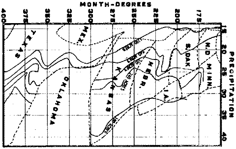
FIG. 2.--The size-of-farm lines for 1910
plotted on a diagram which uses rainfall as degrees,
of longitude and month-degrees * as degrees of latitude.
* Month-degrees at the University Farm, Lincoln, Nebraska. Normal mean temperature--Jan. 24.9; Febr. 25.3; March 41.6; Apr. 52.7; May 62.3; June 71.1; July 76.0; August 75.0; Sept. 67.4; Oct. 55.0 ; Nov. 40.6; Dec. 28.1. (41.6+52.7+62.3+71.1+76.0+75.0+67.4+55.0+40.6)-(9x32)=253.7 month-degrees above freezing.
 |
 |
 |
 |