FIG. 3.--A cross- section measurement of
size of farm following approximately
the line of 240 month-degrees from Iowa into Colorado.
|
|
109 |
NEGenWeb
Resource Center
On-Line Library
|
108 |
|
tively large farms. The Sand Hill region in north-central Nebraska has even a more marked effect upon the size of farm. On the map of 1880 (Fig. 11) the two-section and one-section lines in northeastern Nebraska bend sharply to the east in order to avoid the Sand Hills and bordering areas of more or less sandy land. In 1890 these lines enter the eastern Sand Hills. In 1900 they recede to the eastern edge where they almost meet the half-section line which has moved a little to the west and is just beginning to bend eastward in order to avoid sandy land. By 1910 the two-section line has passed beyond the Sand Hills leaving behind it an island of very large farms to occupy the western part. While section farming has again entered the eastern Sand Hills, half-section farming in 1910 still skirts the edge.
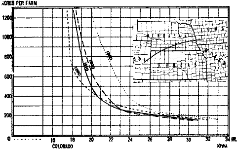
A cross-sectional measurement of size of farm in the Great Plains region will bring out certain facts concerning rainfall and economic conditions more clearly than can be pointed out from maps. Figure 3 is a cross-sectional measurement following approximately the line of 240 month-degrees from Iowa across southeastern Nebraska and northwestern Kansas into Colorado. The purpose of following a given quantity of heat is to eliminate in as far as possible the effect of heat upon the size of farm. The choice of this particular quantity of heat was influenced by the fact that it crosses the Great Plains at a point where soil variations are slight. It is even possible that the western
FIG. 3.--A cross- section measurement of
size of farm following approximately
the line of 240 month-degrees from Iowa into Colorado.
|
|
109 |
soils being a little more open and more level than the eastern soils give a slight advantage to the western farms. With effective variation in both heat and soil largely eliminated, the study along this line can be more positively centered upon the size of farm in relation to rainfall and economic conditions. In this graph rainfall tends to give similarity to the shape of the curves while economic conditions are largely responsible for their position relative to one another. Each of these curves shows that as soon as rainfall is decreased below a certain point the size of farm increases rapidly. This point in rainfall is sometimes designated as critical rainfall. Along the line of the graph critical rainfall varies with economic conditions. Thus in 1880, 1890, 1900 and 1910 critical rainfall stood at approximately 25.0, 19.5, 22 and 21 inches respectively. It is a rather striking fact that between 1880 and 1910 the critical point in rainfall along this line had been lowered only about 4 inches. When cross sectional studies of this kind are made across the northern part of the Great Plains, the curves reach into lower rainfall and are less sharp. On the other hand, cross-sectional studies to the south of the 240 month-degrees line give very sharp curves that do not reach into extremely low rainfall.
The connecting link between size of farm and moisture conditions in the Great Plains is plant growth. It stands to reason that where rainfall is normally low and as a result crop yields are low and pasture growth is sparse, a farm must of necessity occupy enough land to bring the total annual growth of usable plants to a level that will
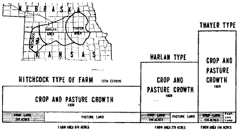
FIG. 4.--The relation of the size of farm to the total annual growth of crops and pasture.
|
110 |
|
insure farm family a living. Figure 4 gives a view of the size of farm in relation to the total annual growth of crops and pasture. As shown by the key map accompanying the figure the heat and soil conditions in the areas chosen are much the same as those described in the preceding cross-sectional study. In the accompanying diagram the blocks placed adjoining one another illustrate how a farm in the Great Plains adjusts its area to overcome the effects of low crop yields and short pasture growth. The base-length of a block represents the total farm area. (Note here Table 2, columns 1 and 5). The division of the farm area between crop and pasture land is brought out by shading. The height of one block relative to another (the height above the shading is in harmony with the crop index of one farm type relative to another. The crop index of each of these farm types was calculated from the census and applies only to the crop year 1909. When the crop and pasture growth in the Thayer area was assumed to he 100 per cent the Harlan and Hitchcock types measured 60.2 and 32.0 per cent respectively. Though these measurements are based on only the crop year 1909 they serve very well as an index to normal conditions. According to the results obtained, 100 acres of the Harlan type of farm were equivalent, in 1909, to 60.2 acres of the Thayer type in this year, 100 acres of the former were about equivalent to 32 acres of the latter.This principle of adjusting the size of farm to the quantity and value of plant growth is as old as dry land farming. It is practiced in all of the dry border regions of the world. Field studies in Nebraska lead one to conclude that whenever this principle is not complied with the would-be dry farmer is barred from success.
 |
 |
 |
 |