   |
The Historical Development of
|
| Ohio became a state in 1803, and at that time the area that eventually became Guernsey County was divided up between Washington and Belmont Counties. The state legislature subsequently created many additional counties with specific acts of legislation. Note that a county didn't begin functioning until sometime later when it was organized, and before that time records would be found with those of the parent county. In 1804 Muskingum County was created and organized, from the northern portion of Washington County. In early 1810 Guernsey County was created out of Muskingum and Belmont Counties, and it was organized 1810 March 1. The southeast portion of Guernsey County was later incorporated into the county of Monroe (created 1813 January 29, organized 1815). Much of the southern portion of Guernsey County was then removed to help form the county of Morgan (created 1817 December 29, organized 1819 April). On 1851 March 11, another southern strip of land was given to the new county of Noble.
The U.S. Military District was established in 1796, lying to the west of the first Congressional survey and to the north of the second Congressional survey. It was used as payment for service in the Revolutionary War, though many veterans sold their bounties to others, and beginning in 1803 unclaimed land was sold on the open market. Unlike the Congressional surveys, the Military District's ranges and townships are five miles wide and five miles square, respectively. In addition, although they are numbered in the same fashion as for the Congressional lands (south to north, east to west), the numbering is not continuous with them, beginning anew in the District's southeast corner. So, for example, Cambridge is located in Range 3, Township 2. The legislative act establishing Guernsey County in 1810 describes its boundary as: "Beginning at the center of the fourth range, on the line between the fourth and fifth tiers of townships in said range (of United States military lands); thence east with said line to the western boundary of the seventh range; thence south to the southwest corner of the county of Tuscarawas; thence east through the center of the eleventh township of the seventh range of Congress lands to the line between the sixth and the seventh ranges; thence south with the said line to the northern boundary of the County of Washington; thence west with the said boundary line, through the center of the fifth township of the seventh range; thence north to the center of the sixth township of the eighth range; thence west with the northern boundary of Washington County, to the line between the tenth and eleventh ranges; thence north with said line to the southern boundary of the United States military lands; thence west with said line to the southwest corner of the first township in the fourth range; thence north to the northwest corner of the third township of the fourth range; thence east to the center of the fourth range; thence north to the place of beginning." As a result, the eastern end of Guernsey County lies in the 7th range of the Congressional lands. The southern end of the county lies in the 8th, 9th, and 10th ranges of the Congressional lands. The rest of the county lies in the 1st through 4th ranges of the U.S. Military District. Because these numbers from the different surveys are distinct within Guernsey County, one doesn't need to reference the survey a township is from, only its range. These numbered townships are further divided, the manner depending on the particular survey. Most numbered township in the Congressional surveys are about six miles square, and are divided into thirty-six sections, each of which are roughly one-mile square (640 acres). They are numbered with two different schemes, depending on the date of the survey. The townships in the initial Congressional survey, which includes the 7th range in eastern Guernsey, are numbered similar to the townships themselves, from south to north and then east to west: 36 30 24 18 12 06 In the original Ordinance of 1785, Congress set aside the 16th section for educational purposes (the first such federal support), and reserved to itself sections 8, 11, 26, and 29. Beginning in 1796, the reserved sections were changed to 15, 16, 21, and 22.
06 05 04 03 02 01 Each section was broken into quarters of about 160 acres each, which are referred to by their compass position, NE, NW, SW, SE, or sometimes halves of 320 acres each, described by N, S, E, or W. Section quarters were again broken into quarters of 40 acres each, or sometimes halves of 80 acres each. The former were described by terms such as "SW of NE", the latter by "E of SW". See the diagram at the right showing four sections and the different ways they might be broken up. In the Military District, the numbered townships are approximately five miles square, and are broken up into four quarters of roughly 4000 acres that are numbered as follows: 2 1 The earlier quarters were broken up into 100-acre lots, while the later quarters were broken up into full and half sections to match the scheme in the Congressional surveys.
33 27 21 15 09 03 (T10) Current and former townships are:
Londonderry, Oxford, and Millwood Townships were once part of Belmont County, while the rest were part of Washington Township in Muskingum County. Beaver, Seneca, Buffalo, and Ohio Townships (now Wayne Twp.), along with portions of Richland Township were taken from Guernsey County to help form Noble County. References: “Evolution of Ohio County Boundaries”, Randolph Chandler Downes, M.A., in Ohio Archaeological and Historical Quarterly, v. 36, p. 340 (1927). Ohio Lands - A Short History, Dr. George W. Knepper, published by the Ohio Auditor of State. |
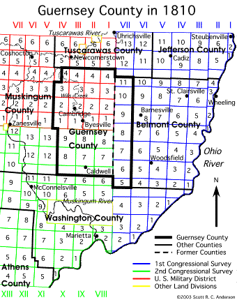 The boundaries of Guernsey County and its townships are based on three different land surveys, two Congressional (Ohio River) surveys and the U.S. Military District. The first Congressional survey was the Seven Ranges, begun in 1786 (and finished in 1802), followed by the second survey in 1795. These two surveys divide Ohio into strips of land roughly six miles wide called ranges, which begin at the Ohio River in the south and run due north. They are numbered continously beginning with the eastern boundary of Ohio and increasing to the west, so that the first survey's 7th range lies adjacent to the second survey's 8th range (these are the roman numerals in the picture at the right). Each range is then broken up into townships that are approximately six miles square, and which are numbered from south to north. These two numbers, range and township, are therefore all that's necessary to locate one's position within these surveys. Barnesville, therefore, is located in Range 6, Township 8.
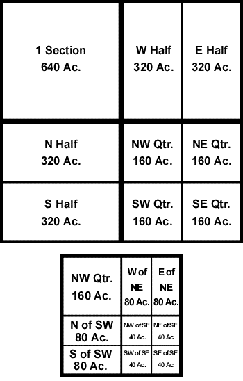 The sections in ranges 8-10, on the other hand, which run through southern Guernsey County, are numbered from north to south and alternating east to west and west to east, as follows:
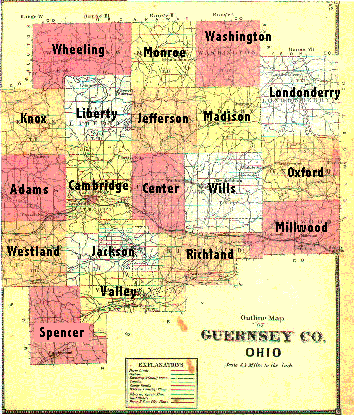 Named or political townships are made from pieces of the original numbered townships by order of the Guernsey County Commission. Few of the named townships correspond exactly to numbered townships, but instead consist of one or more portions from two or more townships. For example, Oxford Township in Range 7 contains sections from both Township 9 and Township 10:
|
|